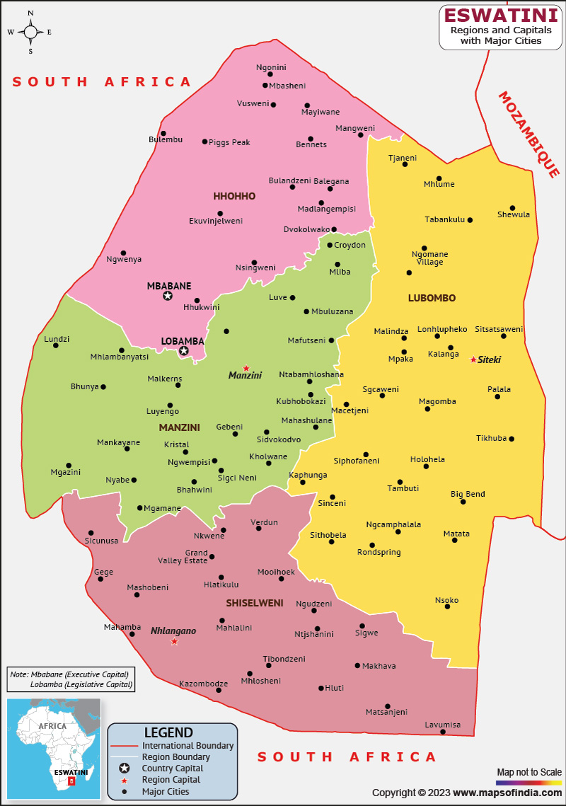
Southern African nation Eswatini, previously Swaziland, is a landlocked nation. Mbabane is the country's largest city and capital, however Lobamba serves as the administrative center. Eswatini has a population of about 1,191,982 and a total area of about 17,364 square kilometers (6,704 square miles). The Mlilwane Wildlife Sanctuary and the Malolotja Natural Reserve are only two examples of the nation's amazing wildlife, breathtaking landscapes, and rich cultural heritage. Eswatini is a constitutional monarchy, with King Mswati III as the head of state and government.
History:
Once known as Swaziland, Eswatini is a landlocked nation in Southern Africa. Eswatini's history began in the 18th century, when the Bantu-speaking Swazi people came there. The monarchy that oversaw the nation was put into place by King Mswati II in the middle of the 19th century. The British colonized Eswatini in the late 19th and early 20th centuries, and they ruled it until it gained its independence in 1968. Eswatini maintained a monarchy after gaining independence, with Mswati III, the reigning monarch at the time, coming to power in 1986.
Culture:
Eswatini's culture is extensive and varied, influenced by the nation's history, customs, and natural environment. The majority of the population, the Swazi, are recognised for their hospitality and kindness and have a strong sense of community. Traditional Swazi culture is characterized by song, dancing, and storytelling. During the year, numerous ceremonies and festivals are held to commemorate significant occasions and anniversaries. The nation is renowned for its lively arts and crafts, like weaving, ceramics, and beadwork, which are frequently offered for sale in neighborhood markets and boutiques. A variety of animals, including lions, elephants, and rhinos, can be found in Eswatini's national parks and game reserves.
Language:
The official language of Eswatini is Swazi, which is a Bantu language spoken by the Swazi people. English is also widely spoken, particularly in urban areas and among the educated population. There are several other languages spoken in Eswatini, including Zulu, Tsonga, and Afrikaans.
Geography:
The terrain of the nation is varied, with a central plateau rising to a height of 1,862 meters above sea level. The Lebombo Mountains, which create a natural border between Eswatini and Mozambique to the east, are one of numerous mountain ranges that surround the plateau. The Great Usuthu River, the main river in Eswatini and a portion of the border with South Africa, is one of many rivers that flow across the nation. Eswatini has a pleasant, temperate climate with cold winters and balmy summers. The nation contains a variety of vegetation types, including marshes, grasslands, and savannas, which provide homes for numerous species of wildlife. Eswatini's varied geography makes it a popular tourist destination.
| Official Name | Kingdom of Eswatini |
| Capital | Mbabane (executive) |
| Lobamba (legislative) | |
| Population | 1191982 |
| Area | 17,364 km2 |
| Currency | Lilangeni (SZL) |
| Religion | Christainity |
| Language | Swazi, English |
| Major Cities | Manzini |
FAQs
Q1: What is the climate like in Eswatini?
Eswatini has a subtropical climate.
Q2: What is the capital of Eswatini?
Mbabane is the country's largest city and capital, however Lobamba serves as the administrative center
Q3: What is the currency of Eswatini?
Eswatini’s currency is the Lilangeni (SZL).
Q4: Which is the largest city of Eswatini?
Manzini is the largest city in Eswatini.
Last Updated on: April 17, 2023
