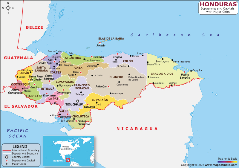
Honduras is a North American country situated between El Salvador to the southern front, Nicaragua to the southeastern front, Guatemala to the western front, and the Caribbean Sea to the northern front, with a population of approximately 10 million people.
History
The first inhabitants of Honduras were the Maya, who arrived in the region around 1500 BC. The Maya civilization thrived in the area until the arrival of the Spanish in the early 16th century. The Spanish colonization of Honduras began in 1524 when Hernán Cortés arrived in the region. Honduras became part of the Spanish Empire, and the indigenous population was forced into slavery and subjected to harsh treatment.
Honduras gained independence from Spain in 1821, along with other Central American countries. However, the newly formed nation struggled with political instability and economic underdevelopment for much of the 19th century. The country also faced significant challenges in the 20th century, including a military coup in 2009.
Culture
Honduras has a rich and diverse cultural heritage, influenced by its indigenous, Spanish, and African roots. Its people are known for their warm hospitality, and the country is home to a vibrant music scene and colorful traditional festivals.
Religion plays a significant role in Honduran culture, with the majority of the population identifying as Roman Catholic. However, there is also a significant Protestant population, as well as a growing Muslim community.
Language
The official language of Honduras is Spanish, which is spoken by the majority of the population. However, there are also many indigenous languages spoken in the country, including Garifuna, Miskito, and Lenca.
Geography
Honduras is a diverse country, with a range of different landscapes and ecosystems. The northern coast of Honduras is home to pristine beaches and coral reefs, making it a popular destination for tourists. The country is also home to several national parks, including the Cusuco National Park, which contains a diverse range of wildlife and vegetation.
Inland, Honduras is characterized by rugged mountain ranges and vast rainforests, which are home to a diverse range of flora and fauna. The country is also home to several large rivers, including the Ulua, which is the country's longest river.
| Official Name | Republic of Honduras |
| Capital | Tegucigalpa |
| Population | 9459440 |
| Area | 112,492 km2 |
| Currency | Lempira |
| Religion | Christianity |
| Language | Spanish |
| Major Cities | San Pedro Sula, Comayagua, La Ceiba |
FAQs
Q1: What is the capital of Honduras?
The capital of Honduras is Tegucigalpa. It is the largest city in the country and the political, cultural, and economic center of Honduras.
Q2: What currency is used in Honduras?
The currency of the nation is the Lempira. It is named after the 16th-century ruler of the Lenca people, Lempira, who led a resistance against the Spanish conquistadors.
Q3: What are some popular tourist destinations in Honduras?
Honduras has many popular tourist destinations, including the Bay Islands, which are known for their world-class scuba diving and snorkeling, the ancient ruins of Copan, the natural beauty of La Ceiba, and the picturesque town of Gracias.
Q4: What is the climate like in Honduras?
Honduras has a tropical climate, with temperatures generally ranging from 25-35 degrees Celsius (77-95 degrees Fahrenheit). The country has a rainy season from May to October, which can bring heavy rainfall and occasional hurricanes.
Last Updated on: April 04, 2023
