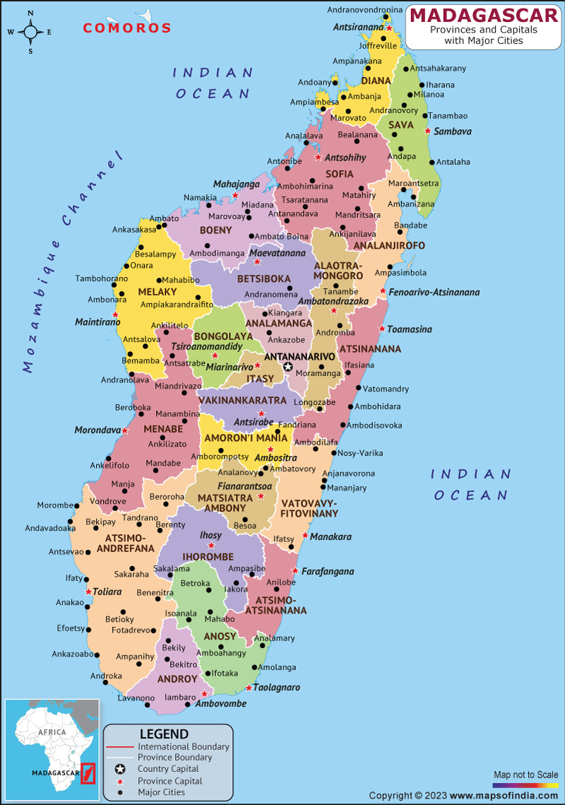
Madagascar is a sovereign island country in the Indian Ocean. Antananarivo is the largest city and capital of Madagascar. Madagascar is a member of the African Union, the United Nations, the Organisation Internationale de la Francophonie, and the Southern African Development Community. Agriculture and eco-tourism, along with increased investment in health, education and private enterprise, are key elements of its development strategy. Malagasy ethnic groups are often divided into different subgroups, of which the Merina of the central highlands is the largest one.
History:
Madagascar was ruled by a series of shifting socio-political alliances, Until the late 18th century. Since the early 19th century, much of it has been unified and ruled by a series of Merina nobles as the Kingdom of Madagascar. Madagascar ended its monarchy in 1897 after it was annexed by France, and Madagascar gained independence from France in 1960.
Since then, the country has gone through four major constitutional periods, known as a republic, and has operated as a constitutional democracy since 1992. After a political crisis and a military coup in 2009, Madagascar experienced a long transition to its fourth and current republic, returning to constitutional governance in January 2014.
Culture:
Each of Madagascar's many ethnic groups adheres to its own set of beliefs, customs and ways of life that have historically contributed to their distinct identities. Cultural elements shared across the island include male circumcision; strong family ties; a widespread belief in the power of magic, prophets, astrology, and wizards; and traditional social class divisions into nobles, commoners and slaves.
Language:
Malagasy is of Malayo-Polynesian origin and is commonly spoken throughout the island. The many dialects of Madagascar are generally mutually intelligible,[207] can be grouped into two subgroups: Eastern Malagasy and Western Malagasy.
Geography:
Madagascar lies between the longitudes 43 degrees and 51 degrees east, and latitudes 12 degrees and 26 degrees south. Neighbouring islands include the country of Mauritius and the French territory of Reunion to the east, and the French territory of Mayotte and the state of Comoros to the northwest. Along the east coast is a steep, narrow cliff that contains most of the island's remaining lowland rainforest. To the west of this ridge is a plateau in the centre of the island. To the west and south lies the rain shadow of the central highlands, home to dry broadleaf forests, spiny forests and deserts, and dry shrublands.
| Official name | Republic of Madagascar |
| Capital | Antananarivo |
| Population | 2.89 crores (2021) |
| Area | 587,041 sq km |
| Currency | Malagasy Ariary |
| Religion | Christian |
| Language | Malagasy and French |
| Major cities | Antananarivo, Toamasina, Antsirable |
FAQs
Q.1. what is the climatic condition of Madagascar?
Ans. The combination of southeast trade winds and northwest monsoon produces a warm rainy season, often accompanied by destructive cyclones, and a relatively cool dry season.
Q.2. What is the government structure of the country?
Ans. There exists a semi-presidential representative democratic multi-party republic in Madagascar.
Last Updated on: April 17, 2023
