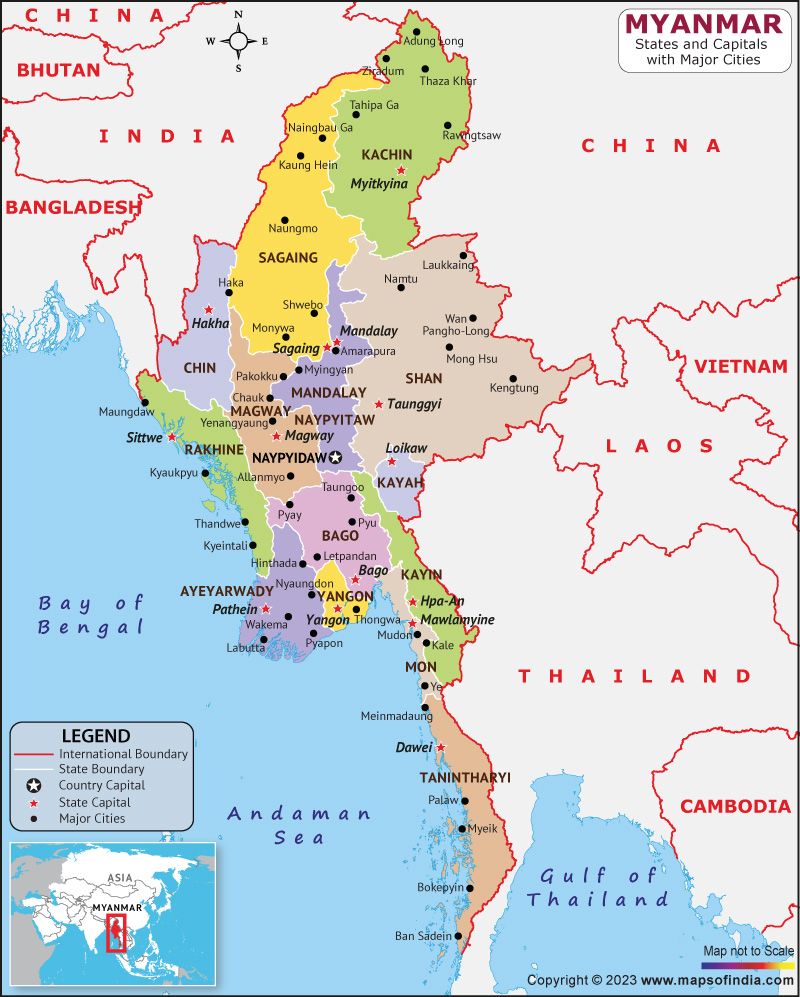
Myanmar is a country in Southeast Asia, which is also known as Burma. Myanmar is bordered by India and Bangladesh to the northwest, Laos and Thailand to the east and southeast, China to the northeast., and the Andaman Sea and the Bay of Bengal to its south and southwest. Myanmar is very rich in natural resources such as gems, jade, natural gas, oil, teak and other minerals.
History:
Early civilizations in the region include the Tibeto-Burmese-speaking Pyu city-states of Upper Myanmar and the Mon Kingdom of Lower Myanmar. At the beginning of the 19th century, the Gonbaung dynasty controlled the territory that included modern Myanmar and for a time also controlled Manipur and Assam. The British East India Company took control of Myanmar after three Anglo-Myanmar Wars in the 19th century, and Myanmar became a British colony. After a brief Japanese occupation, Myanmar was recaptured by Allied forces and gained independence in 1948. After the 1962 coup d'état, Burma became the military dictatorship of the Socialist Platform Party.
Culture:
Myanmar has many indigenous cultures, most of which are Buddhist and Bamar. Bamar's culture is influenced by those of neighbouring countries manifested in language, countries, cuisine, dance, music and theatre. The arts, especially literature, have historically been influenced by regional forms of Theravada Buddhism. The traditional temples, villages are the centre of cultural life.
Monks are respected and supported by the laity. Burmese culture is best seen in the villages where local festivals are held throughout the year, the most important of which is the Pagoda Festival.
Language:
Myanmar has four major language families that include Tai-kadai, Sino-Tibetan, Indo-European and Austro-Asiatic. Burmese, the official language and mother tongue of Bamar, is related to Chinese and Tibetan. It was written in a script consisting of circular and semicircular scripts borrowed from the Mon script, which developed from South Indian scripts in the 5th century.
Geography:
Myanmar lies between latitudes 9 degrees and 29 degrees North, and longitudes 92 degrees and 102 degrees East. Myanmar has a continuous coastline along the Andaman Sea and the Bay of Bengal to the south and southwest, occupying a quarter of its total circumference. Many mountains ranges such as Bago Yoma, Rakhine Yoma, Tenasserim Hills and Shan Hills exist in Myanmar, all of which run from north to south in the Himalayas. The valleys between the mountains contain fertile plains. Most of Myanmar's population lives in the Irrawaddy Valley, located between Mount Rakhine Yoma and the Shan Plateau.
| Official name | Republic of the Union of Myanmar |
| Capital | Naypyidaw |
| Population | 5.38 crores |
| Area | 676,578 sq km |
| Currency | Myanmar Kyat |
| Religion | Theravada Buddhists |
| Language | Burmese |
| Major cities | Naypyidaw, Bago, Yangon, Pathein |
FAQs
Q.1. What is the climatic condition of Myanmar?
Ans. Most of the country lies between the equator and the Tropic of Cancer. It is located in the monsoon region of Asia.
Q2: What is the Official name of Myanmar?
Ans. The official name of Myanmar is Republic of the Union of Myanmar.
Last Updated on: April 11, 2023
