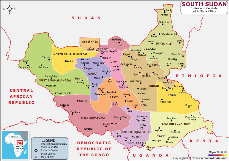
South Sudan is officially known as the Republic of South Sudan. Ethiopia, Sudan, the Democratic Republic of the Congo, Uganda, Kenya, and the Central African Republic are its neighbors. According to the Human Development Index, South Sudan is a developing nation that is 191st overall.
The capital and largest city of South Sudan is Juba. Sudan, Ethiopia, Kenya, Uganda, and the Democratic Republic of the Congo all border South Sudan on its northern, eastern, southern, and western borders, respectively. Several national parks and game reserves are found in South Sudan, including the southern Southern and Badingilo national parks.
History:
During the fifteenth and nineteenth centuries, many of the current ethnic groups in South Sudan made their homes there. The Sudan region in 1820, was full of slaves. Sudan was governed by the British and the Egyptians by the end of the nineteenth century. There was a dichotomy of development between the north and south in the country that persisted for several decades. Many governments over the years found it challenging to win the support of the nation's numerous political constituencies after Sudan gained independence in 1956, particularly in the south of Sudan.
The Comprehensive Peace Agreement (CPA) of 2005 led to the country of South Sudan announcing its independence on July 9, 2011. The CPA granted that, within six years, the country will hold an independence referendum.
Culture:
South Sudan's culture has been greatly influenced by its neighbors as a result of the lengthy civil war. Many South Sudanese who had fled the country ended up in Ethiopia, Kenya, and Uganda, where they interacted with the locals and picked up their languages and cultures.
Even when living in exile or the diaspora, most South Sudanese place a high value on knowing one's tribal origin, traditional culture, and dialect.
English, Swahili, Juba Arabic, their native African language, or a combination of all of these are used frequently by South Sudanese musicians.
Language:
There are more than 60 indigenous languages spoken in South Sudan, making it a multilingual nation. English, which was first spoken in the area during colonial times, is now the official language of the nation.
Dinka, Nuer, Bari, and Zande are some of the indigenous languages with the highest speaker populations. As a common language, Juba Arabic, an Arabic pidgin spoken by thousands of people primarily in the capital city of Juba, coexists with English.
Geography:
Between latitudes, 3° and 13°N and longitudes 24° and 36°E are where South Sudan is located. Swamps, grassland, and tropical forest are all present there. While traversing the nation, the White Nile passes through Juba.
The second-largest wildlife migration in the world takes place in South Sudan's protected Bandingilo National Park.
| Official name | Republic of South Sudan |
| Capital | Juba |
| Population | 1.07 crores |
| Area | 644,329 km² |
| Currency | South Sudanese pound |
| Religion | Christianity |
| Language | English |
| Major Cities | Juba, Bor, Wau |
FAQs
Q1.What is the official language of South Sudan?
English is the official language of South Sudan
Q2.What is the capital of South Sudan?
Juba is the capital of South Sudan.
Q3.What is the currency of South Sudan?
South Sudanese pound is the currency of South Sudan.
Q4.What is the climate in South Sudan?
An tropical climate prevails in South Sudan. Highs typically exceed 35°C, with average temperatures typically above 25°C, especially during the dry season.
Last Updated on: April 19, 2023
