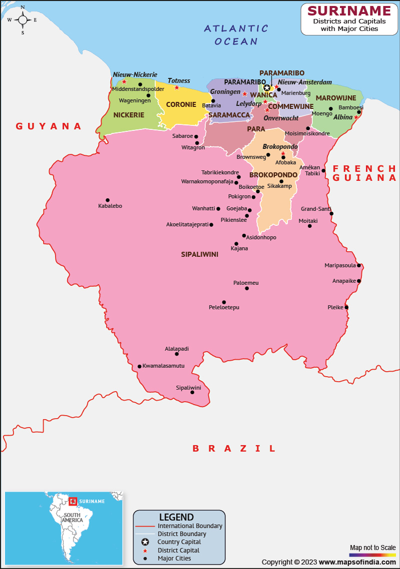
Suriname, officially known as the Republic of Suriname, is a small nation situated on the South American continent. It is bordered by Brazil to the southern front, French Guiana to the eastern front, Guyana to the western front, and the Atlantic Ocean to the northern front. Suriname is a multiethnic and multilingual country with a population of approximately 600,000 people.
History
Suriname's history dates back to pre-Columbian times when the area was inhabited by various indigenous peoples. The country was colonized by the Dutch in the 17th century, and it became a major exporter of sugar, coffee, and other crops. The country gained independence in 1975, and since then, it has struggled with political instability and economic challenges.
Culture
Suriname is known for its rich cultural heritage, which is a blend of African, Dutch, and indigenous cultures. The country has several ethnic groups, including the Afro-Surinamese, the Javanese, the Hindustani, and the indigenous peoples. Every tribe has its own distinctive traditions and practises.
Suriname's cuisine is influenced by its diverse population and is a mix of African, Indian, Indonesian, and Dutch dishes. Some popular Surinamese dishes include roti, a type of flatbread served with curry, and pom, a dish made with chicken or fish and cassava. Music and dance are also an essential part of Surinamese culture, with various styles of music and dance, including kaseko, kawina, and bazuin.Language
The official language of Suriname is Surinamese, a creole language based on Dutch, but many Surinamese people also speak Dutch, English, and other languages. The country has several indigenous languages, including Arawak, Carib, and Warao, which are spoken by indigenous peoples.
Geography
Suriname's geography is diverse, with the majority of the country covered in tropical rainforests. The country's coastline is approximately 386 kilometers long and is home to several beautiful beaches. The Suriname River, which runs through the country, is the primary means of transportation for many Surinamese people.
The country has a tropical climate with high humidity and temperatures that range from 26°C to 31°C. Suriname has two distinct seasons: a dry season from February to August and a wet season from September to January.
| Official Name | Republic of Suriname |
| Capital | Paramaribo |
| Population | 632638 |
| Area | 163,821 km2 |
| Currency | Surinamese Dollar |
| Religion | Christianity, Hinduism, Islam |
| Language | Surinamese, Dutch |
| Major Cities | Nieuw Nickerie, Nieuw Amsterdam, Albina |
FAQs
Question 1: What is the capital of Suriname?
Paramaribo serves as the nation's capital.
Question 2: What is the currency of Suriname?
The currency of the nation is the Surinamese dollar, abbreviated as SRD.
Question 3: What are some popular tourist attractions in Suriname?
Suriname is known for its ecotourism, and popular tourist attractions include the Central Suriname Nature Reserve, Brownsberg Nature Park, and the Galibi Nature Reserve, which is home to sea turtles.
Question 4: What is the population of Suriname?
The population of Suriname is estimated to be around 600,000 people, with the majority of the population living in and around the capital city of Paramaribo.
Last Updated on: April 27, 2023
