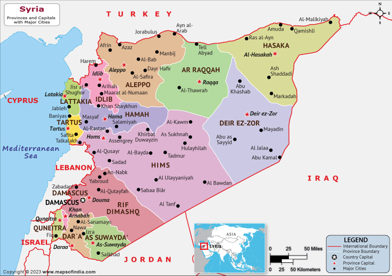
Syria, officially the Syrian Arab Republic, is a Western Asian nation. Fourteen governorates make up this unitary republic. 24 million people live in the nation, which has a total area of 185,180 km2. Syria is a land of fertile plains, mountains, and deserts. Ba'athism, an ideology that promotes Arab socialism and Arab nationalism, only exists in Syria as a form of government.
Damascus is Syria's largest and capital city. On the 2022 Corruption Perceptions Index, Syria was ranked second-to-last globally. Over 570,000 people have died in the Syrian civil war, which also caused an estimated 7.6 million people to be internally displaced as well as over 5 million refugees, which has made population estimates challenging in recent years. With more than 90% of the population living in poverty and 80% of Syrians experiencing food insecurity, the economic situation has also gotten worse as a result of the war.
History:
Despite political upheaval or turmoil, the conflict between different indigenous groups and foreign invaders led to cultural enrichment. Syria experienced a brief period of independence (1919–20) during the complex series of events that took place between the start of World War I and the League of Nations' granting of France's mandate over the country. Syria's short stint as an independent country came to an end, but it left behind a deep-seated animosity toward the West and a desire to bring all Arabs together in one state. Following its independence in 1946, Syria experienced decades of conflict and unrest over the direction of its government. This period was characterized by coups, countercoups, and sporadic civilian rule combined with army presence. Syria and Egypt were joined in the period from February 1958 to September 1961.
Culture:
Syria has a traditional culture and a long history. Dances like the al-Samah, the Dabkeh in all its iterations, and the sword dance are examples of how Syrians express their taste for traditional arts. The lively demonstration of folk customs occurs during marriage ceremonies and childbirths.
Language:
Arabic is the official language of the nation, and it has several regional variations. The country has 17 officially recognized dialects, including Kurdish, Mesopotamian Arabic, Aramaic, Armenian, etc.
Geography:
Between 32° and 38° N and 35° and 43° E are the latitudes and longitudes of Syria. The region's climate ranges from the humid Mediterranean coast, through a semiarid steppe region, to an arid desert in the east. The majority of the country is made up of an arid plateau, but the northwest region along the Mediterranean Sea is comparatively green. There are significant agricultural areas in the northeast in Al-Jazira and the south in Hawran. Syria's most significant river, the Euphrates, runs east-west through the nation.
| Official name | Syrian Arab Republic |
| Capital | Damascus |
| Population | 2.13 crores |
| Area | 185,180 km² |
| Currency | Syrian Pound |
| Religion | Islam |
| Language | Arabic |
| Major Cities | Aleppo, Damascus, Ar Raqqah |
FAQs
Q1 What is the official language of Syria?
Arabic is the official language of Syria
Q2 What is the capital of Syria?
Damascus is the capital of Syria.
Q3 What is the currency of Syria?
Syrian Pound is the currency of Syria.
Q4 What is the climate of Syria?
Syria mostly has a Mediterranean climate. Summers are typically very dry and have high rates of evaporation. The majority of the nation's summertime highs typically exceed 30°C.
Last Updated on: April 12, 2023, 2023
