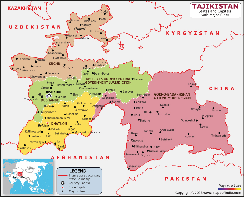
Tajikistan is a nation located in the Central Asian region of Asia. It is bordered by Kyrgyzstan to the northern front, Afghanistan to the southern front, China to the eastern front, and Uzbekistan to the western front. Tajikistan is known for its natural beauty, including its rugged mountains, pristine lakes, and vast deserts.
History:
Tajikistan has a rich and complex history that dates back thousands of years. The region has been inhabited since ancient times, and it has been ruled by various empires and kingdoms, including the Persian Empire, Alexander the Great, and the Mongols.
In the early 20th century, Tajikistan became part of the Soviet Union and experienced significant political and social changes. In 1991, in the aftermath of the dissolution of the Soviet Union, Tajikistan attained its independence.
Culture:
Tajikistan's culture is a blend of Persian, Russian, and Central Asian influences. The country's art, music, and cuisine reflect this diversity. Tajikistan is also home to a rich tradition of handicrafts, including pottery, embroidery, and carpet weaving.
Islam is the predominant religion in Tajikistan, with the majority of the population being Sunni Muslim. Tajikistan also has a significant population of Shia Muslims and a small minority of Christians and Jews.
Language:
The major language spoken in the nation is Tajik, which is a dialect of Persian. Russian is also widely spoken, especially in urban areas and among older generations. Tajikistan is also home to several other minority languages, including Uzbek and Kyrgyz.
Geography:
Tajikistan is a mountainous country that is part of the Pamir Mountains, also known as the "Roof of the World." The country is also home to the Vakhsh and Zeravshan mountain ranges. The highest peak in Tajikistan is Ismoil Somoni Peak, which stands at 7,495 meters. Tajikistan is also home to several rivers, including the Panj and Vakhsh rivers, which flow into the Amu Darya River.
| Official Name | Republic of Tajikistan |
| Capital | Dushanbe |
| Population | 9119347 |
| Area | 142,600 km2 |
| Currency | Somoni |
| Religion | Islam |
| Language | Tajik, Russian |
| Major Cities | Khujand, Bokhtar, Isfara |
FAQs
Q1:What is the highest point in Tajikistan and what is its significance?
The highest point in Tajikistan is Ismoil Somoni Peak (formerly known as Communism Peak), which stands at 7,495 meters. It is named after Ismoil Somoni, a 9th-century ruler who is considered the father of the Tajik nation.
Q2: What is the Pamir Highway and why is it significant?
The Pamir Highway is a 2,000 km road that stretches from Dushanbe, Tajikistan to Osh, Kyrgyzstan. It is considered one of the world's most scenic and challenging roads, as it winds through the Pamir Mountains and reaches altitudes of over 4,500 meters.
Q3: What is the significance of the ancient city of Penjikent?
Penjikent was a major city in the Sogdian civilization, which flourished in Central Asia from the 6th to the 11th centuries. The city was an important center of trade and culture, and its ruins are now a UNESCO World Heritage Site. Visitors can explore the city's ancient architecture, including its impressive fortifications, palaces, and temples.
Q4: What is the traditional dance of Tajikistan?
The traditional dance of Tajikistan is the Attan, which is performed at weddings, festivals, and other cultural events.
Last Updated on: April 12, 2023
