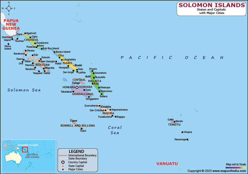
The Solomon Islands are a remote and beautiful country, located in the South Pacific Ocean. The country is made up of over 900 islands, with a total land area of approximately 28,400 square kilometers. Its tropical climate, stunning coral reefs, and dense rainforests make it a popular destination for travelers looking to explore the natural beauty of the region.
History:
The history of the Solomon Islands dates back over 30,000 years, with the first inhabitants believed to have arrived from Southeast Asia. Over time, the indigenous populations developed their own unique cultures and languages, with many of these traditions still celebrated today.
In the late 19th century, the Solomon Islands were colonized by the British, and the country remained a British protectorate until 1978 when it gained independence. During World War II, the Solomon Islands were the site of a major battle between the Allied forces and the Japanese, with many remnants of the war still visible today.
Culture:
The Solomon Islands are home to a rich and diverse cultural heritage, with many different indigenous groups living throughout the country. Traditional customs and practices, such as shell money, canoe building, and dancing, are still an important part of everyday life in many areas.
The arts are also an important aspect of Solomon Island culture, with music, dance, and storytelling playing a central role in many traditional celebrations. The country is also known for its intricate carvings, textiles, and jewelry, which often feature designs that reflect the natural world.
Language:
The Solomon Islands are home to over 70 different languages, making it one of the most linguistically diverse countries in the world. While English is the official language, many indigenous languages are still spoken throughout the country, particularly in rural areas.
Geography:
The Solomon Islands are located in the South Pacific Ocean, east of Papua New Guinea, and northeast of Australia. The country is made up of over 900 islands, with the majority of the population living on the main islands of Guadalcanal, Malaita, and Honiara.
The geography of the Solomon Islands is characterized by dense rainforests, stunning coral reefs, and beautiful beaches. The country is also known for its unique biodiversity, with many plant and animal species found only in the Solomon Islands.
| Official Name | Solomon Islands |
| Capital | Honiara |
| Population | 707851 |
| Area | 28,400 km2 |
| Currency | Solomon Islands Dollar |
| Religion | Christianity |
| Language | English |
| Major Cities | Malango, Auki, Gizo |
FAQs
Q1: What is the significance of the traditional shell money in Solomon Islands?
Shell money, also known as tabua, is an important aspect of the traditional culture of the Solomon Islands. It is made from shells, and was historically used as a form of currency, as well as for important ceremonies such as weddings and funerals.
Q2: What is the traditional diet of the Solomon Islands?
The traditional diet of the Solomon Islands consists mainly of fish, root vegetables, and tropical fruits. Coconut milk is also a common ingredient in many dishes.
Q3: What is the significance of the Kwai festival?
The Kwai festival is a traditional celebration that takes place in the Solomon Islands, particularly on the island of Malaita.
Q4: What is the traditional way of building canoes in the Solomon Islands?
Canoe building is an important part of the traditional culture of the Solomon Islands. The process involves using traditional tools and techniques to carve the canoe from a single log.
Last Updated on: April 19, 2023
