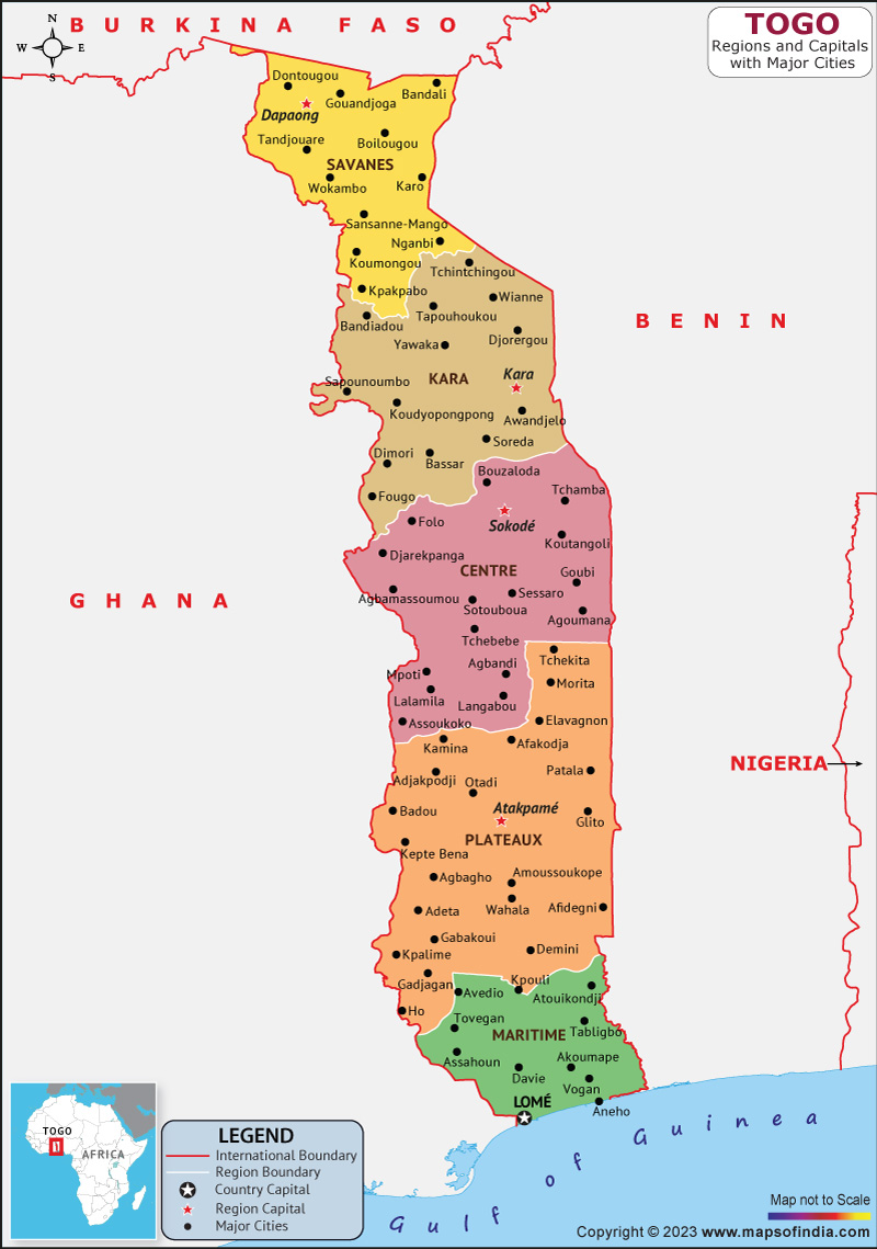
Togo, officially the Togolese Republic, is a nation in West Africa. Benin to the east, Ghana to the west, and Burkina Faso to the north are its neighbors. It has a surface area of about 57,000 square kilometers. The economy of Togo, a sub-Saharan country with a tropical climate, is primarily based on agriculture.
It continues southward to the Gulf of Guinea, where Lomé, the nation's capital, is situated. Togo is included in the group of least developed nations. As a commercial and trade hub for the area. It brings in food, petroleum products, machinery, and equipment. Agriculture and mining are essential to the economy.
History:
The name "The Slave Coast" was given to Togo and the surrounding area during the 16th to 18th centuries when the coastal area served as a trading hub for Europeans to buy slaves. Germany established Togo as a region in 1884, complete with a protectorate. France assumed control over Togo following World War I. With ease, Togo severed its constitutional ties to France on April 27, 1960, renounced its UN trusteeship, and established its provisional constitution with Olympio as president.
Culture:
The oral culture of the Togolese is very important. However, very little has been done to advance regional literature. A few Togolese authors used French before the country gained independence. Since independence, a variety of novelists and playwrights have contributed to the development of regional literature. The African Ballet of Togo aims to make the best traditional dances more widely known. The national library and archives of the nation are located in Lomé. Formerly the home of colonial-era rulers, the Palais de Lomé now houses a museum of modern art and a botanical garden. The largest ethnic groups in terms of population are the Ewe, Mina, Tem, Tchamba, and Kabre, whose influences can be seen in the culture.
Language:
The country has a total of 39 different official languages. French is the only official language out of the 39 spoken worldwide. In 1975, Ewé and Kabiyé were designated as national languages.
French is used in formal education, the legislative branch, all media, business, and administration. In the south, the ewe is a more widely spoken language. In some northern towns, tem serves as a limited-purpose trade language. Ewe and Kabiye are considered national languages in the Togo context, which refers to languages that are used in formal education and the media.
Geography:
The majority of its territories are located between latitudes 6° and 11°N and longitudes 0° and 2°E. Western Sudanian savanna, Guinean forest-savanna mosaic, and Eastern Guinean forests are the three terrestrial ecoregions found in Togo. Marshes and mangroves can be found along Togo's coastline.
| Official name | Togolese Republic |
| Capital | Lomé |
| Population | 86.4 lakhs |
| Area | 56,785 km² |
| Currency | CFA Franc |
| Language | French |
| Religion | Christianity |
| Major Cities | Lomé, Sokodé, Kara |
FAQs
Q1.What is the official language of Togo?
French is the official language of Togo.
Q2.What is the capital of Togo?
Lomé is the capital of Togo.
Q3.What is the currency of Togo?
CFA Franc is the currency of Togo.
Q4.what is the climate of Togo?
The country's southern region experiences humid weather, with an average annual temperature of 27°C. The temperature ranges from 17 to 41 degrees Celsius in the north.
Last Updated on: April 19, 2023
