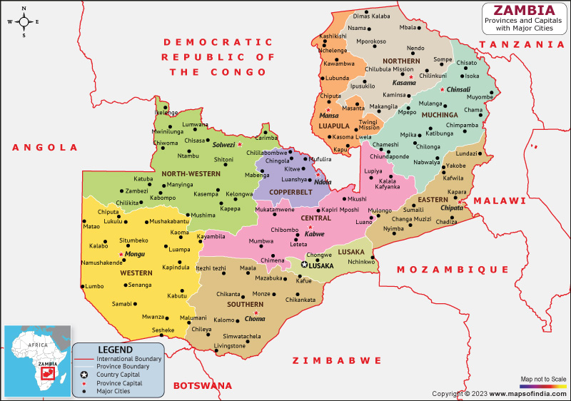
Zambia is a nation situated in southern Africa, bordered by Tanzania to the northeastern front, the Democratic Republic of the Congo to the northern front, Mozambique to the southeastern front, Zimbabwe to the southern front, Malawi to the eastern front, Botswana to the southwestern front, Namibia to the western front, and Angola to the northwestern front.
History:
Zambia's history dates back to prehistoric times, with evidence of human habitation in the region dating back over 100,000 years. The region was home to several powerful African empires, including the Bemba and Lozi kingdoms, before being colonized by the British in the late 19th century. Zambia gained independence from British rule in 1964, following a peaceful struggle for independence led by Kenneth Kaunda and the United National Independence Party (UNIP).
Culture:
Zambia's culture is a rich blend of traditional African customs and contemporary influences. The country is home to over 70 ethnic groups, each with its own unique traditions and cultural practices. Music and dance play an important role in Zambian culture, with traditional instruments such as the kalimba (thumb piano) and the ngoma (drum) being popular. Traditional arts and crafts, such as basket weaving and pottery, are also an important part of Zambian culture.
Language:
There are over 70 languages spoken in Zambia, with Bemba being the most widely spoken. English is also the official language of the country and is commonly used in government, education, and business.
Geography:
Zambia is a nation with a diverse landscape that includes savannas, forests, and wetlands. The country is home to several major rivers, including the Zambezi, Kafue, and Luangwa rivers, which are important for transportation, irrigation, and hydropower generation. Zambia is known for its natural beauty and is home to several national parks and wildlife reserves, including South Luangwa National Park, which is known for its wildlife and is a popular destination for safari tours.
| Official Name | Republic of Zambia |
| Capital | Lusaka |
| Population | 19610769 |
| Area | 752,617 km2 |
| Currency | Kwacha |
| Religion | Christianity |
| Language | English |
| Major Cities | Ndola, Kitwe, Chipata |
FAQs
Q1: What is the capital city of Zambia?
The capital city of Zambia is Lusaka, located in the southern part of the country.
Q2: What are some popular tourist attractions in Zambia?
Zambia is home to several popular tourist attractions, including Victoria Falls, which is one of the largest waterfalls in the world, South Luangwa National Park, which is known for its wildlife and is a popular destination for safari tours, and Lake Kariba, which is the world's largest man-made lake.
Q3: What languages are spoken in Zambia?
There are over 70 languages spoken in Zambia, with Bemba being the most widely spoken.
Q4: What is the political situation in Zambia?
The political system of Zambia is a presidential representative democratic republic. The President is both the head of state and head of government, and is elected by popular vote for a five-year term. The unicameral National Assembly consists of 156 members, with 150 members elected by popular vote and 6 members appointed by the President.
Last Updated on: April 19, 2023
