

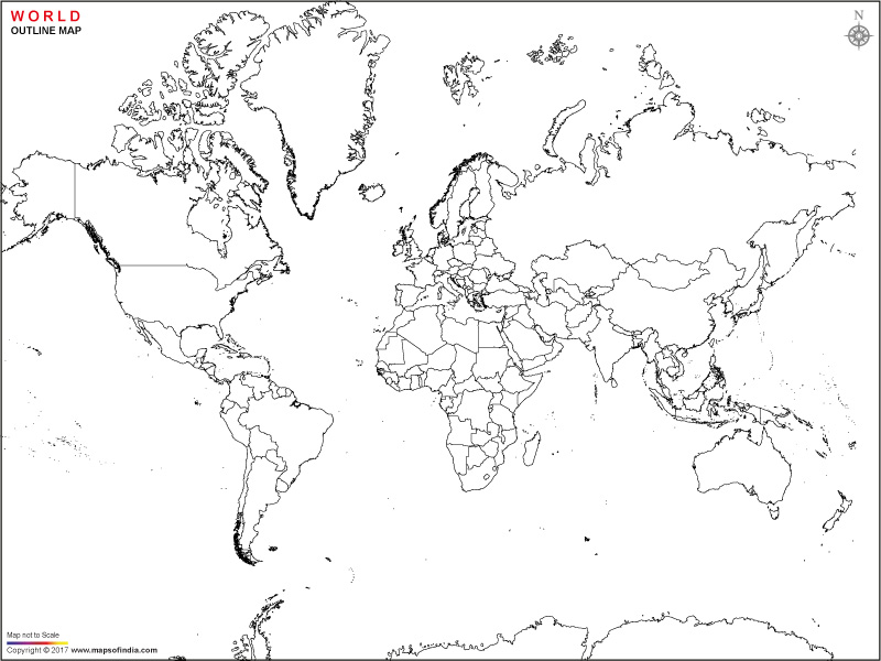





The world outline map displays the continents, the political boundaries of countries within those continents, and the lines of latitude and longitude. It provides a comprehensive overview of the world's geographical and cultural diversity. The printable world map is a useful practice and learning aid for school children. The children can color the different countries, continents, and oceans and enhance their knowledge of world geography.
The Continents
The continents which make up the landmass on Earth are: Africa, Asia, Europe, North America, South America, Australia, and Antarctica.
Asia
Asia is the largest and the most populous continent which has approximately 30% of the Earth's land area and nearly 59% of the world's population. The three large countries of Russia, China and India are part of Asia. Japan, Indonesia, North Korea, South Korea, Singapore, Malaysia, and the Philippines are some other countries in Asia. Some of the Middle East countries are Qatar, Iran, Iraq, Israel, Jordan and Kuwait. It extends from the Arctic Ocean in the north to the Indian Ocean in the south, and from the Pacific Ocean in the east to the Ural Mountains and the Caspian Sea in the west. Asia extends from approximately 11°S (Indonesia) to around 81°N (Russia). The continent extends from approximately 26°E (in the eastern part of Turkey) to about 169°W, crossing the 180° meridian through Russia's eastern territories.
It also has Mount Everest, the world's highest peak at 8,848.86 metres (29,031.7 feet) along with Tian Shan and Ural mountains. The Ural Mountains form the traditional boundary between Europe and Asia, while the Tian Shan is one of Central Asia's major mountain systems.
The longest river of Asia is Yangtze River which flows through China. The Tibetan Plateau, sometimes referred to as the "Roof of the World," is another part of Asia. It is Earth's largest and highest plateau.
Europe
Europe is the second smallest continent. It covers about 6.8% of the Earth's land area and accounts for approximately 9–10% of the world's population.
It extends from about 36°N (in southern Spain) to approximately 71°N (in northern Norway and parts of Russia). The continent stretches from approximately 25°W (in Portugal) to around 60°E (in western Russia).
Russia is the largest country in Europe and the Vatican City the smallest. Russia is spread over both Asia and Europe; the Ural Mountains divide its Asian and the European parts. Turkey too is considered both part of Asia and Europe. Some of the European countries are: Finland, Iceland, Bulgaria, Greece, Italy, Norway, France, Germany and the United Kingdom.
Alps and Carpathians are some of the significant mountain ranges. The Danube is the second-longest river in Europe, flowing through ten countries and vital for trade and transportation along with the Rhine river in Western Europe which is important for commerce, it flows through Switzerland, Germany, and the Netherlands. The Isle of Britain, which consists of Great Britain and Ireland, has a varied landscape and a rich cultural past. Scandinavian Islands, renowned for their striking scenery and active volcanoes, including Iceland and the Faroe Islands.
Africa
Africa is the second largest continent and has 20% of earth's total landmass and approximately 19% of world’s population. The Equator, cutting the earth at the center, passes through the continent making it a part of both the Northern and the Southern hemispheres.
The continent stretches from around 37°N (in Tunisia) to about 34°S (in South Africa), encompassing a variety of climate zones, from Mediterranean to tropical and arid. Africa extends from approximately 18°W (in western Senegal) to about 51°E (in eastern Somalia), covering several time zones and influencing diverse climatic conditions.
The Suez Canal separates Africa from Asia, and the Mediterranean Sea separates Africa from Europe. Algeria is the largest country in Africa, and Seychelles near the east coast, is one of the smallest sovereign island nations in Africa.
South Africa, Cameroon, Nigeria, Morocco, Congo, Botswana, Zimbabwe, Ghana, Burkina Faso, and Libya are some African countries. Kilimanjaro is Africa's highest peak at 5,895 meters (19,341 feet) which is located in Tanzania and famous for its snow-capped summit. Another important range was Atlas Mountains, stretching across Morocco, Algeria, and Tunisia, these mountains are vital for local ecosystems and climates.
Sahara Desert is the largest hot desert in the world, spanning over 9 million square kilometers (3.5 million square miles) and it covers much of North Africa and features harsh, arid conditions. Kalahari Desert is another notable desert located in Southern Africa, it is a semi-arid sandy savanna known for its wildlife and indigenous cultures. The longest river in the world also flows here. Flowing over 6,650 kilometers (4,135 miles) through eleven countries, it has been crucial for agriculture and civilization. The continent is also home to one of the deepest lakes in the world known as Lake Tanganyika is located in East Africa, it is rich in biodiversity and a key resource for local communities.
North America
North America, the third-largest continent. It comprises about 16.5% of the Earth’s land area and is home to more than 600 million people. The continent spans from about 15°N (in the southern part of Mexico) to approximately 71°N (in northern Canada and Alaska). There are arctic, temperate, and tropical climates within this range of temperatures.
North America extends from around 11°W (in Greenland) to about 180°W (in the Aleutian Islands of Alaska), covering several time zones and various geographical features. North America is part of the Northern and Western Hemispheres. The main countries here are the United States of America, Canada and Mexico. Caribbean islands are also part of North America. Some of the other countries are: Panama, Cuba, and Costa Rica.
Stretching from Canada to New Mexico, Rocky mountains are known for their rugged terrain and significant biodiversity. The Appalachian Mountains are located in the eastern United States, this range is one of the oldest in North America, with lush forests and rich wildlife. The Colorado River, known for carving the Grand Canyon, flows through several states of North America. This river is also vital for water supply in the arid Southwest region. The Mississippi River, which is one of the longest rivers in the world, flows over 3,700 kilometers (2,300 miles) through the central United States, playing a crucial role in trade and agriculture.
South America
South America, the fourth largest continent. Covering approximately 17.84 million square kilometers (6.89 million square miles), it accounts for about 12% of the Earth’s total land area and is home to over 430 million people.
The continent extends from about 12°N (in northern Colombia) to around 55°S (in southern Chile and Argentina), incorporating a variety of climate zones, from tropical in the north to polar in the south. South America stretches from approximately 35°W (in eastern Brazil) to about 81°W (in western Peru). South America is divided from North America by the Panama Canal.
Brazil is the largest country and the most populous. Some of the other countries in South America are: Argentina, Bolivia, Colombia, Peru, Paraguay, and Guyana. The world's longest continental mountain range is the Andes Mountains. The Amazon River is the largest river in the world in terms of discharge volume which runs through Brazil and a number of its neighbors for over 6,400 kilometers. It is vital to the environment and economy of the area. Another major river is Rio Paraná which is one of the longest rivers in South America, it flows through Brazil, Paraguay, and Argentina, forming part of the border between Paraguay and Argentina.
Amazon Rainforest, covering a vast area of over 5.5 million square kilometers (2.1 million square miles), is the largest rainforest in the world, hosting an unparalleled diversity of wildlife and plant species. One of the driest spots on Earth is the Atacama Desert, which is found in northern Chile and is distinguished by its unusual topography and salt flats.
Australia
Australia, the smallest continent and the sixth-largest country. Covering approximately 7.69 million square kilometers (2.97 million square miles), Australia is both a country and a continent, often referred to as "Oz".
Australia extends from about 10°S (in the northern tip at Cape York) to approximately 43°S (in Tasmania), showcasing a range of climates from tropical in the north to temperate in the south. The continent stretches from about 113°E (in Western Australia) to approximately 153°E (in the eastern part of Queensland). Australia is the only continent which is also a country.
The island country of New Zealand is considered a part of the continent. The small scattered islands in the Pacific Ocean are considered part of the Australia Oceania continent. Simpson Desert is famous for its red sand dunes, it is located in the Northern Territory and South Australia. Australia’s highest peak is Mount Kosciuszko, at 2,228 meters this range features alpine environments. Great Barrier Reef is the largest coral reef system in the world, located off the coast of Queensland, it is also a UNESCO World Heritage site. The continent's largest lake - Lake Eyre, is located in South Australia.
Antarctica
Antarctica is the world's coldest and highest continent, and about 98% of it is covered by a massive ice sheet. Antarctica has no permanent human settlements on it, though the surrounding seas of Antarctica are home to fish and mammals. Teams of scientists from various countries visit it periodically to study the wildlife and the landscape.
The continent contains nearly 70% of the Earth's freshwater, stored in its vast ice sheets, making it one of the most important regions for climate research.
FAQs
Q1: What is a world outline map?
A world outline map is a simplified map that shows the outlines of continents, countries, and major geographical boundaries without detailed physical features. It is commonly used for learning, practice, and map-based activities.
Q2: What are the seven continents shown on a world outline map?
The seven continents shown on a world outline map are Asia, Africa, Europe, North America, South America, Australia, and Antarctica.
Q3: What is the purpose of a printable world outline map?
A printable world outline map helps students, teachers, and geography enthusiasts identify countries, continents, oceans, and political boundaries. It is also useful for classroom activities, quizzes, and coloring exercises.
Q4: Which is the largest continent on the world outline map?
Asia is the largest continent by land area and also the most populous continent in the world.
Q5: Which is the smallest continent shown on the world outline map?
Australia is the smallest continent by land area and is also the only continent that is a single country.
Q6: Why is Antarctica included on a world outline map?
Antarctica is one of the seven continents and is included to provide a complete representation of the Earth's landmasses. It is primarily used for scientific research and has no permanent human population.
Q7: What is the difference between a world outline map and a political world map?
A world outline map primarily shows the outlines of countries and continents with minimal details, while a political world map includes country names, capitals, boundaries, and other administrative information.
Last Updated on: July 02, 2026


