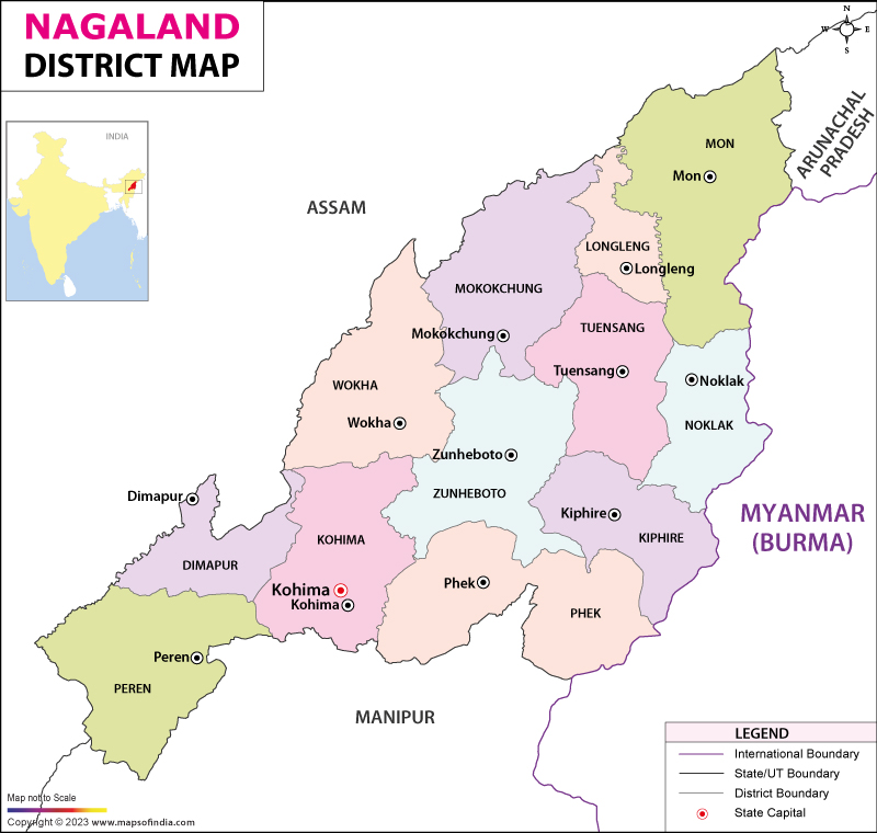
Nagaland is a state in the far north east of India. The state is largely mountainous and Mount Saramati, at a height of 3,840 meters is the highest peak in the state.
Agriculture is the most important economic activity of Nagalang and primary crops of the region are rice, corn, millets, pulses, tobacco, oilseeds, sugarcane and potatoes. Other activities contributing to the economy of the state are forestry, tourism, insurance and real estate. The population of Nagaland is 1,980,602 (2011 census) and the state covers an area of 16,579 km sq.
Districts and Administration of Nagaland: Nagaland has eleven districts which are governed by a district magistrate or a Deputy Commissioner, an officer from the Indian Administrative Service, who is responsible for the smooth running of the district and is assisted by a number of officials belonging to different sections of the administrative services. A Superintendent of Police, who is from the Indian Police Service, is responsible for the law and order situation in the district.
Tourism in Nagaland: Nagaland has a lot to offer tourists and is famous for the Hornbill Festival, held every December. This week long festival is held at the Naga Heritage Village, Kisama, which is around 12 km from Kohima. Other tourist attractions in Nagaland are Touphema Tourist Village, Dzukou Valley and Kohima the state capital, which is known for housing the largest crucifix in Asia.
List of Districts in Nagaland
Last Updated on: January 14, 2026
Agriculture is the most important economic activity of Nagalang and primary crops of the region are rice, corn, millets, pulses, tobacco, oilseeds, sugarcane and potatoes. Other activities contributing to the economy of the state are forestry, tourism, insurance and real estate. The population of Nagaland is 1,980,602 (2011 census) and the state covers an area of 16,579 km sq.
Districts and Administration of Nagaland: Nagaland has eleven districts which are governed by a district magistrate or a Deputy Commissioner, an officer from the Indian Administrative Service, who is responsible for the smooth running of the district and is assisted by a number of officials belonging to different sections of the administrative services. A Superintendent of Police, who is from the Indian Police Service, is responsible for the law and order situation in the district.
Tourism in Nagaland: Nagaland has a lot to offer tourists and is famous for the Hornbill Festival, held every December. This week long festival is held at the Naga Heritage Village, Kisama, which is around 12 km from Kohima. Other tourist attractions in Nagaland are Touphema Tourist Village, Dzukou Valley and Kohima the state capital, which is known for housing the largest crucifix in Asia.
List of Districts in Nagaland
| S No. | District | Headquarters | Population (Census 2011) | Sex Ratio (per 1000) | Average Literacy |
|---|---|---|---|---|---|
| 1 | Dimapur | Dimapur | 378,811 | 919 | 84.79% |
| 2 | Kiphire | Kiphire | 74,004 | 956 | 69.54% |
| 3 | Kohima | Kohima | 267,988 | 928 | 85.23% |
| 4 | Longleng | Longleng | 50,484 | 905 | 72.17% |
| 5 | Mokokchung | Mokokchung | 194,622 | 925 | 91.62% |
| 6 | Mon | Mon | 250,260 | 899 | 56.99% |
| 7 | Peren | Peren | 95,219 | 915 | 77.95% |
| 8 | Phek | Phek | 163,418 | 951 | 78.05% |
| 9 | Tuensang | Tuensang | 196,596 | 929 | 73.08% |
| 10 | Wokha | Wokha | 166,343 | 968 | 87.69% |
| 11 | Zunheboto | Zunheboto | 140,757 | 976 | 85.26% |
Last Updated on: January 14, 2026
