|
|||||
 | |||||
|
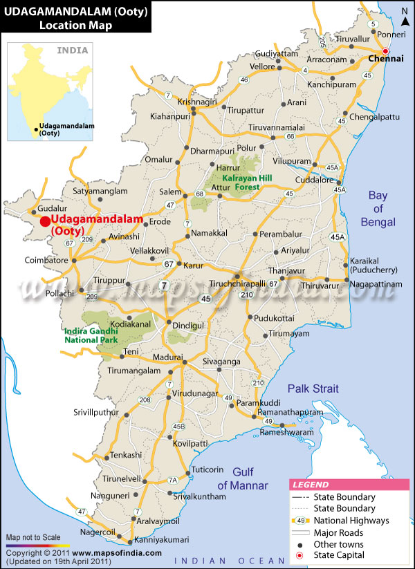
*The Map showing the Location of Ooty (Udhagamandalam) In Tamilnadu and India.
Disclaimer: All efforts have been made to make this image accurate. However Mapping Digiworld Pvt Ltd and its directors do not own any responsibility for the correctness or authenticity of the same.
Disclaimer: All efforts have been made to make this image accurate. However Mapping Digiworld Pvt Ltd and its directors do not own any responsibility for the correctness or authenticity of the same.
The beautiful hill station of Ooty is located in the Nilgiri district of Tamil Nadu. The most fascinating aspect of Ooty location is that the hill town is surrounded by four magnificent hills belonging to the Nilgiri range.
The latitudinal position of Ooty is 11 degrees and 24 minutes north and the longitudinal position of this hill station is 76 degrees and 42 minutes east. Ooty is situated about 2213 meters above sea level.
The four beautiful ranges amidst which the hill resort of Ooty stands are Snowdon, Elk Hill, Doddabetta and Club Hill. This picturesque location of Ooty attracts many tourists to this place. It is situated in a place where the Eastern Ghats meet the Western Ghats.
The nearest airport to Ooty is the one located in Coimbatore. It is about 89 kilometers away from this hill station. This air junction is connected to important cities such as Calicut, Mumbai, Madurai and Chennai by Indian Airlines flights.
The hill station of Ooty is connected by narrow guage trains to Mettupalayam. It is in turn connected to all the major cities of India through Coimbatore and Chennai.
The hill station of Ooty is well connected to other important places by a good network of roads. It is situated at a distance of 178 kilometers from Calicut and 160 kilometers from Mysore. The distance of Ooty from 535 kilometers.
The strategic Ooty location near the important city of Coimbatore has made the hill station easily accessible and that facilitates tourism.
Last Updated on 9/20/2011
The four beautiful ranges amidst which the hill resort of Ooty stands are Snowdon, Elk Hill, Doddabetta and Club Hill. This picturesque location of Ooty attracts many tourists to this place. It is situated in a place where the Eastern Ghats meet the Western Ghats.
The nearest airport to Ooty is the one located in Coimbatore. It is about 89 kilometers away from this hill station. This air junction is connected to important cities such as Calicut, Mumbai, Madurai and Chennai by Indian Airlines flights.
The hill station of Ooty is well connected to other important places by a good network of roads. It is situated at a distance of 178 kilometers from Calicut and 160 kilometers from Mysore. The distance of Ooty from 535 kilometers.
The strategic Ooty location near the important city of Coimbatore has made the hill station easily accessible and that facilitates tourism.
Last Updated on 9/20/2011
Ooty Map
