Tripura Tourism
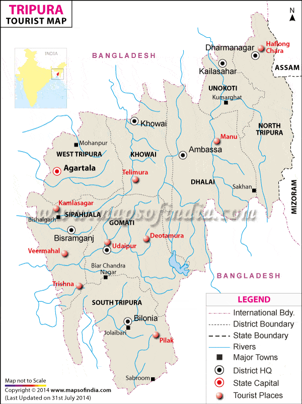
Tripura is the second smallest state in India. The place traces it past even in the age of the Mahabharata. The popular belief is that the name originates from "Tripura Sundari" - the presiding deity of the land.
Tripura was formerly ruled by Maharajas of Manikya dynasty. With the Independence in 1947, the kingdom merged with India and in 1972 got the statehood.
| Location | In the northeastern part of India Bangladesh on the north, west, south and south-east Assam and Mizoram in the east |
| Latitude | Between 22°56' and 24°32' North |
| Longitude | Between 90°09' and 92°20' East |
| Area | 10492Sq.Km |
| Climate | Summer - Hot Winter - Cold |
| Max Temperature | 36°C |
| Min Temperature | 7°C |
| Average Annual Rainfall | 210 cm |
| Capital | Agartala |
| Population | 3191168 |
| Languages | Bengali, Kok Borok, Chakma, Manipuri, Hindi and English |
| Religion | Hinduism, Buddhism, Tribal religions |
| Best Time to Visit | September to March |
| Clothing | Summer - Cottons Winter - Woolens |
How to Reach Tripura
Tripura is cast away in the northeastern India. Though small, the state is charmingly beautiful. Tripura, as a sum total of old Buddhist shrines and Hindu temples, wild life habitats replete in exotic flora and fauna and vibrant composition of several tribes, exudes an unexplored charm.
By Air
The main airport of the state is located in Agartala the state capital. Many public and private airlines operate regular flights to and from Agartala. From Kolkata and Guwahati it takes less than 45 minutes to reach Tripura by air. The state has 3 more airports in Khowai, Kamalpur and Kailashahar where small chartered-planes can land easily.
By Road
National Highway No.44 connects Agartala to Guwahati via Shillong in 24 hours. But the location of the state makes it more convenient to reach Tripura from Bangladesh by road.
By Train
Kumarghat is the nearest railhead, which is at a distance of 140 Km. away from Agartala. Kumarghat is linked by railways to Guwahati, which is in turn connected to the rest of the country. One can approach Guwahati from most major railway stations in India.
Shopping in Tripura
Tribal populated Tripura boasts of vast forestland where bamboo and cane grow in abundance. These two factors have played a key role in forming a tradition of fantastic handicrafts in the state, which make shopping in Tripura a delight.
The ethnic groups of Tripura fashion out various utility items and objets d'art from cane, bamboo and woods. Alongside, clay, wood, palm leaves are also favorite medium for handicrafts. But the artifacts and furniture made by Tripura artisans rank among the best in the country for their beauty, elegance and exquisite designs.
The state capital Agartala is the best place for shopping in Tripura. You can also opt for visiting the tribal villages to see the craftsmen at work and can shop from them.
As in all other states, you would find host of Government run emporia and private shops for shopping in Tripura. The colorful bazaars with the assortment of variegated artifacts provide visual delight. No wonder if you come across a mixed bag of specialties of Manipur, Mizoram, Meghalaya and so on since these north eastern states also have a rich tradition of art and crafts.
Flights to Tripura
|
|

