In GIS attribute data is described as the characteristic of map feature. Attribute data are stored in tables. Each row of a table represents map feature and each column represents a characteristics. The intersection of a column and row shows the value of particular characteristics for a particular map feature.
ATTRIBUTE DATA MODELS
A separate data model is used in GIS to store and maintain attribute data. These data models may exist internally within the GIS software(DBMS). A variety of different data models exist for this storage and management of attribute data. The most common are:The tabular model is the manner in which most early GIS software packages stored their attribute data. The next three models are those most commonly implemented in database management system(DBMS). The object oriented is newer but rapidly gaining popularity for some application. A brief review of each model is given below.
Tabular Model: -The simple tabular model stores attribute data as sequential data files with fixed formats. This type of data model is outdated in GIS arena. It lacks any method of checking data integrity, as well as being inefficient with respect to data storage.
| CODE | STATE | DISTRICT |
| 665 | Haryana | Mewat |
| 764 | Punjab | Amritsar |
| 245 | Punjab | Kapurthala |
| 535 | Uttar Pradesh | Meerut |
| 355 | Haryana | Ambala |
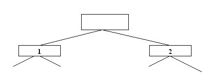
Hierarchical Model: -The hierarchical database organizes data in a tree structure. Data is structured downward in a hierarchy of tables. Any level in the hierarchy can have unlimited children, but any child can have only one parent. Hierarchical DBMS have not gained any noticeable acceptance for use within GIS. They are oriented for data sets that are very stable, where primary relationship among the data change frequently or never at all. Also, the limitation on the number of parents that an element may have is not always conducive to actual geographic phenomenon.
Network Model: -The network database organizes data in a network or plex structure. Any column in a plex structure can be linked to any other like a tree structure. a plex structure can be described in terms of parents and children. This model allows having more than one parent. Network DBMS have found not much more acceptance in GIS than the hierarchical DBMS. They have the same flexibility limitations as hierarchical database: however, the more powerful structure for representing data relationships allows a more realistic modeling of geographic phenomena. However network database tend to become overlay complex too easily. In this regard it is easy to lose control and understanding of the relationships between elements.

Relational Model: - The relational database organizes data in tables. Each table is identified by a unique table name, and is organized by rows and columns. Each column within a table also has a unique name. Columns store the values for a specific attribute, e.g. cover group, tree height. Rows represent one record in the table. In GIS each row is usually linked to a separate feature, e.g. a forestry stand. Accordingly, each row would be comprised of several columns, each column containing a specific value for that geographic feature. In this model a key represents one or more attributes whose value can uniquely identify a record in a table. Therefore, a key common to two tables can establish connection between corresponding records in the tables.
A relational database usually contains three types 0f relationship between tables. Usually here two types of table are defined- the source table & the destination table. If the purpose is to add attribute data from a table to the feature attribute table, then the feature attribute table is the destination table and the other one is the source table. Owing ot this manner, three types of relationships can be created.
One-to-one Relationship- Here one and only one record in the destination table is related to one and only one record in the source table.
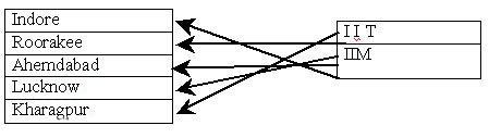
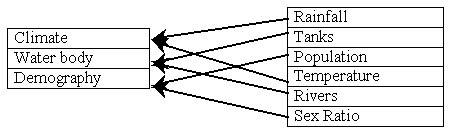
One-to-Many Relationship- This means that one record in the destination table may be related to more than one record in the source table.
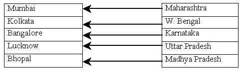
Many-to-One Relationship- This type of relationship is just opposite to the One-to-Many Relationship. Here two or more records in the destination table may be related to one record in the source table.
Object Oriented Model: - The object oriented data model manages data through object. An object is a collection of data elements and operations that together are considered as single entity. The object oriented database is a relatively new model. This approach has the attraction that querying is very natural, as features can be bundled together with attributes at the database. Today, only a few GIS packages are promoting the use of this attribute data model. However, initial impressions indicate that this approach may hold many operational benefits with respect to geographic data processing.