Northern India Map

Northern India Map
Northern India Map
Email   Buy Now
Disclaimer: All efforts have been made to make this image accurate. However Mapping Digiworld Pvt Ltd and its directors do not own any responsibility for the correctness or authenticity of the same.


North India is a well-defined region of the northern part of India. The Indus-Gangetic Plain and the Himalayas are the important geographical features of this region and delimitate it from the Central Asia and the Tibetan Plateau. The states that are officially a part of the northern region of India are Jammu and Kashmir, Punjab, Himachal Pradesh, Uttar Pradesh, Uttarakhand and the union territories of Delhi and Chandigarh. States like Rajasthan, Madhya Pradesh and Bihar are not formally part of North India but indirectly considered a part of the region.


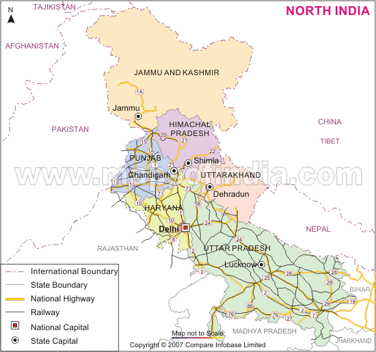
North India was the historical centre for many empires including the Guptas, the Mauryas, the Mughals, the British, the Sikh empire and many more. There are many pilgrim centres and heritage sites in North India such as Char Dham, Vaishno Devi, Golden Temple, Taj Mahal, Red Fort, Humayun's Tomb and many more.

You can see the above map to know more about North India. The above map shows the states that are part of the northern region. The major states that are a part of the region are marked in different colours. The state and international boundaries are also marked on the map. The capital cities of the states are also shown. The national highways passing through the states are marked with yellow lines, while the black-coloured lines highlight the railway networks in the region.

WBST300615
WBVDA


Last Updated on : July 8, 2015

 
  Buy this Map