| Click on the Map for Bigger Map |
 |
About Daman and Diu
This Union Territory of the Indian sub-continent was ruled by the Portuguese for more than 450 years. This place, along with Dadra and Nagar Haveli as well as Goa , was included in the Indian Republic on 19th December of the year 1961. The region is said to have one of the perfect blends of culture, belief, good idea and ancient civilization. The official languages of this Union Territory are as follows:
- Marathi
- Hindi
- Gujarati
- English
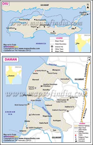
Location of Daman and Diu
With its geographical location at the latitude of 20° 25' N and the longitude of 72° 50' E, this Indian Union Territory accounts for approximately 112 sq. km. of the total land surface of the country as well as the earth. Located on the coastal area of the Arabian Sea, this Union Territory of India is comprised of the following 2 districts:
- Daman District: This district of the territory of Daman and Diu covers a land area of around 40 sq. km. The major settlement of this district is based in the town.
- Diu District: Spread over an area of about 72 sq. km., the main dwellings of this district are based in the Daman city.
How to Reach Daman and Diu
This territory of India is well connected to the rest of the nation through the following modes of transportation:
- By Airways: The nearest airports to this city are the ones, which are located in the city of Mumbai such as the Santa Cruz Domestic Airport and the Chattrapathi Shivaji International Airport. Flights plying from these 2 Mumbai airports connect the region to a number of national as well as international destinations.
- By Railways: The nearby railway station to this Indian Territory is based at Vapi that is around 12 km from the heart of the territory. Situated on the main line, in between the major Indian cities of Mumbai and Delhi , this is among the busiest railway station in the place. Almost all the mail trains, the express trains as well as the local trains on this line of the Indian Railways stop at this station. The other railway station that serves the area is the Valsad Junction, which is about 35 km away from the territory.
- By Roadways: Proximity to the National Highway - 8 that runs in between Ahmedabad in Gujarat and Mumbai in Maharashtra helps the territory maintain a good road link with some of the important cities, which are located towards the western part of the country. However, most of the routes go through Vapi. Let us have a quick glance at the distance in between Daman and Diu and some major cities in the nation as provided in the table below:
| Sl. No. | Name of the city | Distance from Daman and Diu |
|---|---|---|
| 1 | Ahmedabad | 367 Km |
| 2 | Diu | 763 Km |
| 3 | Mumbai | 193 Km |
| 4 | Panaji in Goa (Via Mumbai) | 787 Km |
Places to Visit in Daman and Diu
The different hill stations along with their natural beauty make the place worth visiting. This territory of west India has not got innumerable places to see though. However, to name a few of the tourist attractions, which are located in and around it, are categorized below:
pta Prayag in Delwada
Places of Worship in Daman and Diu
- Bom Jesus Church
- Gangeshwar Temple
- Our Lady of Rosary Chapel (Within the premises of the Moti Daman Fort)
- Our Lady of Sea Church (Within Nani Daman Fort)
- Somnath Temple
Sea Beaches in Daman and Diu
- Devka Beach
- Jampore Beach
- Nagao Beach
Other Tourist Attractions in Daman and Diu
- Bridge Side Garden
- Children Park
- Girnar Hill
- Hathi Park
- Hilsa Aquarium
- Kachigam Water Tank
- Shaking Tower in Delwada
Daman and Diu State Information | |
|---|---|
| Capital | Daman |
| Date of forniation | 30. May. 1987 |
| Administrator | Satya Gopal |
| Tourist attractions | Somnath Mahadev Temple, Devka Beach, Diu Fort, Panikotha, Nagoa Beach |
| Festivals | Gangaji Fair, Holi, Diwali |
| Languages | Gujarati, Marathi |
| Size | 111 sq. km |
| Population (Census 2011) | 243,247 |
| Rivers | Damanganga, Kolak, Kalai |
| Major crops | Paddy, ragi, groundnut, pulses |
| Factoids | Daman was once a part of the Kushana Empire. |
| The ancient river Damanganga lends its name to the region of Daman. | |
| No. of District | 2 |
List of Districts in Daman and Diu
| Sr. No. | District | District HQ | Population (2011) | Growth | Sex Ratio | Literacy | Area (km2) | Density (/km2) |
|---|---|---|---|---|---|---|---|---|
| 1 | Daman | Daman | 191173 | 67.71% | 534 | 88.07 | 72 | 2651 |
| 2 | Diu | Diu | 52074 | 17.77% | 1031 | 83.46 | 40 | 1301 |
| Union Territories of India |
Last Updated on: April 17, 2026
Travel to Daman Diu