


 |
 |  |  |  |
| Location Map | District Map | River Map | Road Map | Rail Network Map |
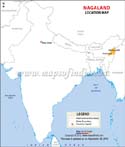
Nagaland was established on December 1, 1963, amid the mountains and valleys of the northeastern part of the nation, encircled by Manipur to the south, Assam to the west, Arunachal Pradesh to the north, and the Sagaing Region of Myanmar to the east as illustrated on the nagaland map. Nagaland's capital city is Kohima.
According to the 2011 Census of the nation, it has a land area of 16,579 km2 (6,401 sq mi) and a population of 19.8 Lakh people. It is one of India's smallest states.
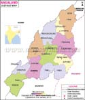
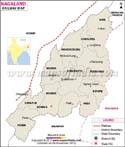
Nagaland was formed in 1963 with only three districts: Mokokchung District, Tuensang District, and Kohima District, That number expanded to seven in the year 1973, eleven in the year 2004, and the latest districts founded, Niuland District, Chümoukedima District, and Tseminyü District in 2021, and Shamator District in 2022, raised the total to sixteen.
Last Updated on : June 24, 2026
According to the 2011 Census of the nation, it has a land area of 16,579 km2 (6,401 sq mi) and a population of 19.8 Lakh people. It is one of India's smallest states.
Nagaland was formed in 1963 with only three districts: Mokokchung District, Tuensang District, and Kohima District, That number expanded to seven in the year 1973, eleven in the year 2004, and the latest districts founded, Niuland District, Chümoukedima District, and Tseminyü District in 2021, and Shamator District in 2022, raised the total to sixteen.
| Nagaland State Information (As per Nagaland Map) | |
|---|---|
| Capital | Kohima |
| Date of Formation | Dec. 01, 1963 |
| Governor | La. Ganesan |
| Chief Minister | Neiphiu Rio |
| Festivals | Moatsu harvest festival, Selu-enyi, Sankarni |
| Major dance and music forms | Nruirolians (Cock dance), Temangnetin (Fly dance) |
| Arts and crafts | Naga baskets; cup violin made using bamboo and a gourd; bamboo trumpet |
| Languages | Ao, Sema, Konyak, Angami, Chakhesang, Chang, Khiamniungan, Kuki |
| Size | 16,579 km2 (6,401 sq mi) |
| Population (Census 2011) | 1980602 |
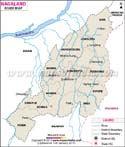
| Rivers | Milak, Barak, Dhansiri, Bhogdoi, Kushiyara, and so on |
| Forests and wildlife sanctuaries | Ntanki National Park |
| State animal | Gayal |
| State bird | Blyth's tragopan |
| State flower | Rhododendron arboreum |
| State tree | Alnus nepalensis |
| Major crops | Rice, maize, millet, rubber |
| No. of District | 16 |
Last Updated on : June 24, 2026