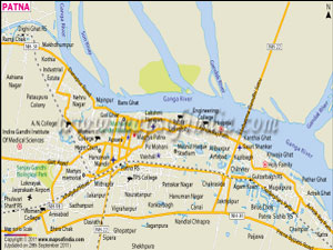
| Click opn the Map for Bigger Map. |
 |
Where is Patna?
Patna is an important city in Eastern India. The coordinates of Patna are 25°36'40? North and 85°08'38? East. The contemporary city lies on the southern riverbanks of the Ganges. Patna maps, Bihar show that important rivers of the state such as Gandak, Sone, and Punpun also flow across the city. The length of the city is about 35 km and the breadth of the city is about 16-18 km.
What makes Patna famous?
Patna is a popular religious destination since the sacred Hindu, Buddhist, and Jain hubs of Rajgir, Vaishali, Bodh Gaya, Nalanda, and Pawapuri are closely located to the city. In addition, the city is a holy place for Sikhs since it is the birthplace of Guru Gobind Singh, the last Sikh Guru.
The city of Patna projected a mean yearly development of 3.72% during the phase of 2006-2020.
Economy of Patna
Patna city is a major commercial hub in Eastern India. It has been functioning as a key farming hub of doing business for an extensive time period. Major agrarian exports of the city include sugarcane, cereals, medium-granulated Patna rice, and sesame.
The economy of the city has experienced a phenomenal development till 2011. Especially, the industries that have mostly contributed to the economy of the city include the service industry, Fast Moving Consumer Goods (FMCG) industry, together with lines of work associated with the Green Revolution. All these industries have stimulated the financial development of the city.
Demographics of Patna
According to the census conducted in the country in 2011, the district of Patna had a population of 5.77 million. The density of population of the area was 1803/km2.
The sex ratio of the city is 892 females per 1000 male. As a whole, the literacy rate of the city is 72.47% and the literacy rate among men is 80.28% and literacy rate among women is 63.72%.
Urdu and Hindi are the formal languages in the city. However, various other languages are used for communication.
The local language of the place is known as Magahi or Magadhi and the term has originated from Magadha, which is the old name of Bihar. Other commonly used languages and vernaculars comprise Bhojpuri, Angika, Bengali, Maithili, and English.
How to reach Patna
- By Flight
Lok Nayak Jayaprakash Airport in Patna is principally a domestic airport. The airport offers direct flights to the following destinations:
- Lucknow
- Delhi
- Mumbai
- Kolkata
- Hyderabad
- Bangalore
- Ranchi
- Chennai
- By rail
Patna Junction lies on the New Delhi - Howrah (Kolkata) route. Various express trains connect the city with other important cities in India such as Amritsar, Lucknow, Vadodara, Chandigarh, Nagpur, Surat, Raipur, Pune, Bhubaneswar, Jaipur, Allahabad, Puri, Ranchi, Varanasi, Bangalore, Chennai, Hyderabad, Mysore, Mangalore, Goa, Kochi, and Kozhikode. Some of the major trains that connect the city are as follows:
- From New Delhi
- Sampoorn Kranti Express via Allahabad, Kanpur
- Patna Rajdhani Express via Allahabad, Kanpur
- Magadh Express via Kanpur, Allahabad
- Sharmajeevi Express via Varanasi, Lucknow
- Garib Rath Express via Allahabad, Kanpur
- Vikramshila Express via Allahabad, Kanpur
- Udyan Abha Toofan Express. The train departs from Shri Ganganagar and travels across Allahabad, Kanpur, Patna, Mughal Sarai, and Durgapur. The last station is Kolkata.
- Kolkata Rajdhani Express. The train travels across Allahabad and Kanpur. The last station is Kolkata.
- Lal Quila Express. The train covers stations like Allahabad, Kanpur, and Mughal Sarai. The last station is Kolkata.
- From Kolkata
- Danapur Express
- Jan Shatabdi Express
- Garib Rath (All compartments AC)
- From Bangalore
- Sanghmitra Express
- From Mumbai
- RJPB LTT Express
- RJPB CSTM Express
- From Varanasi
- Mathura Patna Express. The train covers important stations like Ayodhya, Kanpur, Mughal Sarai, and Varanasi. The last station is Patna.
- Vihbhuti Express
- From Ranchi
- Patna Ranchi Jan Shatabdi Express via Bokaro, Gaya
- Patna Hatia Express via Bokaro, Gaya
The five important stations in the city are Rajendranagar Terminal, Patna Junction, Danapur Junction, Gulzarbag, and Patna Sahib. - From New Delhi
- By roadways
With National Highways 19, 30, and 31, the city is linked to every important city in India. Given below is a list of important cities and their distance from Patna:
- Muzaffarpur - 80 km
- BodhGaya - 130 km
- Vaishali - 40 km
- Rajgir - 103 km
- Varanasi - 300 km
- Kolkata - 535 km
- Ranchi - 350 km
- Delhi - 988 km
- Kathmandu - 373 km
- Jamshedpur - 470 km
- Darjeeling - 430 km
- Siliguri - 380 km
- Nalanda - 90 km
- Mumbai - 1,802 km
In addition, Mumbai, Delhi, and Kolkata offer daily flights to and from the city. Prominent airlines operating from this airport are Jet Airways, Indian Airlines, Kingfisher Airlines, Jet Lite, GoAir, and Indigo Airlines.
Last Updated on 29 September 2011