While Nagar Haveli lies between Maharashtra and Gujarat, Dadra is an enclave, which is a few kilometers north of Nagar Haveli in Gujarat. On the other hand, Daman & Diu lies within the state of Gujarat, in the coastal area of the Arabian Sea. All four pockets or enclaves of this union territory are incontiguous. Dadra & Nagar Haveli and Daman and Diu were former Portuguese colonies, and they were formally merged into the Union of India in 1961. The population of Dadra and Nagar Haveli and Daman and Diu is 585,764 (2011 census), and the union territory covers an area of 603 sq km.
Administration of Dadra and Nagar Haveli and Daman and Diu:
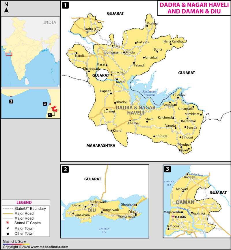
For administrative purposes, Dadra and Nagar Haveli and Daman and Diu is divided into three districts:
- Dadra and Nagar Haveli District
- Daman District
- Diu District
Tourism in Dadra and Nagar Haveli and Daman and Diu:
Dadra and Nagar Haveli and Daman and Diu is famous for its Portuguese culture, monuments, and gorgeous Gardens. It is home to beautiful gardens, lakes, beaches, and forts. This union territory has become a popular tourist destination, and some of the tourist attractions in Dadra and Nagar Haveli are the Tribal Museum, Vanganga Lake Garden, Island Garden, Mini Zoo, and Bal Udyan, and others. Whereas, Daman and Diu are popular among tourist for attractions such as Diu Fort, Bom Jesus Church, Moti Daman Fort (including Light House), Nani Daman Fort, and many more.
Dadra & Nagar Haveli and Daman & Diu UT Information | |
|---|---|
| Capital | Daman |
| Date of formation | 43856 |
| Administrator | Praful Khoda Patel |
| Tourist attractions | Tribal Museum, Vanganga Lake Garden, Island Garden, Mini Zoo, Bal Udyan, Diu Fort, Bom Jesus Church, Moti Daman Fort (including Light House), Nani Daman Fort |
| Festivals | Barash (Diwali), Diwaso, Bhawada, Khali Puja, Gangaji Fair, Nariyal Poornima, Holi, Diwali |
| Languages | Gujarati, Hindi, Marathi, English, Portuguese |
| Size | 603 sq km |
| Population (Census 2011) | 585,764 |
| Major crops | Paddy, Nagli, other hill millets, sugarcane, ragi, bajra, jowar, groundnut, pulses and beans, wheat |
| Factoids | Daman and Diu are geographically separated by the Gulf of Khambat / Gulf of Cambay |
| Dadra & Nagar Haveli and Daman & Diu was ruled by the Portuguese for more than 450 years | |
| No. of District | 3 |
Last Updated on: November 13, 2025