
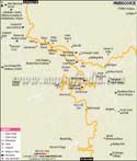
A municipal board and a cantonment town in the district with the same name, Almora is located in Uttarakhand. Founded in 1568, it is also the headquarters of Almora district. It provides a breathtaking panoramic view of the Himalayas and is known for its rich cultural heritage, handicrafts and delicious cuisines. It is also known as the cultural centre of the Kumaon region of the Uttarakhand state. Almora district has Pithoragarh to its East, Garhwal to its West, Bageshwar to its North and Nainital to its South. The city is geographically located at 29.62°N 79.67°E and has an average elevation of about 1,860 metres.
Places to See
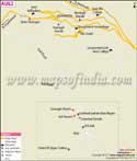
The beautiful landscape of Almora attracts a large number of tourists every year. It is also one of the business hubs of the Kumaon region. Some of the popular places of interest in the city are:
Bright End Corner:
Located at a distance of two kilometers from Almora, this place is famous for its picturesque view of the beautiful sunset and sunrise which can be seen from the Himalayan peaks. A library named Vivekananda has abundant books on literature and teachings of Vivekananda.Nanda Devi Temple:
The temple dates back to the time of Chand raja era and has many folk-art carvings. A five-day Nanda Devi fair is organised every year in the month of September.Govind Ballabh Pant Public Museum:
The museum houses many local folk art and ancient Hindu sculptures. It remains closed on Mondays and other public holidays and is open from 10:30 am to 4:30 pm.Martola:
It is an ideal picnic spot and is located in the Himalayas lush green mountains. A popular tourist spot, it is located about 10 km away from Almora.Katarmal Sun Temple:
After the Sun Temple of Konark, it is considered to be the most important temples of Sun god in India.Panchachuli Weavers Factory:
The factory employees as many as 700 women workers, who weave, market and sell woolen shawls. There are a wide range of products in the factory. Located at a distance of three kilometers, one can either take a taxi, which is available at a nominal charge, or can walk to this place.Chitai Temple or Golu Devta:
Located at a distance of 8 km from the city, the temple is dedicated to Golu Devta, who is an incarnation of the Gaur Bhairav. It is believed if a worshipper makes a wish with pure conscience; the deity of this temple definitely fulfills the wish.Deer Park, Kalimut, Kasar Devi Temple and Pandu Kholi are some of the other places of interest in the city. Ranikhet, Jalna, Kausani, Manila, Patal Bhuvaneshwar are some of the places to explore near Almora.
How to Reach?
The nearest airport to Almora is Dehradun Airport or the Indira Gandhi International Airport. Regular trains can be taken till Kathgodam or Haldwani railway station to reach Almora. Regular buses also ply to and from the city.
| Find Distance from Almora to other Indian Cities | |||
Last Updated on : May 08, 2026