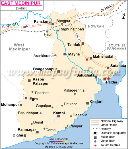
Geographical Location & Climate
East Midnapur district is located at 22 degrees 57'10" N and 21 degrees 36'35" S latitude and 88degrees 12'40"E and 86degrees 33'50 W longitude.
History and Culture
Midnapur east has a rich history. It is the land of ancient kingdoms, rich archaelogical remains, diverse tradition, varied culture, beautiful places, serene beaches and many more.
Towns and Cities
Some of the major towns and cities of East Midnapur district are Panskura, Contai, Tamluk, Egra, Haldia, Mecheda, Haria, Mahisadal, Digha, Nandigram, Mandarmoni, Ramnagar, Khejuri, Potashpur, Manglamarro, Bhagabanpur, Chandipur, Kolaghat, Nandaigajan and Paniparul
The 4 sub-divisions of the East Midnapur district are
- Tamluk
- Egra
- Contai
- Haldia
Some of the most sought after tourist attractions in East Midnapur district are Mandarmoni, Digha, Shankarpur, Haldia,
How to Reach
East Midnapur district is conveniently located with excellent connectivity to all the important places in India. The Midnapur railway station is situated on Howrah-adra and Howrah-Purulia train routes. Many local trains, express trains, frequent buses etc makes Midnapur East easily reachable. National Highway No.6 and 60 is connected to the Purba Midnapore, thereby making traveling even more easier.
| Facts of Purba Medinipur District | |
|---|---|
| State | West Bengal |
| District | Purba Medinipur |
| District HQ | Tamluk |
| Population (2011) | 5095875 |
| Growth | 15.36% |
| Sex Ratio | 938 |
| Literacy | 87.02 |
| Area (km2) | 4736 |
| Density (/km2) | 923 |
| Tehsils | Bhagawanpur I, Bhagawanpur II, Chandipur, Contai I, Contai III, Deshopran, Egra I, Egra II, Haldia, Khejuri I, Khejuri II, Kolaghat, Mahisadal, Moyna, Nanda Kumar, Nandigram I, Nandigram II, Panskura, Potashpur I, Potashpur II, Ramnagar I, Ramnagar II, Sahid Matangini, Sutahata, Tamluk |
| Lok Sabha Constituencies | Kanthi (Contai), Tamluk, Ghatal, Medinipur |
| Assembly Constituencies | Tamluk, Panskura Purba, Panskura Paschim, Moyna, Nandakumar, Mahishadal, Haldia, Nandigram, Chandipur, Patashpur, Kanthi Uttar, Bhagabanpur, Khejuri, Kanthi Dakshin, Ramnagar, Egra |
| Languages | Bengali, Hindi |
| Rivers | Rupnarayan, Haldi, Kangsabati, Chandia |
| Lat-Long | 21.943046,87.779961 |
| Travel Destinations | Rakhit bati, Temple of Devi Barghobhima, Matangani Sahid Smarak, Archeological Museum etc. |
| Government Colleges/Universities | Bajkul Milani Mahavidyalaya, College of Engineering and Management, Egra Sarada Shashi Bhusan College, Haldia Government College, Haldia Institute of Technology, Haldia Law College, Khejuri College, Maharaja Nandakumar Mahavidyalaya, Mahishadal Girls College, Mahishadal Raj College, Mugberia Gangadhar Mahavidyalaya, Panskura Banamali College, Prabhat Kumar College, Ramnagar College, Sitananda College, Tamralipta Mahavidyalaya, Vivekananda Mission Mahavidyalaya, Yogoda Satsanga Palpara Mahavidyalaya etc. |
