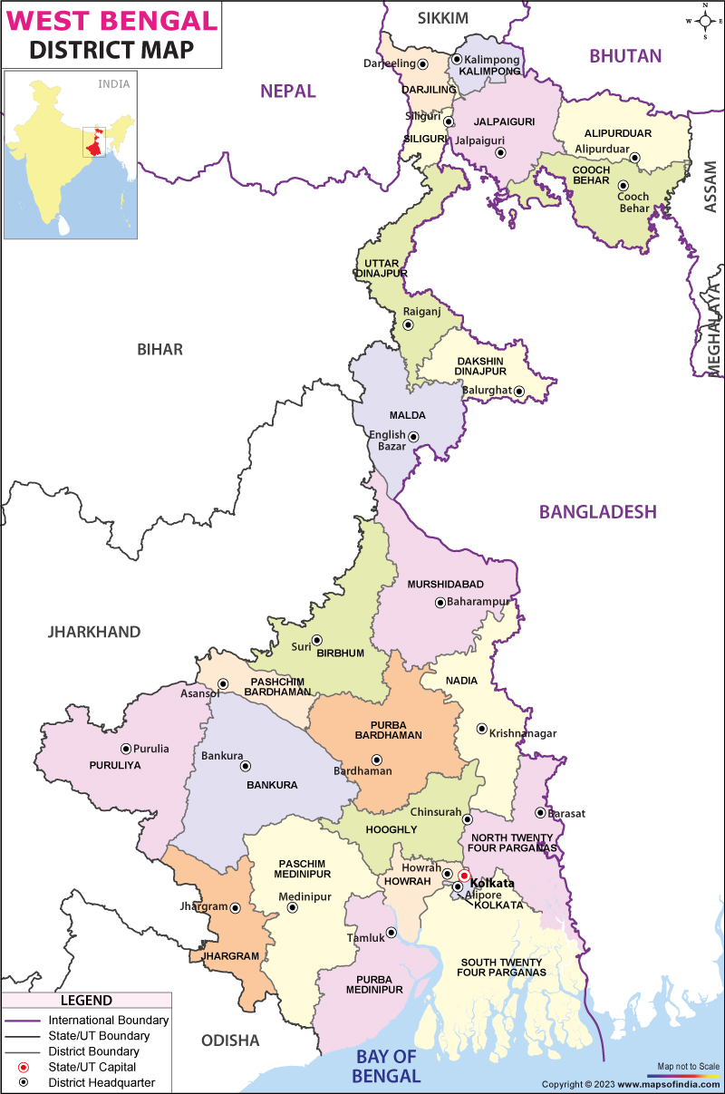
Thriving between the banks of Ganges and Brahmaputra, Bengal is a 4,000 year old civilization which sustained itself with the riches from the Gangetic Delta. Stone Age remnants and remnants of earliest cities have been found in Bengal and date back to almost 20,000 years and the Vedic period. Khana Mihirer Dhipi, Chandraketugarh (near Kolkata) and Mahasthangarh (now in Bangladesh) are some of the oldest archaeological sites dating back to 700 BCE. Bengal became a commercial hub and the gateway to the eastern parts of the Indian subcontinent having the advantage of the shortest and easiest route from the Bay of Bengal to the Himalayas (the famous Silk Route).
West Bengal is famous for its rich cultural heritage and history. The state is birthplace to great Indian leaders in literature, culture, philosophy and politics who have brought honour to India in the world arena. These include Nobel Laureate Rabindranath Tagore, Nobel laureate Amartya Sen, Raja Ram Mohan Roy (father of Social Renaissance in India), Nobel laureate Amartya Sen. Oscar recipient Satyajit Ray, Sri Ramakrishna Paramahamsa, (spiritual leader), Swami Vivekananda (Hindu reformer), Netaji Subhash Chandra Bose (Freedom fighter) Sri Aurobindo (Nationalist and philosopher), Mahasweta Devi (Novelist). Resting place of Nobel laureate Mother Teresa
The population of West Bengal is 9.13 crores(2011 census) and is spread over an area of 88,752 km sq.
Rivers flowing through West Bengal are Ajay, Barakar, Bhagirathi, Bhairab, Damodar, Ganga /Padma, Hooghly, Jalangi, Jaldhaka, Mahananda, Subarnarekha, Teesta and Torsa
Districts and Administration in West Bengal: West Bengal is divided into 23 districts and each district is governed by a District Collector or a District Magistrate, appointed by the Indian Administrative Service or the West Bengal Civil Services. Each district is further divided into sub divisions, governed by a sub divisional magistrate and then into blocks. Blocks comprise of Panchayats and town municipalities. Two districts, Jhargram (carved out of West Midnapore) and Kalimpong (carved out of Darjeeling) have recently been added. Two more districts Asansol-Durgapur (split from Burdwan) and Sundarbans (the world's largest mangrove) have been proposed to be introduced in the state.
Tourism in West Bengal: West Bengal is blessed with natural and architectural heritage. There are many places of interest in West Bengal; some of them have been listed here. It is best known for 'The Royal Bengal Tiger' in the world's largest Mangrove forest, The Sundarbans. A major tourist attraction is the Sundarbans National Park, the majestic Victoria Memorial and the the towering Howrah Bridge (Kolkatta), West Bengal also boasts of India's first underground Metro Rail. It also has the sprawling Eden Gardens, the Mecca of Cricket (in Kolkata). Terracotta Temples of Bishnupur (Bankura district), Hazarduari Palace (Murshidabad) and Darjeeling Himalayan Railways also known as 'toy train' runs between New Jalpaiguri and Darjeeling. Acharya Jagadish Chandra Bose Botanical Garden houses the world famous 250 year old 'The Great Banyan Tree' with more than 3600 aerial roots.
India's only operational cablecar - the Tramways and hand pulled Rickshaws can both be seen here. Five day continuous religious festival of Durga Puja is celebrated in West Bengal with great zeal. The famed Mustard Hilsa fish and Prawn curries are a gourmet delight in West Bengal.
Cities in West Bengal are well connected by Air, Railways and Road. Two main airports are Netaji Subhas Chandra Bose International Airport (Kolkata) and The Bagdogra Airport (near Siliguri). There are also many military airports in the state. West Bengal has a good road network with 15 National Highways (WB SH 1 to 15) connecting the cities.
List of Districts in West Bengal
| S No. | District | Headquarters | Population (Census 2011) | Sex Ratio (per 1000) | Average Literacy |
|---|---|---|---|---|---|
| 1 | Bankura | Bankura | 3596674 | 957 | 70.26% |
| 2 | Bardhaman | Bardhaman | 7717563 | 945 | 76.21% |
| 3 | Birbhum | Suri | 3502404 | 956 | 70.68% |
| 4 | Cooch Behar | Cooch Behar | 2819086 | 942 | 74.78% |
| 5 | Dakshin Dinajpur | Balurghat | 1676276 | 956 | 72.82% |
| 6 | Darjeeling | Darjeeling | 1846823 | 970 | 79.56% |
| 7 | Hooghly | Hugli-Chuchura | 5519145 | 961 | 81.80% |
| 8 | Howrah | Howrah | 4850029 | 939 | 83.31% |
| 9 | Jalpaiguri | Jalpaiguri | 3872846 | 953 | 73.25% |
| 10 | Kolkata | Kolkata | 4496694 | 908 | 86.31% |
| 11 | Malda | English Bazar | 3988845 | 944 | 61.73% |
| 12 | Murshidabad | Baharampur | 7103807 | 958 | 66.59% |
| 13 | Nadia | Krishnanagar | 5167600 | 947 | 74.97% |
| 14 | North 24 Parganas | Barasat | 10009781 | 955 | 84.06% |
| 15 | Paschim Medinipur | Midnapore | 5913457 | 966 | 78.00% |
| 16 | Purba Medinipur | Tamluk | 5095875 | 938 | 87.02% |
| 17 | Purulia | Purulia | 2930115 | 957 | 64.48% |
| 18 | South 24 Parganas | Alipore | 8161961 | 956 | 77.51% |
| 19 | Uttar Dinajpur | Raiganj | 3007134 | 939 | 59.07% |
| 20 | Alipurduar | - | - | - | - |
| 21 | Burdwan | - | - | - | - |
| 22 | Jhargram | - | - | - | - |
| 23 | Kalimpong | - | - | - | - |
| 24 | West Burdwan | - | - | - | - |
ABMOD
Last Updated on: February 19, 2026
