Chapter 10 – Atmospheric Circulation and Weather Systems Questions and Answers: NCERT Solutions for Class 11 Geography(Fundamentals of Physical Geography)

Class 11 Geography(Fundamentals of Physical Geography) NCERT book solutions for Chapter 10 - Atmospheric Circulation and Weather Systems Questions and Answers.

1. Multiple choice questions.

Question 1(i).
If the surface air pressure is 1,000 mb, the air pressure at 1 km above the surface will be:
(a) 700 mb
(b) 1,100 mb
(c) 900 mb
(d) 1,300 mb.

Answer:
(c) 900 mb

Question 1(ii).
The Inter Tropical Convergence Zone normally occurs:
(a) Near the Equator
(b) Near the Tropic of Cancer
(c) Near the Tropic of Capricorn
(d) Near the Arctic Circle.

Answer:
(a) Near the Equator

Question 1(iii).
The direction of wind around a low pressure in northern hemisphere is:
(a) Clockwise
(b) Perpendicular to isobars
(c) Anti-clock wise
(d) Parallel to isobars.

Answer:
(c) Anti clock wise

Question 1(iv).
Which one of the following is the source region for the formation of air masses?
(a) The Equatorial Forest
(b) The Himalayas
(c) The Siberian Plain
(d) The Deccan Plateau.

Answer:
(c) The Siberian plains.

2. Answer the following questions in about 30 words.
Question 2(i).
What is the unit used in measuring pressure? Why is the pressure measured at station level reduced to the sea level in preparation of weather maps?

Answer:
Millibar or Pascal is the unit for measuring pressure. Most widely used unit is kilo Pascal expressed as hpa. Horizontal distribution of pressure is studied by drawing isobars at constant levels. Isobars are lines connecting places having equal pressure. In order to eliminate the effect of altitude on pressure, it is measured at any station after being reduced to sea level for making it comparative. The pressure measured at station level is reduced to the sea level in preparation of weather maps.

Question 2(ii).
While the pressure gradient force is from north to south, i.e. from the subtropical high pressure to the equator in the northern hemisphere, why are the winds north easterlies in the tropics?

Answer:
Rotation of the earth also affects the wind movement. The force exerted by the rotation of the earth is known as the Coriolis force. Due to this effect, winds move to the right from their original direction in northern hemisphere and to the left in the southern hemisphere. The deflection is more when the wind velocity is high. The Coriolis force is directly proportional to the angle of latitude. It is maximum at the poles and is absent at the equator. The Coriolis force acts perpendicular to the pressure gradient force.
The pressure gradient force is perpendicular to an isobar. The higher the pressure gradient force, the more is the velocity of the wind and the larger is the deflection in the direction of wind. As a result of these two forces operating perpendicular to each other, in the low-pressure areas the wind blows around it. Therefore, when pressure gradient force is from south to north then winds move from south to north easterlies.

Question 2(iii).
What are the geotrophic winds?

Answer:
The velocity and direction of the
wind are the net result of the wind generating forces. The winds in the upper atmosphere, 2-3 km above the surface, are free from frictional effect of the surface and are controlled mainly by the pressure gradient and the Coriolis force. When isobars are straight and when there is no friction, the pressure gradient force is balanced by the Coriolis force and the resultant wind blows parallel to the isobar. This wind is known as the geostrophic wind.

Question 2(iv).
Explain the land and sea breezes.

Answer:
During the day the land heats up faster and becomes warmer than the sea. Therefore, over the land the air rises giving rise to a low pressure area, whereas the sea is relatively cool and the pressure over sea is relatively high.
Thus, pressure gradient from sea to land is created and the wind blows from the sea to the land which is known as sea breeze. In the night the reversal of condition takes place. The land loses heat faster and is cooler than the sea.
The pressure gradient is from the land to the sea. This breeze is known as land breeze.

3. Answer the following questions in about 150 words.
Question 3(i).
Discuss the factors affecting the speed and direction of wind.

Answer:
Air is set in motion due to the differences in atmospheric pressure. The air inmotion is called wind, which blows from high pressure to low pressure. The wind at the surface experiences friction. In addition, rotation of the earth also affects the wind movement. The force exerted by the rotation of the earth is known as the Coriolis force. Thus, the horizontal winds near the earth surface respond to the combined effect of three forces — the pressure gradient force, the frictional force and the Coriolis force. In addition, the gravitational force acts downward.
1.Pressure gradient force:Thedifferences in atmospheric pressure produce a force. The rate of change of pressure with respect to distance is the pressure gradient. The pressure gradient is strong where the isobars are close to each other and is weak where the isobars are apart.
2. Frictional force:It affects the speed of the wind. It is greatest at the surface and its influence generally extends upto an elevation of 1 – 3 km. Over the sea surface the friction is minimal.
3.Coriolis force:The rotation of the earth about its axis affects the direction of the wind. This force is called the Coriolis force. It deflects the wind to the right direction in the northern hemisphere and in nature. They oscillate with the apparent movement of the sun. In the northern hemisphere in winter they move southwards and in the summer northwards.

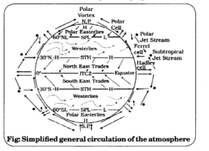
Question 3(ii).
Draw a simplified diagram to show the general circulation of the atmosphere over the globe. What are the possible reasons for the formation of subtropical high pressure over 30° N and S latitudes?

Answer:
The general circulation of the atmosphere also sets in motion the ocean water circulation which influences the earth’s climate. The general circulation of the atmosphere also affects the oceans. The large-scale winds of the atmosphere initiate large and slow moving currents of the ocean, which in turn provide input of energy and water vapour into the air.
These interactions take place rather slowly over a large part of the ocean. The air at the Inter Tropical Convergence Zone (ITCZ) rises because of convection caused by high insolation and a low pressure is created. The winds from the tropics converge at this low pressure zone. The converged air rises along with the convective cell. It reaches the top of the troposphere up to an altitude of 14 km. and moves towards the poles. This causes accumulation of air at about 30° N and S. Part of the accumulated air sinks to the ground and forms a subtropical high. Another reason . for sinking is the cooling of air when it reaches 30° N and S latitudes.

Question 3(iii).
Why does tropical cyclone originate over the seas? In which part of the tropical cyclone do torrential rains and high velocity winds blow and why?

Answer:
At the equator, the Coriolis foroe is zero and the wind blows perpendicular to the isobars. The low pressure gets filled instead of getting intensified. That is the reason why tropical cyclones are not formed near the equator.
Torrential rain occurs in the eye of the cyclone. The strong spirally circulating wind around the centre is called the eye. The diameter of the circulating system can vary between 150 and 250 km. The eye is a region of calm with subsiding air. Around the eye is the eye wall, where there is a strong spiralling ascent of air to greater height reaching the tropopause. The wind reaches maximum velocity in this region, reaching as high as 250 km per hour.
From the eye wall rain bands may radiate and trains of cumulus and cumulonimbus clouds may drift into the outer region. Due to torrential rain, wind blowing from those regions are humid. It brings precipitation in oceanic regions. Due to torrential rains, heavy rain takes place on eastern coast of India and north east coast of China.

Multiple Choice Questions

Question 1.
What does a cell in tropics called?
(a) Polar cell
(b) Hadley cell
(c) Descending winds
(d) Frost cell.

Answer:
(b) Hadley cell

Question 2.
What is tropical cyclone in Australia called?
(a) Hurricanes
(b) Typhoons
(c) Tornado
(d) Willy-willies,

Answer:
(d) Willy-willies

Question 3.
What is tropical cyclone in China and Japan called?
(a) Hurricanes
(b) Typhoons
(c) Tornado
(d) Willy-willies.

Answer:
(b) Typhoons

Question 4.
Circular flow of air in low pressure area is called:
(a) Cyclonic circulation
(b) Pascal
(c) Geomorphic winds
(d) Western storm.

Answer:
(a) Cyclonic circulation

Question 5.
The cool air, of the high plateaus and ice fields draining into the valley is called:
(a) Mountain wind
(b) Valley breeze
(c) Katabatic wind
(d) Cold front.

Answer:
(c) Katabatic wind

Question 6.
When front becomes constant, it is called:
(a) Cold front
(b) Warm front
(c) Stationary front
(d) Occluded.

Answer:
(c) Stationary front

Question 7.
From severe thunderstorms sometimes spiralling wind descends like a trunk of an elephant with great force, with very low pressure at the centre, causing massive destruction on its way. Such a phenomenon is called:
(a) Hurricanes
(b) Typhoons
(c) Tornado
(d) Willy-willies.

Answer:
(c) Tornado

Question 8.
What is the unit for measuring pressure?
(a) Barometer
(b) Millibars and Pascal
(c) Fahrenheit
(d) Isobars.

Answer:
(b) Millibars and Pascal

Question 9.
On the pole wards along 60°N and 60°S, the low-pressure belts are termed as the:
(a) Polar high
(b) Subtropicalhighs
(c) Sub polar lows
(d) Equator high.

Answer:
(c) Sub polar lows

Question 10.
How is unit kilopascal represented?
(a) hpa
(b) bpa
(c) cpa
(d) spa.

Answer:
(a) hpa

Question 11.
Which instrument is used for measuring pressure?
(a) Mercury barometer or the aneroid barometer
(b) Pascal
(c) Millibars
(d) Seismograph.

Answer:
(a) Mercury barometer or the aneroid barometer.

Very Short Answer Type Questions

Question 1.
How many types of fronts are there?

Answer:
There are four types of fronts:
Cold
Warm
Stationary
Occluded.

Question 2.
What do you mean by extra tropical cyclones?

Answer:
The systems developing in the mid and high latitude, beyond the tropics are called the middle latitude or extra tropical cyclones.

Question 3.
How do front affect weather and what is their important feature?

Answer:
The important feature of fronts is that they occur in middle latitudes and are characterised by steep gradient in temperature and pressure. They bring abrupt changes in temperature and cause the air to rise to form clouds and cause precipitation.

Question 4.
By which different names are tropical cyclones known?

Answer:
They are known as Cyclones in the Indian Ocean, Hurricanes in the Atlantic, Typhoons in the Western Pacific and South China Sea, and Willy-willies in the Western Australia.

Question 5.
What is Coriolis force?

Answer:
The rotation of the earth about its axis affects the direction of the wind. This force is called the Coriolis force after the French physicist who described it in 1844.

Question 6.
At what rate does pressure decrease with rise in height?

Answer:
In the lower atmosphere, the pressure decreases rapidly with height. The decrease amounts to about 1 mb for each 10 m increase in elevation. It does not always decrease at the same rate.

Question 7.
How do the horizontal winds near the earth surface respond to the combined effect of forces?

Answer:
The horizontal winds near the earth surface respond to the combined effect of three forces — the pressure gradient force, the frictional force and the Coriolis force.

Question 8.
What is low pressure system?

Answer:
Low- pressure system is enclosed by one or more isobars with the lowest pressure in the centre.

Question 9.
What is high pressure system?

Answer:
High-pressure system is enclosed by one or more isobars with the highest pressure in the centre.

Question 10.
What is polar cell?

Answer:
At polar latitudes the cold dense air subsides near the poles and blows towards middle latitudes as the polar easterlies. This cell is called the polar cell.

Question 11.
What is ferrel cell?

Answer:
In the middle latitudes the circulation is that of sinking cold air that comes from the poles and the rising warm air that blows from the subtropical high. At the surface these winds are called westerlies and the cell is known as the Ferrel cell.

Question 12.
What are the causes behind differences in atmospheric pressure?

Answer:
Air expands when heated and gets compressed when cooled. This results in variations in the atmospheric pressure.

Question 13.
What determines the pattern of general circulation of the atmosphere?

Answer:
The three cells set the pattern for the general circulation of the atmosphere: Hadley Cell; Ferrel Cell and Polar Cell.

Question 14.
What factors determine the pattern of planetary winds?

Answer:
The pattern of planetary winds largely depends on:
latitudinal variation of atmospheric heating;
emergence of pressure belts;
the migration of belts following apparent path of the sun;
the distribution of continents and oceans;
the rotation of earth.

Short Answer Type Questions

Question 1.
What are winds? Explain different types of winds.

Answer:
Wind is the flow of a huge amount of air, usually from a high pressure area to a low pressure area.
These are the types of wind:
Seasonal wind: The wind pattern keeps on changing in different seasons due to the shifting of regions of maximum heating, pressure and wind belts.
Local wind: Due to the differences in the heating and cooling of earth surfaces and the cycles those develop daily or annually can create several common, local or regional winds.
Mountain and valley wind: In valley regions, during the day the slopes get heated up and air moves upslope and to fill the resulting gap the air from the valley blows up the valley.

Question 2.
What is air mass? In how many categories are air masses categorized on the basis of their source regions?

Answer:
The air with distinctive characteristics in terms of temperature and humidity is called an air mass. In other words, it is defined as a large body of air having little horizontal variation in temperature and moisture.
The homogenous surfaces, over which air masses form, are called the source regions. The air masses are classified according to the source regions into five major source regions. These are:
Warm tropical and subtropical oceans: Maritime tropical (mT);
The subtropical hot deserts: Continental tropical (cT);
The relatively cold high latitude oceans: Maritime polar (mP);
The very cold snow covered continents in high latitudes: Continental polar (cP);
Permanently ice covered continents in the Arctic and Antarctica: Continental arctic (cA).

Question 3.
What is a front? How many types of front are there? Explain all of them.

Answer:
When two different air masses meet, the boundary zone between them is called a front.
The process of formation of the fronts is known as frontogenesis. There are four types of fronts:
1. Cold;
2. Warm;
3. Stationary;
4. Occluded.
Stationary front: When the front remains stationary, it is called a stationary front.
Cold front: When the cold air moves towards the warm air mass, its contact zone is called the cold front,
Warm front: If the warm air mass moves towards the cold air mass, the contact zone is a warm front.
Occluded front: If an air mass is fully lifted above the land surface, it is called the occluded front.
The fronts occur in middle latitudes and are characterised by steep gradient in temperature and pressure.
They bring abrupt changes in temperature and cause the air to rise to form clouds and cause precipitation.

Question 4.
What do you mean by Geostrophic wind? On what factors does their pattern depend?

Answer:
When isobars are straight and when there is no friction, the pressure gradient force is balanced by the Coriolis force and the resultant wind blows parallel to the isobar. This wind is known as the geostrophic wind.
The pattern of these winds largely depends on:
Latitudinal variation of atmospheric heating;
Emergence of pressure belts;
The migration of belts following apparent path of the sun;
The distribution of continents and oceans;
The rotation of earth.

Question 5.
What is a tropical cyclone? Give its two examples. What are the favourable conditions for its formation?

Answer:
Tropical cyclones are violent storms that originate over oceans in tropical areas and move over to the coastal areas bringing about large scale destruction caused by violent winds, very heavy rainfall and storm surges. This is one of the most devastating natural calamities. Cyclones in the Indian Ocean and Hurricanes in the Atlantic are its biggest examples. Tropical cyclones originate and intensify over warm tropical oceans. The conditions favourable for the formation and intensification of tropical storms are:
Large sea surface with temperature higher than 27 C;
Presence of the Coriolis force;
Small variations in the vertical wind speed;
A pre-existing weak low-pressure area or low-level-cyclonic circulation;
Upper divergence above the sea level system.

Question 6.
Explain about mountain and valley winds.

Answer:
In mountainous regions, during the day the slopes get heated up and air moves upslope and to fill the resulting gap the air from the valley blows up the valley. This wind is known as the valley breeze. During the night the slopes get cooled and the dense air descends into the valley as the mountain wind. The cool air, of the high plateaus and ice fields draining into the valley is called katabatic wind. Another type of warm wind occurs on the leeward side of the mountain ranges. The moisture in these winds, while crossing the mountain ranges condense and precipitate. When it descends down the leeward side of the slope the dry air gets warmed up by adiabatic process. This dry air may melt the snow in a short time.

Question 7.
What is atmospheric pressure? Explain about different atmospheric belts.
Or
Explain horizontal distribution of atmospheric pressure on the earth.

Answer:
The weight of a column of air contained in a unit area from the mean sea level to the top of the atmosphere is called the atmospheric pressure. The atmospheric pressure is expressed in units of millibar. At sea level the average atmospheric pressure is 1,013.2 millibar. Due to gravity the air at the surface is denser and hence has higher pressure.

Long Answer Type Questions

Question 1.
Write a detailed note on tornado.

Answer:
Meaning: A thunderstorm is a well- grown cumulonimbus cloud producing thunder and lightening. When the clouds extend to heights where sub-zero temperature prevails, hails are formed and they come down as hailstorm. If there is insufficient moisture, a thunderstorm can generate dust- storms. A thunderstorm is characterised by intense updraft of rising warm air, which causes the clouds to grow bigger and rise to greater height.
This causes precipitation. Later, downdraft brings down to earth the cool air and the rain. From severe thunderstorms sometimes spiralling wind descends like a trunk of an elephant with great force, with very low pressure at the centre, causing massive destruction on its way. Such a phenomenon is called a tornado. Features:
Tornadoes generally occur in middle latitudes.
The tornado over the sea is called water spouts.
These violent storms are the manifestation of the atmosphere’s adjustments to varying energy distribution.
The potential and heat energies are converted into kinetic energy in these storms and the restless atmosphere again returns to its stable state.

Question 2.
Write a detailed note on Coriolis Force.

Answer:
The rotation of the earth about its axis affects the direction of the wind. This force is called the Coriolis force after the French physicist who described it in 1844. It deflects the wind to the right direction in the northern hemisphere and to the left in the southern hemisphere. The deflection is more when the wind velocity is high. The Coriolis force is directly proportional to the angle of latitude. It is maximum at the poles and is absent at the equator.
The Coriolis force acts perpendicular to the pressure gradient force. The pressure gradient force is perpendicular to an isobar. The higher the pressure gradient force, the more is the velocity of the wind and the larger is the deflection in the direction of wind. As a result of these two forces operating perpendicular to each other, in the low-pressure areas the wind blows around it. At the equator, the Coriolis force is zero and the wind blows perpendicular to the isobars. The low pressure gets filled instead of getting intensified.
Differentiate between vertical variation of pressure and horizontal distribution of atmospheric pressure on earth.
Vertical variation of pressure: In the lower atmosphere the pressure decreases rapidly with height. The decrease amounts to about 1 mb for each 10 m increase in elevation. It does not always decrease at the same rate. Horizontal Distribution of Pressure: Small differences in pressure are highly significant in terms of the wind direction and purposes of comparison. The sea level pressure distribution is shown on weather maps. Low- pressure system is enclosed by one or more isobars with the lowest pressure in the centre. High- pressure system is also enclosed by one or more isobars with the highest pressure in the centre.
The vertical pressure gradient force is much larger than that of the horizontal pressure gradient. But, it is generally balanced by a nearly equal but opposite gravitational force. Hence, we do not experience strong upward winds.

Question 4.
What factors affect direction and velocity of winds?

Answer:
Air is set in motion due to the differences in atmospheric pressure. The air in motion is called wind. The wind blows from high pressure to low pressure. The wind at the surface experiences friction. Following factors affect the direction and velocity of winds.
1. Pressure gradient force: The differences in atmospheric pressure produces a force. The rate of change of pressure with respect to distance is the pressure gradient.
2. Frictional force: It affects the speed of the wind. It is greatest at the surface and its influence generally extends upto an elevation of 1 – 3 km. Over the sea surface the friction is minimal.
3.Coriolis force: The rotation of the earth about its axis affects the direction of the wind. This force is called the Coriolis force after the French physicist who described it in 1844. In addition, rotation of the earth also affects the wind movement. The force exerted by the rotation of the earth is known as the Coriolis force.
4. Pressure and wind: The velocity and direction of the wind are the net result of the wind generating forces. The winds in the upper atmosphere, 2-3 km above the surface, are free from frictional effect of the surface and are controlled mainly by the pressure gradient and the Coriolis force. When isobars are straight and when there is no friction, the pressure gradient force is balanced by the Coriolis force and the resultant wind blows parallel to the isobar. This wind is known as the geostrophic wind.