Rivers are natural flowing water bodies, generally of fresh water, that flow towards either an ocean, a lake, a sea or another river. They are a part of the hydrological cycle and the water in the rivers comes from different sources. They begin as small streams and gradually expand in size as more water gets added to them. Rivers are the source of water for many purposes such as drinking, irrigation, transportation, drainage, hydro-electricity, food and other activities.
The subcontinent of India has many rivers. The rivers in India that flow into the sea along the coast that begins from the Bay of Bengal in the east move along the Indian coast and then northward along the Arabian Sea. There are many rivers in the country that flow into the Bay of Bengal or the Arabian Sea. There are rivers in the country that flow to the neighbouring countries. The lengths of the rivers vary depending upon the area they cover. The Indus River is the longest river in India and flows through Pakistan. The Ganges is also one of the longest rivers in the country and considered the most sacred river in India due to the mythological beliefs associated with it. The Yamuna River is a tributary of Ganges and has sacred values. The Brahmaputra River is another major river of the continent of Asia as well as India.
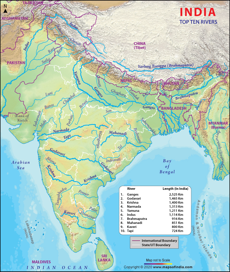
The above map will give you an insight into the top 10 rivers in India. In the above physical map of the Indian subcontinent, the rivers are marked in blue colour highlighting the places where they flow, including other countries as well. To know more about the state from where they pass, you can check the state borders marked with black dotted lines. The international boundaries are marked in purple dotted lines.
The below mentioned table shows the top 10 rivers in India on the basis of their lengths and other details:
Top 10 Rivers in India by Length
| Sl. No. | Name | Length (km) | Originates From | Ends in | Places Benefitted Countries: China, India, Bangladesh Places: Tibet, Arunachal Pradesh, Assam, Bangladesh |
|---|---|---|---|---|---|
| 1 | Ganges | 2,525 | Gangothri | Bay of Bengal | Uttar Pradesh, Uttarakhand, Bihar, West Bengal |
| 2 | Godavari | 1,465 | Nasik Hills | Bay of Bengal | South-easterly part of Andhra Pradesh |
| 3 | Krishna | 1,400 | Near Mahabaleshwar in Maharashtra | Bay of Bengal | Maharastra & Andhrapradesh |
| 4 | Narmada | 1,313 | Amarkantak hill in Madhya Pradesh | Arabian sea | Madhya Pradesh and Maharashtra |
| 5 | Yamuna | 1,211 | Garhwall in Yamunotri | Bay of Bengal | Delhi, Haryana and UP |
| 6 | Indus | 1,114 | In Tibet Kalish Range 5080 mts. | Arabian sea | India and Pakistan |
| 7 | Brahmaputra | 916 | Lake Manasarovar | Bay of Bengal | North Eastern state |
| 8 | Mahanadi | 851 | Amarkantak Plateau | Bay of Bengal | Jharkhand, Chhattisgarh, Orissa |
| 9 | Kaveri | 800 | Hills of Coorg, Karnataka | Bay of Bengal | Karnataka and Tamilnadu |
| 10 | Tapi | 724 | Bettul | Arabian sea | Madhya Pradesh and Maharashtra |
WBST170615
WBVDA
Last Updated on: December 05, 2025

