1. Choose the right answer from the four alternatives given below: Question 1(i). Which one of the following rivers was known as the ‘Sorrow of Bengal’? (a) The Gandak (b) The Son (c) The Kosi (d) The Damodar
Answer: (d) The Damodar
Question 1(ii). Which one of the following rivers has the largest river basin in India? (a) The Indus (b) The Brahmaputra (c) The Ganga (d) The Krishna
Answer: (c) The Ganga
Question 1(iii). Which one of the following rivers is not included in ‘Panchnad’? (a) The Ravi (b) The Chenab (c) The Indus (d) The Jhelum
Answer: (c) The Indus
Question 1(iv). Which one of the following rivers flows in a rift valley? (a) The Son (b) The Narmada (c) The Yamuna (d) The Luni
Answer: (b) The Narmada
Question 1(v). Which one of the following is the place of confluence of the Alaknanda and the Bhagirathi? (a) Vishnu Prayag (b) Rudra Prayag (c) Karan Prayag (d) Deva Prayag
Answer: (d) Deva Prayag
2. State the differences between the following. Question 2(i). River Basin and Watershed
Answer: River Basin Basis Watershed The catchments of large rivers are called river basins. Meaning Catchment of small rivulets and rills are often referred to as watersheds. Rivers basins are larger in area. Area Watersheds are smaller in area.
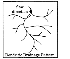
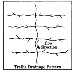
Question 2(ii). Dendritic and Trellis drainage pattern
Answer: Dendritic drainage pattern Basis Trellis drainage pattern Dendritic drainage system is a drainage pattern resembling the branches of a tree is known as “dendritic”.
The drainage pattern of Northern plain is the example of such pattern. Meaning When the primary tributaries of rivers flow parallel to each other and secondary tributaries join them at right angles, the pattern is known as ‘trellis’. This pattern is found in Himalayan mountains and the Eastern ranges (Purvanchal).
Question 2(iii). Radial and Centripetal drainage pattern
Answer: Radial drainage pattern Basis Centripetal drainage pattern When the rivers originate from a hill and flow in all directions, the drainage pattern is known as ‘radial’. The rivers originating from the Amarkantak range present a good example of it. Meaning When the rivers discharge their waters from all directions in a lake or depression, the pattern is known as ‘centripetal’. Sambhar lake of Rajasthan is the good example of it.
Question 2(iv). Delta and Estuary
Answer: Delta Basis Estuary Delta is a triangular land mass formed by depositional alluvium at the mouth of river. Shape Estuary is the sunken mouth of the river where the rivers meets the sea forming the tunnel shaped zone where saline and fresh water mix. They are formed on the tideless sea coast near the mouth of river where sediment brought by the rivers is deposited. Formation They are result of strong currents and hightides at the mouth of river where no deposition takes place. They are rich agriculture ground. Suitability They are rich fishing ground and are suitable for inland transportation. Rivers like Krishna, Kaveri, Mahanadi, Godavari form deltas. Rivers Narmada and Tapi forms estuaries.
3. Answer the following questions in about 30 words. Question 3(i). What are the socio-economic advantages of inter-linking of rivers in India?
Answer: Indian rivers are of two types: perennial rivers in which there is water through out the year and peninsular rivers in which water is there in rainy seasons only. Rivers of India bear a large amount of water every year. But its distribution is not equal from the point of view of time and place. Most of the water gets wasted in floods during rainy seasons. It also causes loss of life and property. It ruins agriculture as well. At other places, there is situation of drought. Therefore, if rivers are connected to each other through canals, then the problems of floods and drought will get solved. It will also solve the problem of drinking water and millions of rupees will be saved. It will also lead to increase in productivity. It will improve economic condition of farmers.
Question 3(ii). Write three characteristics of the Peninsular rivers.
Answer: These rivers originate in peninsular plateau and central highland. These are seasonal as it is dependent on monsoon rainfall. They reflect super imposed type of drainage pattern and rejuvenated resulting in trellis, radial and rectangular patterns. These rivers are smaller having fixed course with well-adjusted valleys. Their catchment area is relatively smaller basin. These rivers are old rivers with graded profile, and have almost reached their base levels.
4. Answer the following questions in not more than 125 words. Question 4(i). What are the important characteristic features of north Indian rivers? How are these different from Peninsular rivers?
Answer: Important characteristics of north Indian rivers are as follows: Origin: They originate in Himalayan mountain covered with glaciers. Nature of flow: These are perennial because they receive water from glacier and rainfall. Drainage pattern: These’ are antecedent and consequently lead to dendritic pattern in plains. Nature of river: It has long course, flowing through the rugged mountains experiencing headward erosion and river capturing; In plains it exhibits meandering and shifting of course. Catchment area: Its catchment areas include very large basins. Age of river: These rivers are young and youthful. These are active and deepening in the valleys. These are different from peninsular rivers because these have following features: Place of origin: Peninsular plateau and central highland. Nature of flow: Seasonal as it is dependent on monsoon rainfall. Type of drainage: Super imposed, rejuvenated resulting in trellis, radial and rectangular patterns. Nature of river: Smaller, fixed course with well-adjusted valleys. Catchment area: Relatively smaller basin. Age of the river: Old rivers with graded profile, and have almost reached their base levels.
Question 4(ii). Suppose you are travelling from Haridwar to Siliguri along the foothills of the Himalayas. Name the important rivers you will come across. Describe the characteristics of any one of them.
Answer: While travelling from Haridwar to Siliguri along the foothills of the Himalayas, we shall come across Tons, Gomti, Saryu, Ramganga, Sharda, Gandak, Old Gandak, Kamla, Bagmati, Kosi and Ganga. The Ganga is the most important river of India both from the point of view of its basin and cultural significance. It rises in the Gangotri glacier near Gaumukh which is 3,900 m high from sea level in the Uttarkashi district of Uttarakhand. It is known as the Bhagirathi in this region. At Devaprayag, the Bhagirathi meets the Alaknanda; hereafter, it is known as the Ganga. The Ganga enters the plains at Haridwar. From here, it flows first to the south, then to the south¬east and east before splitting into two distributaries, namely the Bhagirathi and the Hugli. The river has a length of 2,525 km. It is shared by Uttarakhand (110 km) and Uttar Pradesh (1,450 km), Bihar (445 km) and West Bengal (520 km). The Ganga basin covers about 8.6 lakh sq. km area in India alone. The Ganga river system is the largest in India having a number of perennial and non-perennial rivers originating in the Himalayas in the north and the Peninsula in the south, respectively. Yamuna joins the Ganga at Prayag (Allahabad). It is joined by the Chambal, the Sind, the Betwa and the Ken on its right bank which originates from the Peninsular plateau while the Hindan, the Rind, the Sengar, the Varuna, etc. join it on its left bank. Much of its water feeds the western and eastern Yamuna and the Agra canals for irrigation purposes. Multiple Choice Questions
Question 1. The pattern of flow of water in a river channel over a year is known as what? (a) Regime (b) Cumecs (c) Cusecs (d) None of these
Answer: (a) Regime
Question 2. Cumecs is measured: (a) Cubic foot per second (b) Cubic metres per second (c) In square metres (d) None of these
Answer: (b) Cubic metres per second
Question 3. When the shape of drainage system resembles branches of a tree, it is called: (a) Dendritic drainage system (b) Radial drainage system (c) Trellis (d) Centripetal Drainage System
Answer: (a) Dendritic drainage system
Question 4. The path on which the river flows along is called: (a) River course (b) River flow (c) River channel (d) Watershed
Answer: (a) River course
Question 5. Which of the following river falls into Arabian Sea? (a) Mahanadi (b) Krishna (c) Narmada (d) Kaveri
Answer: (c) Narmada
Question 6. Which of the following is the largest river of peninsular India? (a) Mahanadi (b) Krishna (c) Godavari (d) Sabarmati
Answer: (c) Godavari
Question 7. Which of the following rivers forms a delta? (a) Narmada (b) Tapti (c) Sabarmati (d) Krishna
Answer: (d) Krishna
Question 8. Which of the following river is called Dakshin Ganga? (a) Mahanadi (b) Krishna (c) Godavari (d) Sabarmati
Answer: (c) Godavari
Question 9. Name the westernmost and longest tributary of river Ganga? (a) Kosi (b) Ramganga (c) Gandak (d) Yamuna
Answer: (d) Yamuna
Question 10. By which name is river Brahmaputra known in Tibet? (a) Dihang (b) Dibang (c) Shansi (d) Sangpo
Answer: (d) Sangpo
Question 11. Which river has formed Sunderban delta? (a) Ganga (b) Krishna (c) Godavari (d) Sabarmati
Answer: (a) Ganga
Question 12. From where does river Chenab originate? (a) Baralacha Pass (b) Rohtang Pass (c) Rakstal (d) Verinag
Answer: (a) Baralacha Pass
Very Short Answer Type Questions
Question 1. On the basis of origin, form and features in how many groups can we classify rivers of India?
Answer: On the basis of origin, form and features, we can classify the rivers of India into four parts: 1. Himalayan Rivers; 2. Peninsular rivers; 3. Coastal Rivers and 4. Internal basin rivers.
Question 2. By which names is river Brahmaputra known?
Answer: In Tibet, it is called Tsangpo. It emerges as a turbulent and dynamic river after carving out a deep gorge in the Central Himalayas near Namcha Barwa (7,755 m). The river emerges from the foothills under the name of Siang or Dihang. In India, it is called Brahmaputra. In Bangladesh, it is known as the Yamuna. It finally merges with the river Padma, which falls in the Bay of Bengal.
Question 3. Name important tributaries of Brahmaputra river system.
Answer: Important tributaries of Brahmaputra river system are the Burhi Dining, Dhansari (South), Subansiri, Kameng, Manas and Sankosh.
Question 4. Define drainage system.
Answer: The flow of water through well-defined channels is known as ‘drainage’ and the network of such channels is called a ‘drainage system’. The drainage pattern of an area is the outcome of the geological time period, nature and structure of rocks, topography, slope, amount of water flowing and the periodicity of the flow.
Question 5. What are different forms of drainage system?
Answer: The different drainage patterns are “dendritic”; ‘radial’; ‘trellis’ and ‘centripetal’.
Question 6. In how many parts is Indo-Brahma drainage system dismembered?
Answer: It is opined that in due course of time Indo-Brahma river was dismembered into three main drainage systems: The Indus and its five tributaries in the western part; The Ganga and its Himalayan tributaries in the central part; The stretch of the Brahmaputra in Assam and its Himalayan tributaries in the eastern part.
Question 7. Name the longest river of Kerala. From where does it originate?
Answer: The longest river of Kerala is Bharatpuzha. It originates from Annamalai hills. It is also known as Pongnani. It covers approximately 5397 km of area.
Question 8. What type of drainage system is there in Thar Desert?
Answer: Drainage system in Thar Desert is of centripetal type.
Question 9. Name the rivers which fall in Bay of Bengal.
Answer: Important rivers falling in Bay of Bengal include Ganga, Mahanadi, Godavari, Krishna and Kaveri.
Question 10. Name the rivers which fall into Arabian Sea.
Answer: Indus and its tributaries, Narmada, Tapti, Sabarmati rivers fall into Arabian Sea.
Question 11. What is watershed?
Answer: The boundary line separating one drainage basin from the other is known as watershed.
Question 12. Name the factors on which the drainage pattern depends?
Answer: The drainage pattern of an area is the outcome of the geological time period, nature and structure of rocks, topography, slope, amount of water flowing and the periodicity of the flow.
Short Answer Type Questions
Question 1. Explain about flood prone areas of India.
Answer: The states falling within the periphery of “India Flood Prone Areas” are West Bengal, Orissa, Andhra Pradesh, Kerala, Assam, Bihar, Gujarat, Uttar Pradesh, Haryana and Punjab. The intense monsoon rains from south-west causes rivers like Brahmaputra, Ganga, Yamuna etc. to swell their banks, which in turn floods the adjacent areas. Over the past few decades, Central India has become familiar with precipitation events like torrential rains and flash floods. The major flood prone areas in India are the river banks and deltas of Ravi, Yamuna-Sahibi, Gandak, Sutlej, Ganga, Ghaggar, Kosi, Teesta, Brahmaputra, Mahanadi, Mahananda, Damodar, Godavari, Mayurakshi, Sabarmati and their tributaries. During the rainy season, much of the water is wasted in floods and flows down to the sea. Similarly, when there is a flood in one part of the country, the other area suffers from drought. The Godavari is subjected to heavy floods in its lower reaches to the south of Polavaram, where it forms a picturesque gorge.
Question 2. Explain important features of Kaveri Basin.
Answer: Important features of Kaveri Basin are as follows: The Kaveri rises in Brahmagiri hills (1,341m) of Kogadu district in Karnataka. Its length is 800 km and it drains an area of 81,155 sq. km. Since the upper catchment area receives rainfall during the southwest monsoon season (summer) and the lower part during the northeast monsoon season (winter), the river carries water throughout the year with comparatively less fluctuation than the other Peninsular rivers. About 3 per cent of the Kaveri basin falls in Kerala, 41 per cent in Karnataka and 56 per cent in Tamil Nadu. Its important tributaries are the Kabini, the Bhavani and the Amravati. The Narmada originates on the western flank of the Amarkantak plateau at a height of about 1,057 m.
Question 3. Differentiate between the features of Ganga river and Jhelum river.
Answer: The Ganga is the most important river of India both from the point of view of its basin and cultural significance. It rises in the Gangotri glacier near Gaumukh (3,900 m) in the Uttarkashi district of Uttarakhand. Here, it is known as the Bhagirathi. It cuts through the Central and the Lesser Himalayas in narrow gorges. The important left bank tributaries are the Ramganga, the Gomati, the Ghaghara, the Gandak, the Kosi and the Mahananda. The river finally discharges itself into the Bay of Bengal near the Sagar Island. The Jhelum, an important tributary of the Indus, rises from a spring at Verinag situated at the foot of the Pir Panjal in the south-eastern part of the valley of Kashmir. It flows through Srinagar and the Wular lake before entering Pakistan through a deep narrow gorge. It joins the Chenab near Jhang in Pakistan.
Question 4. The two Peninsular rivers display interesting differences in their regimes compared to the Himalayan rivers. Explain.
Answer: The two Peninsular rivers display interesting differences in their regimes compared to the Himalayan rivers. The Narmada has a very low volume of discharge from January to July but it suddenly rises in August when the maximum flow is attained. The fall in October is as spectacular as the rise in August. The flow of water in the Narmada, as recorded at Garudeshwar, shows that the maximum flow is of the order of2,300 cusecs, while the minimum flow is only 15 cusecs. The Godavari has the minimum discharge in May, and the maximum in July-August. After August, there is a sharp fall in water flow although the volume of flow in October and November is higher than that in any of the months from January to May. The mean maximum discharge of the Godavari at Polavaram is 3,200 cusecs while the mean minimum flow is only 50 cusecs.
Question 5. Flow of Ganga is not same throughout the year. Explain.
Answer: The Ganga has its minimum flow during the January-June period. The maximum flow is attained either in August or in September. After September, there is a steady fall in the flow. The river, thus, has a monsoon regime during the rainy season. There are striking differences in the river regimes in the eastern and the western parts of the Ganga Basin. The Ganga maintains a sizeable flow in the early part of summer due to snow melt before the monsoon rains begin. The mean maximum discharge of the Ganga at Farakka is about 55,000 cusecs while the mean minimum is only 1,300 cusecs.
Long Answer Type Questions
Question 1. How are rivers of India useful for India?
Answer: Rivers are useful for us because: Water: Rivers carry water and nutrients to areas all around the earth. They play a very important part in the water cycle, acting as drainage channels for surface water. Rivers drain nearly 75% of the earth’s land surface. Habitats: Rivers provide excellent habitat and food for many of the earth’s organisms. Many rare plants and trees grow by rivers. Ducks, voles, otters and beavers make their homes on the river banks. Reeds and other plants like bulrushes grow along the river banks. Other animals use the river for food and drink. Birds such as kingfishers eat small fish from the river. Delta: River deltas have many different species of wildlife. Insects, mammals and birds use the delta for their homes and for food. Transport: Rivers provide travel routes for exploration, commerce and recreation.
Question 2. Explain about Indus River System.
Answer: The Indus System It is one of the largest river basins of the world, covering an area of 11,65,000 sq. km (in India it is 321, 289 sq. km) and a total length of 2,880 km (in India 1,114 km). The Indus also known as the Sindhu, is the westernmost of the Himalayan rivers in India. It originates from a glacier near Bokhar Chu (31°15′ N latitude and 81°40′ E longitude) in the Tibetan region at an altitude of 4,164 m in the Kailash mountain range. The Indus receives a number of Himalayan tributaries such as the Shyok, the Gilgit, the Zaskar, the Hunza, the Nubra, the Shigar, the Gasting and the Dras. It finally emerges out of the hills near Attock where it receives the Kabul river on its right bank. The other important tributaries joining the right bank of the Indus are the Khurram, the Tochi, the Gomal, the Viboa and the Sangar. They all originate in the Sulaiman ranges. The river flows southward and receives ‘Panjnad’ a little above Mithankot. The Panjnad is the name given to the five rivers of Punjab, namely the Satluj, the Beas, the Ravi, the Chenab and the Jhelum. It finally discharges into the Arabian Sea, east of Karachi. The Indus flows in India only through the Leh district in Jammu and Kashmir.
Question 3. Explain about Ganga River System.
Answer: The Ganga System: 1. The Ganga is the most important river of India both from the point of view of its basin and cultural significance. It rises in the Gangotri glacier near Gaumukh (3,900 m) in the Uttarkashi district of Uttarakhand. Here, it is known as the Bhagirathi. It cuts through the Central and the Lesser Himalayas in narrow gorges. 2. At Devaprayag, the Bhagirathi meets the Alaknanda; hereafter, it is known as the Ganga. The Alaknanda has its source in the Satopanth glacier above Badrinath. The Alaknanda consists of the Dhauli and the Vishnu Ganga which meet at Joshimath or Vishnu Prayag. 3. The river has a length of 2,525 km. It is shared by Uttarakhand (110 km) and Uttar Pradesh (1,450 km), Bihar (445 km) and West Bengal (520 km). The Ganga basin covers about 8.6 lakh sq. km area in India alone. 4. The Ganga river system is the largest in India having a number of perennial and non-perennial rivers originating in the Himalayas in the north and the Peninsula in the south, respectively. The Son is its major right bank tributary. 5. The important left bank tributaries are the Ramganga, the Gomati, the Ghaghara, the Gandak, the Kosi and the Mahananda. The Yamuna, the westernmost and the longest tributary of the Ganga, has its source in the Yamunotri glacier on the western slopes of Banderpunch range (6,316 km). 6. The river finally discharges itself into the Bay of Bengal near the Sagar Island.
Question 4. What factors determine volume of water in a river?
Answer: Factors affecting the volume of water in a river: 1. An important factor affecting the volume of water in a river is the size of the drainage basin. A drainage basin in an area drained by one main river and its tributaries. If the drainage basin is large, the volume of water in the river will be more. When the drainage basin is large the surface run off flourished the river is more runoff in the amount of rainwater that flows on the ground and ultimately into the river or lake. On the other hand, if the drainage basin is small volume of water in the river will be less because there is less surface area for the rain to fall on. 2.Vegetation is also an important factor. Leaves of tress intercept rainwater and allow more water to sweep into the ground in groundwater. As a result, the amount of surface runoff reduces. Therefore, the volume of water in the river is less where vegetation is dense. Spare vegetation prevents rainwater from getting trapped in the leaves and branches, thereby allowing more water to flow through as surface runoff. So, in areas with less vegetation volume of water is more. 3. Permeability of rocks: In area with permeable or porous rocks, much of the rainwater sweeps through the pores in the rocks into the ground. In such areas, surface run off is less and water flowing into the river channel will also be less. 4. Climate: In areas with hot and wet climate such as equatorial area, volume of water rivers will be high. However, the amount of water will be less in areas with dry climate receiving less rainfall. In areas with prominent wet or dry seasons, volume of water in the river will vary according to the amount of rainfall received.
Question 5. Explain the different drainage patterns formed by rivers. Draw diagram of each drainage pattern with two examples of each.
Answer: The drainage pattern formed by rivers are: (a) Dendritic: The drainage resembling, the branches of a tree is known as ‘dendritic’ the examples of which are the rivers of northern plains like Ganga, Yamuna, etc.
(b) Radial: When the rivers originate from a hill and flow in all directions, the drainage pattern is known as ‘radial’ or the dome-shaped pattern. The river originating from the Amarkanta range and central highlands present a good example of it.
(c) Trellis: When the primary tributaries of rivers flow parallel to each and secondary tributaries join them at right angles, the pattern is known as ‘trellis’ e.g. Peninsular river such as Godavari, Krishna etc.
(d)Centripetal: When the rivers discharge their waters from all directions in a lake or in depressions, it is known as ‘centrifugal’. These rivers form cascades/rapids and waterfalls.