1. Multiple choice questions
Question 1(i). In which of the following stages of landform development, downward cutting is dominated? (a) Youth stage (b) Late mature stage (c) Early mature stage (d) Old stage.
Answer: (a) Youth stage
Question 1(ii). A deep valley characterised by steep step-like side slopes is known as (a) U-shaped valley (b) Gorg (c) Blind valley (d) Canyon.
Answer: (d) Canyon
Question 1(iii). In which one of the following regions the chemical weathering process is more dominant than the mechanical process? (a) Humid region (b) Limestone region (c) Arid region (d) Glacier region,
Answer: (b) Limestone region
Question 1(iv). Which one of the following sentences best defines the term ‘Lapies’? (a) A small to medium sized shallow depression (b) A landform whose opening is more or less circular at the top and funnel shaped towards bottom (c) A landform formed due to dripping water from surface (d) An irregular surface with sharp pinnacles, grooves and ridges.
Answer: (a) A small to medium sized shallow depression
Question 1(v). A deep, long and wide trough or basin with very steep concave high walls at its head as well as in sides is known as: (a) Cirque (b) Glacial valley (c) Lateral Moraine (d)Esker.
Answer: (a) Cirque.
2. Answer the following questions in about 30 words. Question 2(i). What do incised meanders in rocks and meanders in plains of alluvium indicate?
Answer: In streams that flow rapidly over steep gradients, normally erosion is concentrated on the bottom of the stream channel. In the case of steep gradient streams lateral erosion on the sides of the valleys is not much when compared to the streams flowing on low and gentle slopes. Because of active lateral erosion, streams flowing over gentle slopes, develop sinuous or meandering courses. It is common to find meandering courses over floodplains and delta plains where stream gradients are very gentle. But very deep and wide meanders can also be found cut in hard rocks. Meander loops develop over original gentle surfaces in the initial stages of development of streams and the same loops get entrenched into the rocks normally due to erosion or slow, continued uplift of the land over which they start. They widen and deepen over time and can be found as deep gorges and canyons in hard rock areas. They give an indication on the status of original land surfaces over which streams have developed.
Question 2(ii). Explain the evolution of valley sinks or uvalas.
Answer: Quite often the surface run-off simply goes down swallow and sink holes and flow as underground streams and reemerge at a distance downstream through a cave opening. When sink holes and dolines join together because of slumping of materials along their margins or due to roof collapse of caves, long, narrow to wide trenches called valley sinks or uvalas form.
Question 2(iii). Underground flow of water is more common than surface run-off in limestone areas. Why?
Answer: The results of the work of groundwater cannot be seen in all types of rocks. But in rocks like limestones or dolomites rich in calcium carbonate, the surface water as well as groundwater through the chemical process of solution and precipitation deposition develop varieties of landforms. These two processes of solution and precipitation are active in limestones or dolomites occurring either exclusively or interbedded with other rocks. Therefore, underground flow of water is more common than surface run off in limestone areas.
Question 2(iv). Glacial valleys show up many linear depositional forms. Give their locations and names.
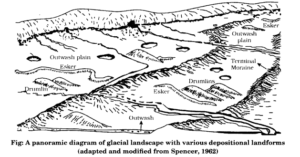
Answer: Glacial valleys show up many linear depositional forms. Their locations and names are as follows: 1. Moraines: They are long ridges of deposits of glacial till. Lateral moraines form along the sides parallel to the glacial valleys. The lateral moraines may join a terminal moraine forming a horse-shoe shaped ridge. There can be many lateral moraines on either side in a glacial valley. 2.Eskers: When glaciers melt in summer, the water flows on the surface of the ice or seeps down along the margins or even moves through holes in the ice. These waters accumulate beneath the glacier and flow like streams in a channel beneath the ice. Such streams flow over the ground with ice forming its banks. Very coarse materials like boulders and blocks along with some minor fractions of rock debris carried into this stream settle in the valley of ice beneath the glacier and after the ice melts can be found as a sinuous ridge called esker. 3. Outwash Plains: The plains at the foot of the glacial mountains or beyond the limits of continental ice sheets are covered with glacio-fluvial deposits in the form of broad flat alluvial fans which may join to form outwash plains of gravel, silt, sand and clay. 4. Drumlins: Drumlins are smooth oval shaped ridge-like features composed mainly of glacial till with some masses of gravel and sand. The long axes of drumlins are parallel to the direction of ice movement. They may measure up to 1 km in length and 30 m or so in height.
Question 2(v). How does wind perform its task in desert areas? Is it the only agent responsible for the erosional features in the deserts?
Answer: The desert floors get heated up too much and too quickly because of being dry and barren. The heated floors heat up the air directly above them and result in upward movements in the hot lighter air with turbulence, and any obstructions in its path sets up eddies, whirlwinds, updrafts and downdrafts. Winds also move along the desert floors with great speed and the obstructions in their path create turbulence. There are storm winds as well which are very destructive. Winds cause deflation, abrasion and impact. Deflation includes lifting and removal of dust and smaller particles from the surface of rocks. In the transportation process sand and silt act as effective tools to abrade the land surface. The impact is simply sheer force of momentum which occurs when sand is blown into or against a rock surface. It is similar to sand- blasting operation. The wind action creates a number of interesting erosional and depositional features in the deserts. No, wind is not the only agent responsible for the erosional features in the deserts. Wind is one of the two dominant agents in hot deserts. The other one is rain or sheet wash.
3. Answer the following questions in about 150 words. Question 3(i) Running water is by far the most dominating geomorphic agent in shaping the earth’s surface in humid as well as in arid climates. Explain.
Answer: In humid regions, which receive heavy . rainfall running water is considered the most important of the geomorphic agents in bringing about the degradation of the land surface. There are two components of running water. One is overland flow on general land surface as a sheet. Another is linear flow as streams and rivers in valleys. Most of the erosional landforms made by running water are associated with vigorous and youthful rivers flowing over steep gradients. With time, stream channels over steep gradients turn gentler due to continued erosion, and as a consequence, lose their velocity, facilitating active deposition. There may be depositional forms associated with streams flowing over steep slopes. But these phenomena will be on a small scale compared to those associated with rivers flowing over medium to gentle slopes. The gentler the river channels in gradient or slope, the greater is the deposition. When the stream beds turn gentler due to continued erosion, downward cutting becomes less dominant and lateral erosion of banks increases and as a consequence the hills and valleys are reduced to plains. In dry regions, most of the landforms are formed by the erosion and deposition of flood sheet. Although, in deserts, rain is scarce, it comes down torrentially in a short period of time. The desert rocks devoid of vegetation, exposed to mechanical and chemical weathering processes due to drastic diurnal temperature changes, decay faster and the torrential rains help in removing the weathered materials easily. That means, the weathered debris in deserts is moved by not only wind but also by rain/sheet wash.
Question 3(ii). Limestones behave differently in humid and arid climates. Why? What is the dominant and almost exclusive geomorphic process in limestone areas and what are its results?
Answer: Many depositional forms develop within the limestone caves. The chief chemical in limestone is calcium carbonate which is easily soluble in carbonated water i.e. carbon dioxide absorbed rainwater. This calcium carbonate is deposited when the water carrying it in solution evaporates or loses its carbon dioxide as it trickles over rough rock surfaces. Stalactites, Stalagmites and Pillars Stalactites hang as icicles of different diameters. Normally they are broad at their bases and taper towards the free ends showing up in a variety of forms. Stalagmites rise up from the floor of the caves. In fact, stalagmites form due to dripping water from the surface or through the thin pipe, of the stalactite, immediately below it. The results of the work of groundwater cannot be seen in all types of rocks. But in rocks like limestones or dolomites rich in calcium carbonate, the surface water as well as groundwater through the chemical process of solution and precipitation deposition develop varieties of landforms. These two processes of solution and precipitation are active in limestones or dolomites occurring either exclusively or interbedded with other rocks. Therefore, underground flow of water is more common than surface run off in limestone areas.
Question 3(iii). How do glaciers accomplish the work of reducing high mountains into low hills and plains?
Answer: Masses of ice moving as sheets over the land or as linear flows down the slopes of mountains in broad trough-like valleysare called glaciers. A glacier in its valley is slow unlike water flow. The movement could be a few centimetres to a few metres a day or even less or more. Glaciers move basically because of the force of gravity. Erosion by glaciers is tremendous because of friction caused by sheer weight of the ice. The material plucked from the land by glaciers get dragged along the floors or sides of the valleys and cause great damage through abrasion and plucking. Glaciers can cause significant damage to even unweathered rocks and can reduce high mountains into low hills and plains. As glaciers continue to move, debris gets removed, divides get lowered and eventually the slope is reduced to such an extent that, glaciers will stop moving leaving only a mass of low hills and vast outwash plains along with other depositional features.
Multiple Choice Questions
Question 1. Outwash plains are formed by: (a) Rivers (b) Glacier (c) Underground water (d) Wind.
Answer: (a) Rivers
Question 2. What are most important landforms in desert areas? (a) Chardong (b) Interbedded rocks (c) Sand dunes (d) Valleys.
Answer: (c) Sand dunes
Question 3. They are deep, long and wide troughs or basins with very steep concave to vertically dropping high walls at its head as well as sides. What are they? (a) Cirque (b) Horne (c) Esker (d) Drumlin.
Answer: (a) Cirque
Question 4. Which type of landforms are formed by rivers in youth stage? (a) Desert (b) Cirque (c) Lakes (d) V-shaped valley.
Answer: (d) V-shaped valley.
Question 5. In mature stage, loop like channel patterns develop in rivers. These are called: (a) Meanders (b) Canyon (c) Delta (d) Cirque.
Answer: (a) Meanders
Question 6. On the mouth, the river flows not on one but many sides. It is called: (a) Meanders (b) Canyon (c) Delta (d) Cirque.
Answer: (c) Delta
Question 7. Very coarse materials like boulders and blocks along with some minor fractions of rock debris carried into this stream settle in the valley of ice beneath the glacier and after the ice melts can be found as a sinuous ridge called what? (a) Meanders (b) Esker (c) Delta (d) Cirque.
Answer: (b) Esker
Question 8. Which types of landforms are formed by rivers in their mature stage? (a) Meanders, deltas and concave bank (b) V-shaped valley and waterfall (c) Canyon and sand dunes (d) U-shaped valley and gorge.
Answer: (a) Meanders, deltas and concave bank
Question 9. In which stage streams divides are broad and flat with marshes, swamp and lakes? (a) Youth stage (b) Mature stage (c) Final stage (d) Old stage.
Answer: (a) Youth stage
Question 10. Which of the following landform is not made by rivers? (a) V-shaped valley (b) Waterfall (c) Delta (d) Sand dunes.
Answer: (d) Sand Dunes
Question 11. Which of the following is created by soil erosion by the rivers? (a) V-shaped valley (b) Waterfall (c) Delta (d) Sand dunes.
Answer: (a) V-shaped valley
Question 12. Which of the following landform is made by deposition by ground water? (a) Lapies (b) Pools (c) Sinkholes (d) Stalagmites.
Answer: (d) Stalagmites
Question 13. Which of the following landform is not made by glaciers? (a) Cirque (b) Home (c) Esker (d) Stalagmites.
Answer: (d) Stalagmites
Question 14. Which of the following is responsible for making sand dunes? (a) Sea waves (b) River (c) Wind (d) Glacier.
Answer: (d) Glacier
Question 15. Which of the following is not made by deposition of waves and currents? (a) Bars (b) Dunes (c) Barriers (d) Meanders.
Answer: (d) Meanders
Question 16. Which of the following is not made by erosion, waves and currents? (a) Bars (b) Dunes (c) Barriers (d) Stacks.
Answer: (d) Stacks
Question 17. Which geomorphic agent is responsible for making of drumlins? (a) Wind (b) River (c) Ground water (d) Glaciers.
Answer: (d) Glaciers
Question 18. Which of the landform is made by rivers in old age? (a) V-shaped valley (b) Waterfall (c) Delta (d) Meanders.
Answer: (d) Meanders.
Very Short Answer Type Questions
Question 1. How do landforms transform?
Answer: Stability of sea level; tectonic stability of landmasses and climate, which influence the evolution of landforms. Any disturbance in any of these three controlling factors can upset the systematic and sequential stages in the development and evolution of landforms.
Question 2. Where are alluvial fans formed?
Answer: Alluvial fans are formed when streams flowing from higher levels break into foot slope plains of low gradient.
Question 3. Which landforms are made by rivers in their youth stage?
Answer: Rivers in youth stage form v-shaped valleys, waterfalls, canyon and meanders.
Question 4. Which landforms are made by rivers in their mature stage?
Answer: Rivers in mature stage form alluvial fans, mountaneous plains, cirques, etc.
Question 5. Which landforms are made by rivers in their old stage?
Answer: Rivers make flood plains, delta, lakes, volcanic plains in their old age.
Question 6. Name the landforms made by groundwater.
Answer: Pools, sinkholes, lapies and limestone pavements, caves, stalactites, stalagmites and pillars stalactites are formed by groundwater.
Question 7. What do you mean by meanders?
Answer: In mature stage, loop like channel patterns develop in rivers. These are called meanders.
Question 8. How does ocean barriers prevent storm and tsunami?
Answer: The coastal off-shore bars offer the first buffer or defence against storm or tsunami by absorbing most of their destructive force.
Question 9. How do inselberg get formed?
Answer: Once, pediments are formed with a steep wash slope followed by cliff or free face above it, the steep wash slope and free face retreat backwards. So, through parallel retreat of slopes, the pediments extend backwards at the expense of mountain front, and gradually, the mountain gets reduced leaving an inselberg which is a remnant of the mountain.
Question 10. What are deflation hollows?
Answer: Weathered mantle from over The rocks or bare soil, gets blown out by persistent movement of wind currents in one direction. This process may create shallow depressions called deflation hollows.
Question 11. What are blow outs?
Answer: Deflation creates numerous small pits or cavities over rock surfaces. The rock faces suffer impact and abrasion of wind- borne sand and first shallow depressions called blow outs are created.
Question 12. What are caves?
Answer: Some of the blow outs become deeper and wider. These are called caves.
Question 13. What do you mean by saltation?
Answer: Depending upon the velocity of wind, different sizes of grains are moved along the floors by rolling and carried in suspension and in this process of transportation itself, the materials get sorted. These are called saltation.
Question 14. How are pediments formed?
Answer: Pediments are formed through the erosion of mountain front through a combination of lateral erosion by streams and sheet flooding.
Short Answer Type Questions
Question 1. Explain the depositional landforms formed by groundwater.
Answer: The depositional landform formed by the groundwater are: Stalactites: Stalactites hang as icicles of different diameter. Normally they are broad at their bases and taper towards the free ends showing up in variety of forms. Stalagmites: Stalagmites rise up from the floor of the caves. In fact stalagmites form due to dripping water from the surface or through the thin pipe of stalactite, immediately below it. Stalagmite may take the shape of a column, a disc with either a smooth, rounded bulging end or a miniature crater like depression. Pillars: The stalagmite and stalactite eventually fuse to give rise to column and pillars.
Question 2. How are river terrace formed?
Answer: River terrace are basically products of erosion as they result due to vertical erosion by the stream into its own depositional flood plains. The terraces may result due to:- Receding water after a peak flow. Change in hydrological regimes due to climatic changes. Tectonic uplift of land. Sea level changes in case of rivers closer to the sea.
Question 3. Explain about drumlin.
Answer: Meaning: Drumlins are smooth oval shaped ridge-like features composed mainly of glacial till with some masses of gravel and sand. The long axes of drumlins are parallel to the direction of ice movement. Measurement and parts: They may measure up to 1 km in length and 30 m or so in height. One end of the drumlins facing the glacier called the stoss end is blunter and steeper than the other end called tail. Formation: The drumlins form due to dumping of rock debris beneath heavily loaded ice through fissures in the glacier. The stoss end gets blunted due to pushing by moving ice. Drumlins give an indication of direction of glacier movement.
Question 4. Explain the erosion done by glaciers.
Axis. Erosion by glaciers is tremendous because of friction caused by sheer weight of the ice. The material plucked from the land by glaciers get dragged along the floors or sides of the valleys and cause great damage through abrasion and plucking. Glaciers can cause significant damage to even un-weathered rocks and can reduce high mountains into low hills and plains. Stalagmites may take the shape of a column, a disc, with either a smooth, rounded bulging end or a miniature crater like depression. The stalagmite and stalactites eventually fuse to give rise to columns and pillars of different diameters. As glaciers continue to move, debris gets removed, divides get lowered and eventually the slope is reduced to such an extent that glaciers will stop moving leaving only a mass of low hills and vast outwash plains along with other depositional features. EROSIONAL LANDFORMS Cirque: Cirques are the most common of landforms in glaciated mountains. The cirques quite often are found at the heads of glacial valleys. The accumulated ice cuts these cirques while moving down the mountain tops. Horns and Serrated Ridges: Horns form through head ward erosion of the cirque walls. If three or more radiating glaciers cut headward until their cirques meet, high, sharp pointed and steep sided peaks called horns form. Glacial Valleys/Troughs: Glaciated valleys are trough-like and U-shaped with broad floors and relatively smooth, and steep sides.
Question 5. What are different depositional landforms created by oceans.
Answer: Sea waves also deposit their eroded materials. It gives birth to following landforms. Beaches and Dunes: Beaches are characteristic of shorelines that are dominated by deposition, but may occur as patches along even the rugged shores. Most of the sediment making up the beaches comes from land carried by the streams and rivers or from wave erosion. Beaches are temporary features. Bars: A ridge of sand and shingle formed in the sea in the off-shore zone (from the position of low tide waterline to seaward lying approximately parallel to the coast is called an off-shore bar. Barriers: An off-shore bar which is exposed due to further addition of sand is termed as barrier bar. Spits: The off-shore bars and barriers commonly form across the mouth of a river or at the entrance of a bay. Sometimes such barrier bars get keyed up to one end of the bay when they are called spits.
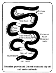
Question 6. What are the causes behind formation of river meander landform? Or Meander is not a landform but is only a type of channel pattern. Justify.
Answer: Meander is not a landform but is only a type of channel pattern because of Propensity of water flowing over very gentle gradients to work laterally on the banks. Unconsolidated nature of alluvial deposits making up the banks with many irregularities which can be used by water exerting pressure. Coriolis force acting on the fluid water deflecting, it like it deflects the wind. When the gradient of the channel becomes extremely low, water flows leisurely and starts working laterally. Normally, in meanders of large rivers, there is active deposition along the convex bank and undercutting along the concave bank. The concave bank is known as cut-off bank which shows up as a steep scarp and the convex bank presents a long, gentle profile and is known as slip-off bank. As meanders grow into deep loops, the same may get cut-off due to erosion at the inflection points and are left as Ox-bow.
Question 7. Explain the process of formation of sand dunes.
Answer: There are two types of sand dunes: 1. Sand dunes in deserts: Dry hot deserts are good places for sand dune formation. Obstacles to initiate dune formation are equally important. There can be a great variety of dune forms. Crescent shaped dunes called barchans with the points or wings directed away from wind direction i.e., downwind, form where the wind direction is constant and moderate and where the original surface over which sand is moving is almost uniform. Parabolic dunes form when sandy surfaces are partially covered with vegetation. That means parabolic dunes are reversed barchans with wind direction being the same. Longitudinal dunes form when supply of sand is poor and wind direction is constant. They appear as long ridges of considerable length but low in height. Transverse dunes are aligned perpendicular to wind direction. These dunes form when the wind direction is constant and the source of sand is an elongated feature at right angles to the wind direction. They may be very long and low in height. When sand is plenty, quite often, the regular shaped dunes coalesce and lose their individual characteristics. 2. Sand Dunes formed by waves: The sandy beach which appears so permanent may be reduced to a very narrow strip of coarse pebbles in some other season. Most of the beaches are made up of sand sized materials. Beaches called shingle beaches contain excessively small pebbles and even cobbles. Just behind the beach, the sands lifted and winnowed from over the beach surfaces will be deposited as sand dunes. Sand dunes forming long ridges parallel to the coastline are very common along low sedimentary coasts.
Question 8. What are playas or alkali regions, Explain their formation.
Answer: Plains are by far the most prominent landforms in the deserts. In basins with mountains and hills around and along, the drainage is towards the centre of the basin and due to gradual deposition of sediment from basin margins, a nearly level plain forms at the centre of the basin. In times of sufficient water, this plain is covered up by a shallow water body. Such types of shallow lakes are called as playas where water is retained only for short duration due to evaporation and quite often the playas contain good deposition of salts. The playa plain covered up by salts is called alkali flats.
Question 9. Explain the landforms created by erosion through wind.
Answer: Important erosional landforms created by wind are as follows: 1. Pediments: Landscape evolution in deserts is primarily concerned with the formation and extension of pediments. Gently inclined rocky floors close to the mountains at their foot with or without a thin cover of debris, are called pediments. Such rocky floors form through the erosion of mountain front through a combination of lateral erosion by streams and sheet flooding. Erosion starts along the steep margins of the landmass or the steep sides of the tectonically controlled steep incision features over the landmass. 2. Pediplains: Once, pediments are formed with a steep wash slope followed by cliff or free face above it, the steep wash slope and free face retreat backwards. This method of erosion is termed as parallel retreat of slopes through backwasting. So, through parallel retreat of slopes, the pediments extend backwards at the expense of mountain front, and gradually, the mountain gets reduced leaving an inselberg which is a remnant of the mountain. That’s how the high relief in desert areas is reduced to low featureless plains called pediplains. 3. Playas: Plains are by far the most prominent landforms in the deserts. In basins with mountains and hills around and along, the drainage is towards the centre of the basin and due to gradual deposition of sediment from basin margins, a nearly level plain forms at the centre of the basin. In times of sufficient water, this plain is covered up by a shallow water body. Such types of shallow lakes are called as playas where water is retained only for short duration due to evaporation and quite often the playas contain good deposition of salts. The playa plain covered up by salts is called alkali flats. 4. Deflation Hollows: Weathered mantle from over the rocks or bare soil, gets blown out by persistent movement of wind currents in one direction. This process may create shallow depressions called deflation hollows. 5. Caves: Deflation also creates numerous small pits or cavities over rock surfaces. The rock faces suffer impact and abrasion of wind-borne sand and first shallow depressions called blow outs are created, and some of the blow outs become deeper and wider fit to be called caves. 6. Mushroom, Table: Many rock-outcrops in the deserts easily susceptible to wind deflation and abrasion are worn out quickly leaving some remnants of resistant rocks polished beautifully in the shape of mushroom with a slender stalk and a broad and rounded pear shaped cap above. 7. Pedestal Rocks: Sometimes, the top surface is broad like a table top and quite often, the remnants stand out like pedestals.
Question 10. Explain the depositional landforms made by wind.
Answer: Wind is a good sorting agent. Depending upon the velocity of wind, different sizes of grains are moved along the floors by rolling or saltation and carried in suspension and in this process of transportation itself, the materials get sorted. Crescent shaped dunes called barchans with the points or wings directed away from wind direction i.e., downwind, form where the wind direction is constant and moderate and where the original surface over which sand is moving is almost uniform. Parabolic dunes form when sandy surfaces are partially covered with vegetation. That means parabolic dunes are reversed barchans with wind direction being the same. Longitudinal dunes form when supply of sand is poor and wind direction is constant. They appear as long ridges of considerable length but low in height. Transverse dunes are aligned perpendicular to wind direction. These dunes form when the wind direction is constant and the source of sand is an elongated feature at right angles to the wind direction. They may be very long and low in height. When sand is plenty, quite often, the regular shaped dunes coalesce and lose their individual characteristics.
Question 11. How does wind forms geomorphic landforms or how does wind performs its tasks in the desert areas.
Answer: Wind move along the desert floors with great speed and the obstructions in their path create turbulence. Wind causes deflations, abrasion and impact. Deflation includes lifting and removal of dust and smaller particles from the surface of rocks. In the transportation process sand and silt act as effective tools to abrade the land surface. The impact is simply sheer force of momentum which occurs when sand is blown into or against a rock surface.
Question 12. Explain the depositional landforms formed by glaciers.
Answer: The depositional landforms formed by glaciers are: Moraines: When valley glaciers retreating rapidly leave an irregular sheet of till over their valley floor. Such deposits varying greatly in thickness and in surface topography are called Moraines Esker: When glaciers melt, the water flows on the surface of the ice or seeps down along the margins or even moves through the holes in the ice. Very minor coarse materials settle in valley of ice beneath the glacier and when ice melts it can be found as sinuous ridge called Esker. Drumlins: Drumlins are smooth oral shaped ridge-like features composed mainly of glacial till with some masses of gravel and sand.
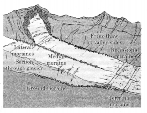
Question 13. What are Moraines? Explain different types of Moraines with diagram.
Answer: Moraines are long ridges of deposits of glacial till. Different types of moraines are: The lateral moraines: They form along the sides parallel to glacial valleys. These moraines partly or fully owe their origin to glacio- fluvial waters pushing up materials to the sides of glaciers. Ground moraines: Many valley glaciers retreating rapidly leave an irregular sheet of till over their valley floors. Such deposits varying greatly in thickness and in surface topography are called Ground moraines. Medial moraines: The moraines in the centre of the glacial valley flanked by lateral moraines is called medial moraines.