About floods in India
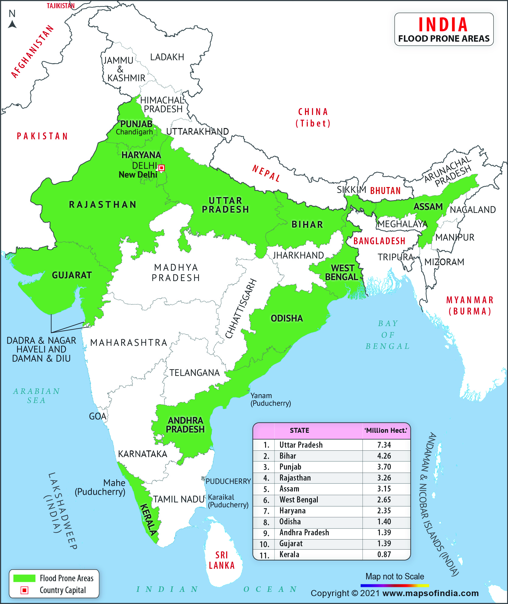
India, being a peninsular country and surrounded by the Arabian Sea, Indian Ocean and the Bay of Bengal, is quite prone to flood. As per the Geological Survey of India (GSI), the major flood prone areas of India cover almost 12.5% area of the country.
Every year, flood, the most common disaster in India causes immense loss to the country's property and lives.
India Flood Prone Areas
The states falling within the periphery of "India Flood Prone Areas" are West Bengal, Orissa, Andhra Pradesh, Kerala, Assam, Bihar, Gujrat, Uttar Pradesh, Haryana and Punjab. The intense monsoon rains from southwest causes rivers like Brahmaputra, Ganga, Yamuna etc. to swell their banks, which in turn floods the adjacent areas.
Over the past few decades, central India has become familiar with precipitation events like torrential rains and flash floods. The major flood prone areas in India are the river banks and deltas of Ravi, Yamuna-Sahibi, Gandak, Sutlej, Ganga, Ghaggar, Kosi, Teesta, Brahmaputra, Mahanadi, Mahananda, Damodar, Godavari, Mayurakshi, Sabarmati and their tributaries.
An over-view about state-wise flood prone areas can be gained by checking the following table
| state-wise Flood Prone Areas |
| State | Area liable to Floods (million Ha.) |
| Uttar Pradesh | 7.336 |
| Bihar | 4.26 |
| Punjab | 3.7 |
| Rajasthan | 3.26 |
| Assam | 3.15 |
| West Bengal | 2.65 |
| Haryana | 2.35 |
| Orissa | 1.4 |
| Andhra Pradesh | 1.39 |
| Gujarat | 1.39 |
| Kerala | 0.87 |
| Tamil Nadu | 0.45 |
| Tripura | 0.33 |
| Madhya Pradesh | 0.26 |
| Himachal Pradesh | 0.23 |
| Maharashtra | 0.23 |
| Jammu & Kashmir | 0.08 |
| Manipur | 0.08 |
| Delhi | 0.05 |
| Karnataka | 0.02 |
| Meghalaya | 0.02 |
| Pondichery | 0.01 |
| Total | 33.516 |
Highest flood prone areas in India
Though the north-Indian plains prone to flood more, the "India flood prone areas" can be broadly categorized in three divisions:
- Ganga Basin: The Ganga Basin gets flooded mostly in the northern part by its northern tributaries. The badly affected states of the Ganga basin are West Bengal, Bihar and Uttar Pradesh.
Besides the Ganga, rivers like Sarada, Rapti, Gandak and Ghagra causes flood in eastern part of Uttar Pradesh. The Yamuna is famous for flooding Haryana and Delhi. Bihar experiences massive dangerous flood every year. River Burhi,
Bagmati, Gandak, Kamla along with many small rivers contribute to that. In West Bengal, rivers like Mahananda, Bhagirathi, Damodar, Ajay etc. causes floods because of tidal effects and insufficient river channels.
- Brahmaputra and Barak Basins: The river banks of Brahmaputra and Barak gets flooded due to the Surplus water found in the Brahmaputra basin and the Barak basin. These rivers along with their tributaries flood the northeastern states like West Bengal, Assam and Sikkim. Jaldakha, Teesta and Torsa in northern West Bengal and rivers in Manipur often overflow their banks.
- Central India and Deccan Rivers Basin: In Orissa, spilling over of river banks by Mahanadi, Baitarni and Brahmani causes havoc. The deltaic area formed by these three rivers is thickly populated. Even some small rivers of Kerala and mud stream from the nearby hills add on to the destruction. Southern and central India observes floods caused by Narmada, Godavari, Tapi, Krishna and Mahanadi due to heavy rainfall. Cyclonic storms in the deltaic regions of Godavari, Mahanadi and Krishna even floods the coastal regions of Andhra Pradesh, Orissa and Tamil Nadu occasionally.
| Average Annual Flood Damage (1953 - 1999) |
| State | Area liable to Floods (million Ha.) |
| Total Damage | Rs.13,400 million |
| Area Affected | 8.11 million hectare |
| Crop Area Affected | 3.57 million hectare |
| Human Lives Lost | 1579 Nos. |
| Cattle Lost | 95,000 Nos. |
Last Updated on: December 05, 2025

