| Click on the Map for Bigger Map |
|
India Road Maps |
 |
 |
 |
 |
 |
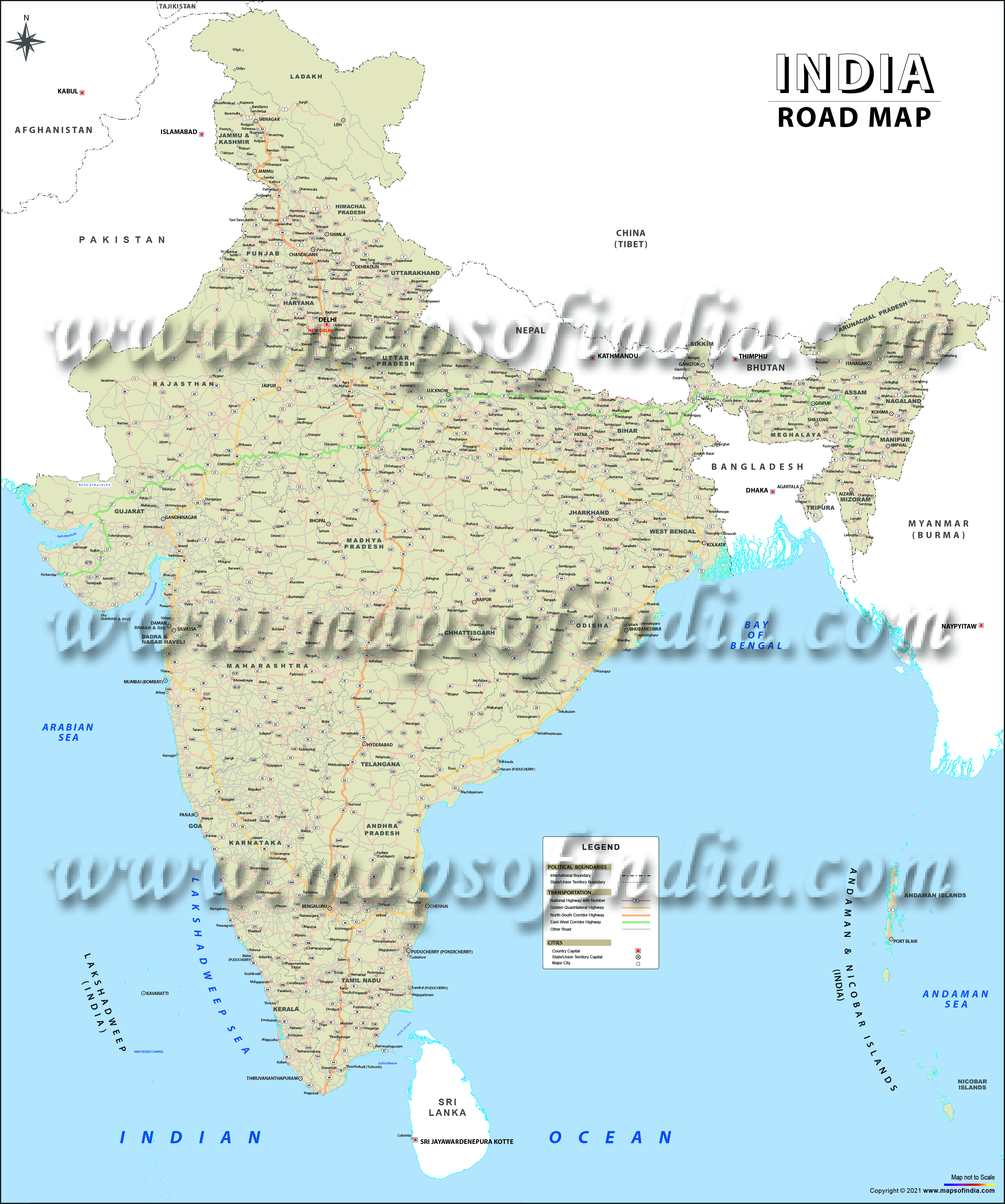
India road maps help you understand the country's extensive road network. India has one of the world's largest road networks, spanning over 6.6 million kilometres, making it the second-largest road network globally. For every square kilometre of land, India has an extensive road network that continues to expand through investments in National Highways, State Highways, and rural roads. India has one of the world's most extensive road networks, supporting connectivity across urban, rural, and remote regions. Today, a significant proportion of India's road network consists of paved roads, with continuous upgrades being carried out under various central and state government infrastructure programmes. India now has over 5,000 km of operational expressways, with several thousand kilometres under construction or planned as part of the Bharatmala Pariyojana and other infrastructure projects. India has a national highway network of over 1,46,000 kilometres.
Overview
Previously, India did not allot funds for constructing or upkeep of its roadways network. However, the scenario has evolved over the past 15 years. The Government of India, in collaboration with a number of private players, is taking groundbreaking endeavours for overhauling the road transportation system of the nation.
The Government of India continues to invest significantly in expanding and modernising the country's road infrastructure through various flagship programmes.
Till date, some of the important plans that have been put into operation include names like the Yamuna Expressway, National Highways Development Project, and the Mumbai-Pune Expressway.
India has developed an extensive network of four-lane, six-lane, and access-controlled highways connecting major commercial, industrial, and cultural centres across the country. India continues to attract substantial domestic and foreign investment for road and transport infrastructure through public-private partnerships (PPP) and government-led initiatives.
Statistics related to the Indian Roadways Network
As a whole, roads in the country are mostly tarmac roads with bitumen as one of the major construction ingredients. Nevertheless, some of the National Highways feature concrete roads as well. In cities like Kanpur, concrete roads constructed by the British government are still operational. Earlier than the 1990s, concrete roads did not gain so much popularity due to insufficient availability of cement at that time. Nonetheless, with the increased availability of cement in India and the excellent features of concrete roads, they are once more garnering popularity. This type of roads has higher durability and needs less upkeep than the bitumen-based thoroughfares.
| Indian Road Network | |
|---|---|
| Type | Length (km) |
| State Highways | ≈1,79,535 |
| Expressways/National Highways | ≈1,46,204 |
| Rural and other roads | ≈ 4.8 million |
| Important district roads | ≈ 500,000 |
| Total (approximate figure) | Over 6.6 million km |
Expressways in India
In 2009, access-regulated expressways in India comprised around 120 miles or 200 km of the National Highway System of the country. By 2011, these added to more than 5,000 km. These roads allow high speeding vehicles and can be categorised into four-lane and six-lane expressways. The expressway network continues to expand with several new corridors becoming operational every year. Several greenfield and brownfield expressway projects are under construction under the Bharatmala Pariyojana and state infrastructure programmes.
The expressways in India are access regulated and come with a separator in the middle and feature four or six traffic lanes together with a raised border on both sides. These expressways normally don't permit three-wheelers, two-wheelers, or tractor vehicles to travel on them. A speed limit of 75 mph or 120 km/hr has to be kept on these thoroughfares because of different joining traffic lanes and the absence of speed breakers just to guarantee uninterrupted journey. A majority of the present expressways in the country are toll roads.
| List of expressways in India | |
|---|---|
| Given below is a list of expressways in India: | |
Expressway Name | |
| Name | State |
| Mumbai-Pune Expressway | Maharashtra |
| Ahmedabad Vadodara Expressway | Gujarat |
| Prayagraj Bypass | Uttar Pradesh |
| Jaipur-Kishangarh Expressway | Rajasthan |
| Chennai Bypass | Tamil Nadu |
| Durgapur Expressway | West Bengal |
| Noida-Greater Noida Expressway | Delhi/Uttar Pradesh |
| Delhi-Gurgaon Expressway | Delhi/Haryana |
| Hyderabad Elevated Expressways | Telangana |
| Delhi Noida Direct Flyway | Delhi/Uttar Pradesh |
| Kona Expressway | West Bengal |
| Hosur Road Elevated Expressway | Karnataka |
| Outer Ring Road (Hyderabad) | Telangana |
| Ambala Chandigarh Expressway | Haryana |
| Raipur-Bhilai-Durg Expressway | Chhattisgarh |
| Delhi–Mumbai Expressway | Delhi/NCR, Haryana, Rajasthan, Madhya Pradesh, Gujarat, Maharashtra |
| Dwarka Expressway | Delhi, Haryana |
| Purvanchal Expressway | Uttar Pradesh |
| Bundelkhand Expressway | Uttar Pradesh |
| Samruddhi Mahamarg | Maharashtra |
| Delhi–Meerut Expressway | Delhi, Uttar Pradesh |
| Bengaluru–Mysuru Expressway | Karnataka |
| List of Expressways under construction | |
|---|---|
| Given below is a list of expressways that are under construction in India: | |
Expressway Name | |
| Name | State |
| Eastern Freeway Mumbai | Maharashtra |
| Western Freeway Mumbai | Maharashtra |
| Kundli Manesar Palwal Expressway(KMP) | Haryana |
| Mumbai Nashik Expressway | Maharashtra |
| Pathankot Ajmer Expressway | Punjab/Rajasthan |
| Delhi Eastern Peripheral Expressway | Uttar Pradesh/Haryana |
| Yamuna Expressway | Delhi/Uttar Pradesh |
| Ganga Expressway | Uttar Pradesh |
| Upper Ganga Canal Expressway | Uttar Pradesh |
| Bamroli Althan Expressway | Gujarat |
| Hungund Hospet Expressway | Karnataka |
| Chennai Port Maduravoyal Expressway | Tamil Nadu |
| Suratkal-B.C Road Expressway | Karnataka |
| Hyderabad ORR | Andhra Pradesh |
| Raipur-Bilaspur Expressway | Chhattisgarh |
National Highways in India
The National Highways are the principal highways moving across the length and breadth of the nation, joining important harbours, big commercial and tourism hubs, state capitals, and so on. National Highways in the country are represented as NH, and then the highway number comes after it. These highways are again categorised on the basis of the girth of motorway of the road. Usually, for a single lane, the breadth of the lane is 3.75 metres. At the same time, for National Highways with many lanes, the breadth of every lane is 3.5 metres.
Till the month of September 2011, the country had finished and put into operation newly constructed highways as given below:
- East-West and North-South Corridor highway (5,831 km) 4-lane
- Golden Quadrilateral highway (5,829 km) 4-lane
- Inter-capital highways (1,342 km) 4-lane
- Port connectivity highways (330 km) 4-lane
- Bypass and other national highways (945 km) 4-lane.
By the month of February 2008, out of the overall span of 7,000 km of finished highways, 14% of them featured four or higher number of lanes and approximately 59% featured double lanes or two lanes. At the same time, the remaining 27% of the National Highway transportation system featured one lane or a middle lane. Furthermore, by 2008, the country had offered various contracts in the form of a build-operate-transfer pattern and public-private partnership to grow the countrywide road transportation network.
The National Highways Authority of India (NHAI) is the principal authority which has the responsibility for the expansion, upkeep and handling of National Highways assigned to it. Till 2008, the National Highways Authority of India commenced the expansion operations under the National Highways Development Project (NHDP) in stages. Other than the completion of NHDP, the agency also has the responsibility for executing other plans on National Highways, mostly road connectivity to important harbours in India.
The national highway network in India is supervised by the Ministry of State for Surface Transport. The public works departments of various states look after the state roads and state highways. The state and union governments have common responsibilities for constructing thoroughfares and sustaining the roadways in the country.
State Highways in India
The state highways are used to join with the National Highways, major towns, district headquarters, tourism hubs and small harbours and facilitate the movement of vehicles in important places of the state. These roads are essentially arterial roads, and they facilitate accessibility to major metropolitan areas and townships in the state in association with the State Highways of the bordering states and National Highways. The overall span of the state highways is approximately 1,79,535 km.
Other than the state highways, expressways, and national highways, there are some district roads and rural roads that form a significant part of the transportation network of the country.
Last Updated on: July 08, 2026
Maps and Information on Road Network of India
State Road Networks
