Bangalore is the capital of Karnataka and the IT hub of the country. Chennai is the capital of Tamil Nadu and an important industrial and port city. Both the cities are populous metropolises of the country.
At present the National Highway no 4, along with National Highway 7 and National Highway 46 are the roads connecting these two cities. The NH 7 starting from Varanasi in UP connects north India to Chennai. The NH 4 passes through Maharashtra and connects Mumbai to Bangalore and then to Chennai. NH 46 runs within the state of Tamil Nadu and connects Krishnagiri to Ranipet.
All the roads connecting Bengaluru and Chennai pass through a number of towns and some go through long detours through the Eastern Ghats. The four lane Krishnagiri road, part of the NH 7 and NH 44, and also of the Golden Quadrilateral connecting all the metropolitan towns of the country-Delhi, Mumbai, Kolkata and Chennai- is the most widely used road and 343 kilometer long. Alternatively, a second route which is the Old Madras road and part of NH4 goes through Chittoor. Although it is shorter than the NH7 stretch, is a two lane road and is congested. It also passes through three states. There is a third road, 345 kilometers long, part of the NH 46 , that connects the cities, but as it goes through the Eastern Ghats, it is has many sharp bends.
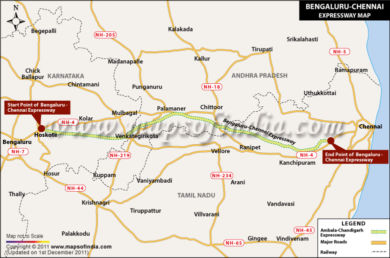
The six-lane expressway with a total length of 250 kilometers would pass through Karnataka, Andhra Pradesh and Tamil Nadu. It would begin at Hoskote in north Bengaluru and run through Malur in Karnataka, Palmaner and V Kota in Andhra Pradesh. In Tamil Nadu it would go through Gudiyatam and Arakkonam, culminating at Sriperumbudur, 40 kilometers from Chennai.
As this would be the shortest route between the two cities of Bangalore and Chennai, the expressway with a design speed of 120 kilometer per hour would reduce the travelling time between the cities to just two hours.
Last Updated on : January 20, 2026
