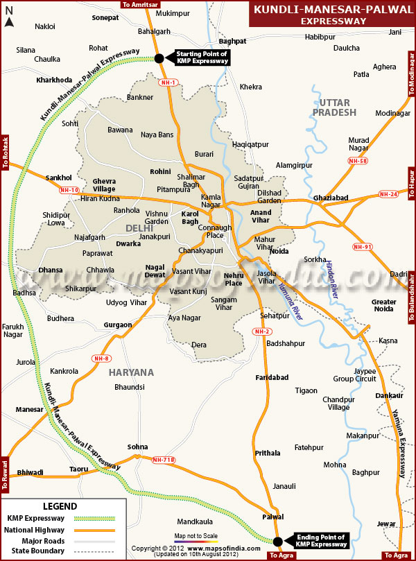
Kundli-Manesar-Palwal Expressway is popularly called Western Peripheral Expressway. This expressway in Haryana will run between Kundli and Palwal.
The expressway measuring 135.6 km in length, crosses four National Highways namely NH1 near Kundli, NH2 near palwal, NH8 near Manesar, NH 10 near Bahadurgarh and State Highway 13 (Gurgaon to Alwar). A flyover is being constructed at each of the National highways where the expressway crosses it. Besides, 143 underpasses and crossing passages are being constructed for vehicles and pedestrians at the places where the expressway connects to villages and towns. Several major and minor bridges are proposed to be constructed at 292 locations across the expressway.
The work on the expressway will be completed in three sections. Each section will cover a stretch of 45 kms. The construction work for the expressway was planned to be completed by July 2009 initially but due to extended delays, the project is still lingering in between and travelers are waiting for a time when the expressway will be ready and their traffic problems will be eased a little. The expressway however, has only seen a growth of 64% and is not expected to be open for general public even for the next six months.
Last Updated on: January 14, 2026
KMP Expressway |
|
||||||||
 |
||||||||
|
|
|
*Kundli Manesar Palwal Expressway (KMP) Expressway Map showing all the major localities which will link this expressway and the connectivity of Delhi and NCR. |
Disclaimer |
- Delhi Map
- Delhi Metro Map
- Central secretariat Metro Map
- Multilevel Parking Locations in Delhi
- Anand Vihar ISBT Metro Map
- Delhi NCR Map
- Delhi Tourist Map
- 3 Star Hotels in New Delhi
- Chanakyapuri Map
- Amusement Parks in Delhi
- New Delhi Cinema Halls
- Museums in New Delhi
- New Delhi Post Offices
- Stadiums in New Delhi
- Distance Chart of Delhi
- Latitude & Longitude of Delhi
- South Campus Map
- Mukundpur to Shiv Vihar Metro Map
- Jahangirpuri to Badli Metro Map
- Delhi Large City Map
- Ramlila Maidan Detailed
Map - Delhi NCR Metro Map
- Dwarka Metro Map
- Delhi Metro Stations Map
- Delhi NCR Region Map
- 5 Star Hotel in New Delhi
- Connaught Place Map
- Map of India Gate
- Art Galleries in New Delhi
- New Delhi Hospitals
- Parks and Gardens in Delhi
- New Delhi Railway Station
- Delhi PVR Map
- Delhi Local Area Map
- Profile of Delhi
- Ramlila Maidan Location
- Dwarka to Najafgarh Metro Map
- Central Secretariat to Kashmere Gate Metro Map
- Delhi Metro Phase 3 Map
- Location of Jama Masjid
- KMP Expressway Map
- Delhi Metro Fare Calculator
- Delhi Interactive Map
- Delhi Location Map
- Delhi Road Map
- 4 Star Hotel in New Delhi
- Delhi Forest Map
- New Delhi Airport
- Bus Terminals in Delhi Map
- Libraries in New Delhi
- Important Places in Delhi
- Shopping Complex in Delhi
- Flights to Delhi
- Education in Delhi
- Driving Directions Maps
- North Campus Map
- Mundka to Bahadurgarh Metro Map
- Janakpuri to Kalindi Kunj Metro Map