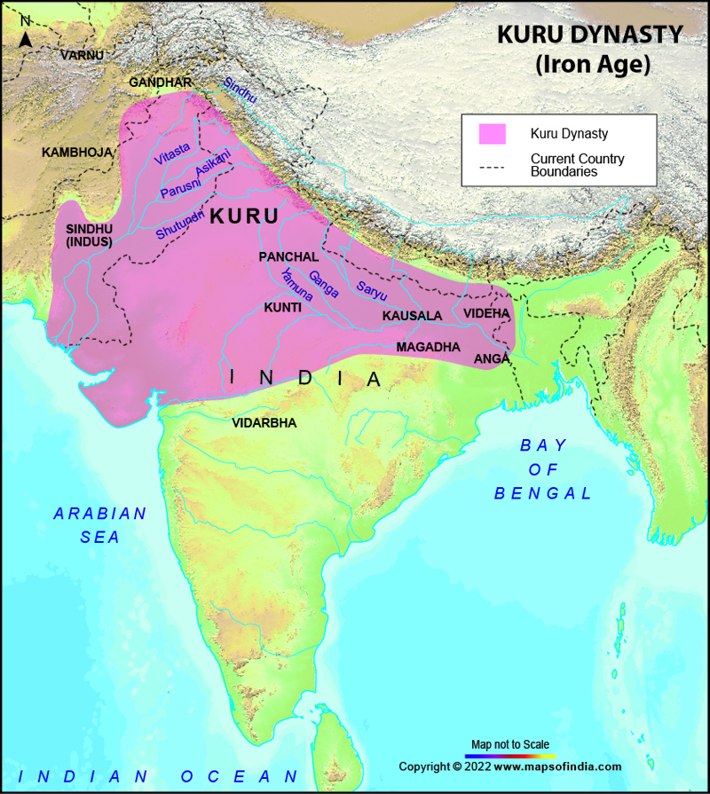
The Kuru Dynasty evolved in the early Vedic period and in the later Vedic period it developed into a republican Mahajanapada state. In the Iron Age Vedic India, an Indo-Aryan Clan was known as Kuru. The areas around modern Haryana, Delhi and some other western parts of the Northern India (the region of Doab, till Prayag/Kaushambi in Uttar Pradesh) formed the main location of this clan.
The Kuru clan is segregated into two parts on the basis of the ancient texts, according to which, between the Rigvedic River Saraswati and river Ganges lays the territory of the Kurus. These two parts are Kuru-Jangala and Kuru Proper.
Initially the Kurus, the Indo-aryans ruled the Ganga-Jamuna Doab and the earlier Eastern Punjab region. Although in the early Vedic period, the focus of this civilization turned to Punjab. The Doab region was covered by thick dense forests then and wasn't completely inhabited. In the later Vedic period, the focus completely shifted to Punjab for several reasons.
The reasons could be many, one being the drying up of the Saraswati River since the civilization had flourished around its banks. Also the other reason that comes to notice is the increase in the population during the later Vedic period. This population increase was certainly due to the expanded economy which was based on agriculture.
The Kuru-Land is originally known as Aryavarta. This name to the Kuru-land is given by the Indo-Aryans. Although the Aryavarta spread over many other regions as well, the Doab remained the centre not only for the Vedic civilization but also for the Hindu culture, customs and religion. It is said by Aitareya Brahmana that another clan, known as the Northern Kurus of the Himalayas also existed.
The result of the merging and alliance of two famous tribes, Bharata and Puru in the early Vedic time was the Kuru tribe. It was in 1200 to 800 BCE that the first political center of the Vedic period was formed, with its capital being Hastinapur.
The Kuru capital was shifted to Kaushambi (lower Doab) after the floods and family upheavals of the Kuru family destroyed Hastinapur. The capital was shifted towards the end of the early Vedic period.
A titular chieftain (king consul) namely Korayvya ruled over the Kuru country at the time of the great Gautama Buddha. Though the same position was not maintained by the Kurus of the Buddhist period in contrast to their position in the Vedic period, they enjoyed great reputation which they had for their deep wisdom and sound health throughout.
Matrimonial relations and treaties were developed between the Kurus and the Yadavas, the Bhojas and the Panchalas. Also it is said that king Dhananjaya was introduced as a prince, who belonged to the race of Yudhishtra (of Mahabharata). The Kurus, earlier were successful monarchial people but they are known to have changed their government type, during the sixth to fifth century BCE, to republican form of government. Kautiliya's Arthashastra, in the fourth century BCE, also presents clear evidence of the Kurus following the constitution of Rajashabdopajivin (king consul).
Last Updated on: November 13, 2025
Kuru Dynasty Map |
| ||||||||
 | ||||||||
|
|
*Map showing Kuru Dynasty with Boundaries and Cities where they ruled.
Disclaimer: All efforts have been made to make this image accurate. However Mapping Digiworld Pvt Ltd and its directors do not own any responsibility for the correctness or authencity of the same.
Disclaimer: All efforts have been made to make this image accurate. However Mapping Digiworld Pvt Ltd and its directors do not own any responsibility for the correctness or authencity of the same.