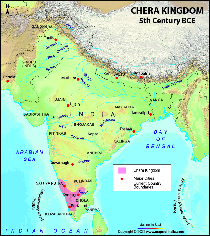
One of the most important dynasties, Chera Dynasty is the most prominent Tamil dynasty which ever flourished in the country. The Cheras, the Pandyas and the Cholas together constituted as the main warring Iron Age Tamil kingdoms. The Cheras established their rule in the 3rd century BC and ruled till the twelfth century AD.
The inscriptions of Ashoka, the great Mauryan Emperor also talks about the megalithic phase of the Cheras along with Pandyas, Satyaputras and Cholas. In the Sangam age, the Chera Dynasty was popularly known as Malaiyar, Villavar and vanavar. This dynasty was as important as the Cholas and the Pandyas in the Christian age.
The Chera Empire was ruled by two important lines of rulers. The first line begins from Uthiyan Cheralathan whereas; the second line begins from Irumporai. It is believed that the father of the Chola King Karikala, Ilamcetcenni was killed by the Cheras, but even the then Chera king died later in the action. Also, for a shot period the Cheras developed friendly relations with the Cholas, conducting matrimonial alliances but soon they joined hands with the Pandyas against Cholas. However the Cheras and the Pandyas together were defeated by the Cholas. The severely injured Chera ruler, Uthiyan Cheralathan committed suicide.
The Chera Empire began to decline in the third century AD when the Kalabhra Interregnum interrupted the reign of Cheras. This dynasty came to be known as the Kulashekharas of Mahodayapuram after the reign of the Chera king Kulashekhar Varman. The first Chera dynasty ruled till the fifth century AD whereas the second Chera dynasty initiated its rule from the ninth century AD. Not much is said and known about the gap between the fifth and the ninth century AD.
The present day's Kerala, Dharmapuri and salem are said to be the parts of the former Chera rule. After the wedding of the first Chera king into the Chola royal family even the southern Nagapattanam and Thiruvarur were added to their reign. Also successful trade relations were developed with Rome under the Chera rule. Muziris was the famous sea port of ancient India. Spices, timber, pearls, ivory and gems were exported to the kingdoms of Middle East and southern Europe from this Indian port. The coasts of Karur, Malabar and Coimbtore conducted heavy foreign trade as well. The capital of the Cheras was first Vanchi Muthur but later it was shifted to Karuvur in the second century AD. All religions were given equal importance and respect in the Chera rule and Jewish, Christian and Muslim immigrants were found in their reign.
The Kulashekharas, belonging to the second Chera dynasty initiated their rule form the outskirts of Muziris, which is located on the banks of river Periyar. They had put in great efforts to conquer the old Chera statues but couldn't. They were constantly at fight and conflict with their neighbours. It was finally in twelfth century AD that due to the frequent invasions by the Cholas their dynasty collapsed and faced their downfall.
Last Updated on: November 13, 2025
Chera Dynasty Map |
| ||||||||
 | ||||||||
|
|
*Map showing major cities and current country boundaries during the Chera period.The kingdom of Chera reigned over south India.
Disclaimer: All efforts have been made to make this image accurate. However Mapping Digiworld Pvt Ltd and its directors do not own any responsibility for the correctness or authencity of the same.
Disclaimer: All efforts have been made to make this image accurate. However Mapping Digiworld Pvt Ltd and its directors do not own any responsibility for the correctness or authencity of the same.