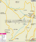
Situated on the banks of River Tawi, Jammu is the largest city of Jammu Division. It also serves as the winter capital of Jammu & Kashmir state and is full of beauty. Jammu is sub-divided into two separate cities; the old city is situated on a hilltop while the new town is located several kilometers away across the river. To the north, east and northeast, Jammu is surrounded by Shivalik range and in the north-west the Trikuta Range surrounds it. Located near the Himalayas, the city generally experiences cold weather though summers are relatively warm. The Jammu district has an area of 2,336 sq km and had a population of 15.27 lakh as per census 2011.
As per ancient beliefs, the name 'Jammu' is believed to have been derived from the name of the ruler, Raja Jambu Lochan, who founded it during the 14th century. It was the winter capital of the erstwhile princely state Jammu and Kashmir. Evidences have also proved that it has also been a part of the Harappan civilisation. Jammu was also under the control of the Sikhs, the Mughals and the British. The city is the economic centre for the Jammu administrative unit and houses many small industries.
There are many educational institutes in the city. Jammu is home to many schools, government colleges, as well as engineering and medical colleges. The city is also famous for its food, especially the local cuisine- rajma with rice. The people of Jammu speak many languages like Hindi, Kashmiri, Urdu, Punjabi and Dogri.
Tourism is the largest industry in Jammu. There are many historical places and pilgrims sites that attract a large number of tourists. It is a focal point for one of the main pilgrim sites for the Hindus, Vaishno Devi. Other pilgrim places are Raghunath temple, which is about 130 year old. Bahu Fort is one of the oldest forts in the region and houses a temple. It is at a distance of about 5 km from the city. The temple is dedicated to Goddess Kali who is popularly known as Bave wali Mata. Ranbireshwar temple is dedicated to Lord Shiva and houses 12 'shiva lingas' made from crystal. Bagh-e-Bahu, a Mughal-era garden is located at the banks of river Tawi. Peer Kho Cave Temple is another temple dedicated to Lord Shiva and it is believed that Jamvant (the bear God) had meditated in this cave. Raghunath Temple, Gauri Shankar Temple and Mahmaya Temple are some of the other places of interest in the city.
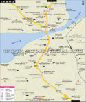
The city is very well connected via road, rail and air. The Jammu airport is at a distance of about 8 km from the city and connects it to all the major cities and states of the country. The Jammu Tawi railway station connects it to all the major cities of India. Jammu has a large network of roads which connects it to almost all the major cities of North India like Delhi, Chandigarh, Amritsar and Manali. National Highway 1A connects it to Kashmir Valley while NH 18 connects it to Pooch town. J&K State Road Transport Corporation (JKSRTC) plies buses in the city and also offers intercity facilities.
WBST310315
Last Updated on : May 08, 2026