Driving in Punjab
Roads in Punjab are some of the best laid ones in the country. Driving down the national highways or the state highways, with picturesque villages, acres of green farms and number of Dhabhas- famed culinary eateries- en route to any corner of the state makes for a scintillating experience.
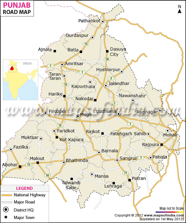
With the capital Chandigarh and the main cities Amritsar, Jalandhar, Bhatinda, Firozpur and Pathankot on the national highways, and remote towns of Sangrur, Taran Taran, Shri Hargobind and Sirhind connected by newly laid roads, every part of the state is accessible by road. However, the speed limit for light motors on national highways in Punjab is 80Kmp and in state highways 70kmp; Within Municipal areas it is 50kmp.
National Highways
With total length of 1557 km., eleven national highways pass through Punjab. NH 1, historically part of the medieval Grand Trunk road, links Delhi, passing from Jalandhar, Ludhiana, Amritsar and Patiala to Attari on the Wagah border near Pakistan. Another national highway NH 10 connects Delhi to Fazilka near Pak border. NH1A connects Uri in J&K, passing through Jammu, to Jalandhar in Punjab. The 350km long NH15 connects Kandla in Gujrat and Rajasthan border to Pathankot, and NH20 connects Pathankot with Mandi in Himachal.
NH21 connects Chandigarh with Manali in Himachal while NH22 runs from Ambala to Himachal to Khab on the Chinese border. The 40 km stretch of the NH22 which passes through Punjab is the new, state of the art toll-roads with four lanes, the Ambala Chandigarh Expressway.
NH64 connecting Chandigarh to Dabwali , and NH95 connecting Chandigarh to Firozepur , are entirely within the state . NH70 links Jalandhar to Mandi in Himachal and NH71 connects Jalandhar passing through Sangrur to Rewari in Haryana. NH 72 links Ambala on the border of Haryana and Punjab, passing through Dehradun , to Haridwar in Uttranchal.
State highways
With the World Bank aided Punjab State Road Ways responsible for upgrading and maintaining the roads in the state, all the remote corners of the state have been connected. Punjab has added 465 km of roads till recently and it hopes to add another 73 kms. Some roads have been widened to two lanes some to four lanes.
Some of the newly widened and overlaid roads are the Kapurthala to Taran Taran and Kapurthala to Sultanpur. The Atari to Taran Taran road has now been widened to 4 lanes. Roads connecting Gurdaspur to Shri Hargobindpur and another 55 km stretch connecting Shri Hargobindpur to Batala and then to Dera Baba Nakak are newly overlaid.
In the Mohali division the Kharar Landran road has been widened and roads connecting Chandigarh to Sirhind and then Sirhind to Patiala overlaid. In the Ludhiana division new laid road connecting Phillaur to Rahon Nagar and Khanna to Garshankar are operational while the 71 km long Ludhiana to Sangrur road, with by passes at Pohir and Gill, is being widened.
In Sangrur division some of the best roads are the Surnam to Tappa road, Sitoganna to Dabwali road, and the Bhagapurana Bhagta Bhucho road.
Last Updated on : May 08, 2026