Introduction
Punjab exists as an Indian region in the northwest part of the country which showcases land features describing historical waterways and plentiful fields along with grassy hills. Centuries of culture and historical development have painted themselves on the physical features of this land. The geographical characteristics that makeup Punjab exist in their various forms and active nature throughout the region.
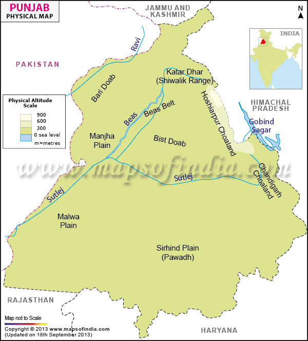
The state of Punjab rests within the geographic area between 29°30'N to 32°32'N and 73°55'E to 76°50'E. The northern Indian state of Punjab establishes its international frontier with Pakistan on one side while its domestic borders connect it to Jammu and Kashmir as well as Himachal Pradesh to the north Haryana toward the south and southeast and Rajasthan to the southwest. The strategic placement of Punjab between multiple geographic regions creates numerous climate zones thus resulting in its abundant physical diversity.
The Great Alluvial Plains
Punjab presents foremost a landmass consisting of extensive alluvial plains that form part of the Indo-Gangetic Plain which represents the largest existing tract of fertile areas worldwide. The Himalayan rivers have been continuously depositing sediments to create these plains for thousands of years. The region contains mainly flat ground that offers ideal conditions for farming operations and improves agricultural technology implementation.
Soil Fertility in the plains reveals deep rich alluvial sediments as their main characteristic. The fertile character of these soils results from the ongoing mineral supply from river irrigations. These soils make the region best suited for various crops and that is why Punjab gets its "Granary of India" nickname.
Topographical features in the plains maintain a smooth surface since elevation ranges between 180 and 300 meters above sea level. The landscape demonstrates minimal variations that produce brief elevation and depression breaks while the plains enable easy ground travel and the development of infrastructure.
The Five Rivers
According to Persian origin, "panj" (five) and "ab" (water) Punjab derived its name as "Five River Land." The state's geography and life depend heavily on the five rivers which include Sutlej, Beas, Ravi, Chenab, and Jhelum.
The Sutlej River constitutes the longest river in Punjab entering from Nangal town. Hydroelectric power and irrigation services in India receive their energy supply from the Bhakra Nangal Dam which represents one of the country's tallest gravity structures.
Punjab receives the Beas River from the Himalayas which delivers its water to Sutlej River at Harike Wetland. The river maintains multiple different ecosystems throughout its complete length.
The Ravi River delivers its water to extensive farming territories while moving along the border between India and Pakistan. India controls the distribution of water from the river through the terms of the Indus Waters Treaty.
Jhelum and Chenab Rivers mainly run through the territories of Jammu and Kashmir and Pakistan although they once belonged to Punjabi geology.
A wide range of canals extends like branches from these rivers in order to maximize agricultural irrigation potential. Among the notable canals are the Sirhind Canal together with the Bist Doab Canal.
The Shivalik Hills
In the northeast, the Shivalik Hills rise as the outermost range of the Himalayas. The hills extend over lands in Gurdaspur Hoshiarpur and District Ropar.
The Shivalik Hills maintain their elevation between 300 to 1,500 meters. The area presents challenging steep terrain found together with rugged features of narrow valleys along with gorges that locals call shoes.
Sandstone along with conglomerates forms the hills which experience frequent erosion due to their geological composition. Heavy rains trigger landslides within the region because the shallow and loose topsoil cannot retain water.
The Shivalik Hills maintain sal pine tree forests together with additional hardwood trees. The area hosts animals such as leopards and deer together with wild boar along with numerous bird species which strengthen Punjab's ecological makeup.
The Kandi Region
The Kandi belt occupies a position at the base of the Shivalik mountain range.
This topographic zone presents rolling fields and intermittent streams that create conditions for soil degradation in the area.
The local soils consist of sand and loam which have limited ability to retain water yet farming operations demand appropriate soil conservation methods.
The Kandi Region faces water shortage problems because surface runoff proceeds quickly while the recharge of groundwater remains minimal.
The Malwa Plateau
The southern and central portion of Punjab stands apart from other plains in the Malwa region.
Building elevation on the plateau surpasses plain elevations by 220 to 290 meters.
The soil composition consists of loamy to clayey levels along with parts containing calcareous materials. Agricultural productivity has experienced positive effects from irrigation despite variability in soil fertility conditions.
Vegetation: Primarily agricultural land, with pockets of natural vegetation. Cotton joins wheat alongside sugarcane when it comes to the crops grown in this region.
The Semi-Arid Southwest
Punjab changes into a semi-arid region when moving toward the southwestern direction since it faces the Thar Desert.
The region receives low rainfall between 300-400 millimeters yearly. Summer heat makes temperatures surpass 45 degrees Celsius in the area.
Sandy and less fertile soils need prolonged irrigation and extensive soil management methods in order to succeed with cultivation.
Drought-resistant species such as acacia and grasses along with natural vegetation preserve this area through its dry conditions.
Climate Variations
The climate of Punjab results from the impact of its physical geography because the region experiences severe temperate fluctuations between seasons.
Warm and dry conditions prevail across the province throughout Summer which extends from April until June. The lack of elevation in plains produces the accumulation of heat into intense levels.
The period from July to September marks the arrival of Monsoon because the southwest monsoon delivers most year-to-year rainfall. The Shivalik region receives higher rainfall because of geography-induced rain collection phenomena.
From December to February Punjab experiences cold to cool wintry weather conditions. The state experiences cold winds from the Himalayas because there are no significant geographical obstacles in its path.
The period between spring and autumn serves as a vital short window for seed planting together with agricultural collection.
Soil Diversity
Disparities in soil types throughout Punjab exist because of the effects of climatic elements and both physical characteristics and initial foundation materials.
The plains of Punjab mainly consist of deep fertile alluvial soils which were carried there by rivers. These lands contain high amounts of potassium yet they normally do not contain phosphorus and nitrogen.
Kandi Soils located in the Shivalik foothills contain poor and rocky topsoil due to their high percentage of gravel content.
Desert Soils dominate arid south-western areas of Punjab where the soil is revealed to be sandy with traces of organic material. The soil requires precise management because it has a high susceptibility to wind and water erosion.
Water Bodies and Wetlands
The territory of Punjab includes different essential wetlands and lakes extending beyond its major waterways.
A spectacular wildlife refuge called Harike Wetland exists at Beas River's meeting point with Sutlej River where numerous migrating birds arrive and multiple species flourish throughout the area.
The wetland of Kanjli exists close to Kapurthala city as part of the riverine ecosystem that sustains wildlife with its ecological resources.
The Ropar Wetland serves two key functions it recharges groundwater while providing habitat for multiple plant and animal species. It exists at a Sutlej River location.
Natural Vegetation
The natural vegetation of Punjab underwent changes due to human activities yet multiple natural habitats persist.
The state possesses 6% forested areas concentrated in the Shivalik Hills region. The most prevalent plant species in this area consist of sal, shisham along khair trees.
The grazing lands in Kandi alongside southwestern Punjab play an essential role because they stabilize the environment while sustaining animal populations.
The flora of the region consists of local medicinal plants and trees which include neem and babul species that fit well within their environment.
Fauna
Animal diversity in Punjab exists mainly in those natural environments which face less human interference.
The mammalian species in this area contain the Indian Hare alongside the Jungle Cat and the Rhesus Macaque together with the Barking Deer can be observed in forested locations.
The state functions as a vital migration route that allows Common Cranes and Siberian Cranes to move through its territory. A number of aquatic birds choose to live in wetlands.
Reptiles and Amphibians make up species that successfully inhabit both wetland and arid areas.
Geology and Mineral Resources
The geological structures of Punjab control both its geographical features alongside its resource base.
Minerals in Potash concentrations exist abundantly in the alluvial sedimentary deposits underneath the plains while serving agricultural purposes.
Shivalik Formations preserve prehistoric life fossil beds among their geological elements.
The state possesses mineral extraction sites containing the minor excavation materials limestone together with sand and gravel suitable for construction work.
Hydrology
Surface water and groundwater elements in Punjab remain critical elements for sustaining the economy which primarily relies on farming.
The state possesses abundant surface water resources from rivers together with canals. Surface water needs proper management for flood prevention and water resource equality control.
Groundwater: Significant reliance on groundwater for irrigation. The continuous removal of groundwater through over-extraction has lowered water levels thus creating sustainability risks.
The extensive canal system which includes the Indira Gandhi Canal provides additional water supply to arid areas.
Soil Erosion and Land Degradation
The environment faces various difficulties as a result of both physical elements.
Soil erosion throughout Shivalik Hills takes place because deforestation alongside steep topography lets sediment flow into rivers making them silty and decreasing soil productivity.
The southwest experiences desertification because overgrazing combines with incorrect land management practices.
Soil salinity develops because of inadequate drainage in irrigated regions which later impacts yield levels of crops.
Conservation Efforts
The solution to these problems demands several particular methods.
Forest development through tree planting serves to stabilize the land, particularly in locations with risk for erosion.
The conservation of soil requires farmers to use contour plowing along with terracing and check dams as these methods decrease surface runoff.
Water Management Promotes Efficient Irrigation Practices Through Drip Irrigation System to Achieve Water Conservation.
Impact on Agriculture
The ways by which farmers practice agriculture depend on the shape of their surrounding environment.
The fertile plains enabled multiple crop production until farmers adopted monoculture farming which negatively affected soil conditions.
The unstable amount of rainfall requires farmers to depend on irrigation for their fields. This reliance is proven by the extensive canal and tube well system.
Contemporary farming methods using high-yielding crops with mechanical equipment produced significant alterations but introduced environmental problems as a secondary effect.
Last Updated on : May 08, 2026