Bihar-Patna City Map - A closer look at Patna's History
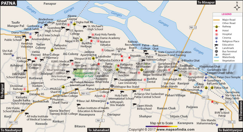
Bihar, which lies between the states of West Bengal and UP, is the 12th largest state when it comes to size. It is also a state that has got the highest number of population, and 3rd in India. Bihar is also known for the average age of people who are below 25. It accounts for 58% in the state, and also has the biggest number of proportion in India. Bihar's capital Patna is known for its early civilization and is also considered to be prime center in taking education to the next level during those times. People from all over the world came to Patna for their International Studies. Bihar-Patna city map gives a view of the Major Roads, Railways, Water Bodies, Hotels, Hospitals, Cinema Theaters, Religious Place, Education Centers, and Important Landmarks.
The view of the Ganges River that separates Bihar into two, runs from west to east, gives us a clear picture of the Son River, and Gandak River dividing the state. Patna showcases many industries that give employment to 36 lakhs people in Patna. Agriculture also plays a vital role in providing to the need of the day-to-day Patna people. Road, Rail and Air Transportation very well link Patna to other parts of the country, and the Patna Map gives a complete visual on the Railway Lines. National Highways 30, 31, 98 and 22 plays a major role in providing transportation in and out of Patna. The National Highway 31 passes through major districts and also lies in the midst of the Railway Lines from Eastern Railways.
Patna has got many tourist locations as seen on the map. As described above, tourists are still seeking Nalanda University for their education. Apart from that, there are many other notable places to visit, like the Gandhi Sangrahalaya, Museums in Jalan, Golghar, Sher Shah Suri Masjid, Srikrishna Science Center etc. All these notable tourist places can be found in the district view of the map. Even after such major developments in Bihar, it still lags in human and economic developments, which the state is trying to constantly grow. Bihar's election plays an important role in the assembly elections. Bihar is also noted in India for its fastest growing economy when compared to Delhi and Pondicherry, which are also known for their growth.
You can visit all these places with the help of the map of Patna in Bihar. It is also important to note that it has been named as the least corrupt state in the year 2011. Bihar gets quoted by articles from BBC and New York Times often as a state with tremendous improvement in women's growth, improvement in the law and order situation. The growth in the state's economy has brought in lot of opportunities. Bihar also is famous for Gandhi's first Satyagraha against the British.
Bihar-Patna city map not only gives the terrain features of the State, but it also portrays how rich the state is in terms of the Colleges, Universities, National Highways it boasts about.
Last Updated on April 17, 2026
Places to Visit in Patna
| Find Distance from Patna City Map to other Indian Cities | |||