|
|||||||||||

| |||||||||||
|
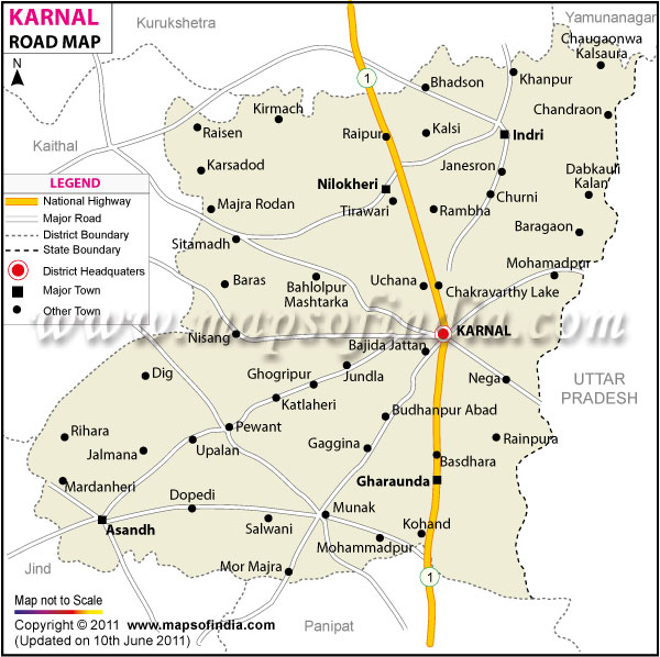
| *Map showing entire road network of Karnal district, Haryana | Disclaimer |
Haryana Roads - Karnal
Geographical Location
Karnal is counted among the important cities in Haryana. It is located at 29.68 degree North and 76.98 degree East. The place is situated at an altitude of 235 to 252 meters from the sea level. The district covers an area of 1967 square kilometers. The location is on the road that is mid-way from Delhi and Chandigarh and lies on the Delhi - Ambala Railway Line. The exact distance from Delhi to Karnal is 126 km and Chandigarh to Karnal is 126 kms.
It is a major district in the north and is well developed. It is surrounded by Uttar Pradesh to the east, Jind and Kaithat district to the west, Kurushetra district to the North West and Panipat district to the south. It lies in the fertile gangetic plains. Karnal is situated on the western bank of the Yamuna River, which forms the eastern boundary. The map which is given below can be of good help to know the details of the district and the roads that pass through various towns.
Administrative Karnal
Karnal is one of the 21 districts of the state of Haryana that is situated in Northern part of India. The district is a part of the Rohtak division. The other towns are Tirawari, Khanpur, Karsadod, Bahlolpur, Uchana, Rambha, Kalsi and many more. The district is divided into three agro climatic regions like the Khadar, Bangar and Nardak. The Karnal district has two sub-divisions, Assandh and Karnal. Further Karnal is also sub-divided into 4 teshils, Karnal, Gharaunda, Indri and Nilokheri. The 2 sub tehsils are the Nigdu and Nissing. Assansh is lone tehsil and lone subtehsil, Ballah. The provided map is a good source for visitors.
Facts of Karnal
The district has a population of 1,507, 324 in 2011. The male to female ratio is 886 for every 1000 males and literacy is 76.5%. The place is famous for the National Bureau of animal genetics research center, the Wheat Research Directorate, Sugarcane Breeding Institute; the National Dairy Research Institute is Asia's biggest dairy research institute. The various other prime attractions are the Mama Bhanja Fort, Tarori Ka Killa, Miran Sahib's tomb, Kalandar Bhanja fort, and the Church Tower. The district also has a flying club for enthusiasts.
The district is a famous trade center and therefore people from all over the country and abroad come here for various purposes. That is the reason why the roads here are well connected within the city and even to the other states as well as Delhi.
uy thi map -->