|
||||||||||
 | ||||||||||
|





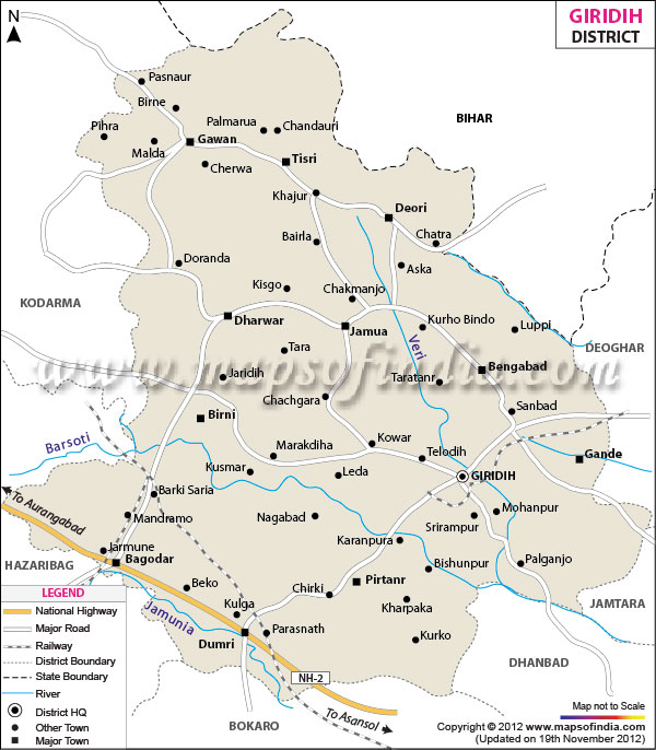
| *Giridih District Map highlights the National Highways, Major Roads, District Headquarter, etc. |
About
From Sanskrit roots "Giri," meaning hill, while "Dih" stands for land - this forms Giridih, translated directly as Land of Hills. Rising gently through northeast Jharkhand, its landscape shaped by slopes, stone ridges, because of Parasnath Hill - it claims the tallest summit in the region. Given official status as a distinct district during 1972, despite later recognition it carries weight across maps and beliefs alike. Southward connects Dhanbad district, while across the northern edge rests Bihar. At its core sits the town of Giridih - functioning as center for administration and trade. Natural landscapes meet places of worship here, alongside deposits of valuable minerals.
History and Culture
Deep within the story of Chotanagpur lies the quiet path of Giridih. Long before 1947, it rested as a segment of Hazaribagh during British oversight. Rule shifted slowly here - first through local chieftainships, then beneath Mughal reach, later folding into imperial control. By 1972, separation arrived; Giridih emerged distinct on official maps. Among India's sacred sites, one stands distinct through quiet reverence rather than grand display. Perched high, a ridge called Shikharji carries weight far beyond its stone and soil. Twenty figures central to Jain belief are said to have reached final release on this peak, lifting it above common ground. Devotees arrive each year, moving slowly upward by foot, drawn not by spectacle but depth. Their path winds past shrines scattered across the summit, modest in form yet heavy with meaning. For those who follow this tradition, few places hold greater stillness - or importance.
Festivals in Giridih represents its culture.Festivals like Durga puja Diwali,and Holi are enthusiastically celebrated while rituals like Sarhul, Karma, and Sohrai remain central to local tribes. During Paryushana, followers journey toward Parasnath Hill in large numbers Where one ends, another begins, continuity marked by rhythm of drums, scent of flowers.
Deep within tribal life, customs such as Sarhul, Karma, and Sohrai hold steady through generations. While time shifts many things, these practices endure as core markers of belonging. Such events reveal how different faiths and backgrounds share life here without friction.
Farming customs shape what people eat here - rice, lentils, alongside vegetables that change with the seasons. From deep within forests come ingredients like mahua blossoms, together with leafy plants gathered in the wild.
Economy
Among those factors shaping life in Giridih district, economic activity stands out through diverse sources. One finds agriculture forming a base, while small-scale industries add another layer. Mining contributes under different conditions, depending on resource availability. Handicrafts appear where raw materials are accessible. Trade emerges along transport routes, often near towns. Each sector operates somewhat independently, yet links form over time.
Government Sector
Among economic contributors, the government stands prominent within the district, offering jobs via administrative hubs, schools, clinics, alongside policing bodies. Employment emerges notably from district-level governance, block development units, in addition to diverse arms of state function.
Public Sector
Public sector activities shape economic life in Giridih, especially within mining and resource recovery. Rich reserves of mica, coal, and various minerals lie beneath its soil. Once ranked among the top global sources of mica, the area gained fame as India’s Mica Capital. Even though output has lessened over time, mica remains part of regional earnings.
Services Sector
Growth within Giridih’s service economy shows consistent momentum, driven by activities like trading, transport operations, finance provision, and visitor-related ventures. At the core of administrative functions, the main town supports a dense network of shops, credit providers, and monetary agencies meeting everyday community needs. Pilgrimages to Parasnath Hill shape much of the travel-based income, where lodging options, movement solutions, and goods vendors thrive due to steady footfall.
Tourism
Giridih draws those drawn to faith, green trails, or old stones. It speaks quietly - to wanderers of spirit, foot, and mind.
Among weathered stones, a stillness draws visitors inward. Quiet settles where prayers once rose. Time slows near these old shrines. Where ruins whisper old stories, rivers support present-day life. Though some come for faith, others arrive seeking solitude. Hidden paths lead beyond known landmarks. Even familiar sights shift with season and light.
Parasnath Hill (Shikharji)
Highest within Jharkhand, Parasnath Hill stands at 1,365 meters - central to Giridih’s draw for travelers. Called Shikharji or Sammed Sikhar, it holds top status among Jain holy sites across the globe. Thirty-one sanctuaries, referred to as Tonks, mark where Tirthankaras reached liberation on this summit.
A short distance beyond Giridih, Khandoti Dam forms a still body of water embraced by rising land. With boats moving quietly across its surface, the site invites calm observation.
Harihar Dham
Harihar Dham holds deep significance for those who honor Lord Shiva. Though quiet in appearance, its presence draws many seeking spiritual connection. While rooted in tradition, the site remains active with daily rituals. Because of its location, visitors often arrive early, before sunlight touches the stone steps. Even without grand architecture, the atmosphere carries weight.
Langta Baba Samadhi Sthal
A quiet atmosphere surrounds the location, which honors a well-known holy figure. Visitors come here, drawn by its sacred meaning rather than mere curiosity. Though removed from busy areas, it remains active with moments of silent prayer. Because of its history, many choose to pause and observe personal rituals on these grounds.
Jharkhand Dham
Found within the district, Jharkhand Dham carries spiritual weight among Hindu followers while shaping patterns in regional pilgrimage travel. Though lesser known, its presence quietly supports broader networks tied to faith-based journeys across the area.
Demographics
Spread across a broad area, Giridih ranks among the densely inhabited regions of Jharkhand due to available livelihood options. Though spread unevenly, people cluster more densely near towns and city zones than elsewhere. Where built-up areas end, numbers thin out noticeably.
In 2011, Giridih had population of 2,445,474 of which male and female were 1,258,098 and 1,187,376 respectively .Though male reading proficiency showed stronger results, females trailed behind - a difference still being narrowed by public programs today. Average literacy rate of Giridih in 2011 were 63.14 compared to 63.14 of 2001.
With regards to Sex Ratio in Giridih, it stood at 944 per 1000 male compared to 2001 census figure of 982. The average national sex ratio in India is 940 as per latest reports of Census 2011 Directorate. In 2011 census, child sex ratio is 942 girls per 1000 boys compared to figure of 978 girls per 1000 boys of 2001 census data.
The Urban population of Giridih District is 2.08 Lac (2,08,024), with 1.08 Lac (1,08,490) being males and 99.53 k (99,534) being females, making up 8.51% of the Giridih total population, The sex ratio in urban population is 918 females for every 1000 males.
The Rural population of Giridih District is 22.37 Lac (22,37,450), with 11.50 Lac (11,49,608) being males and 10.88 Lac (10,87,842) being females, making up 91.49% of the Giridih total population, The sex ratio in rural population is 947 females for every 1000 males.
In Giridih, most people speak Hindi when they talk every day. This language influences how officials run things. Schools teach lessons mainly in it. Business dealings often happen using these words.
Among certain groups, Urdu finds regular use. Where people live shapes which words they speak. This mix of speech forms mirrors the makeup of local populations.
Administration
Within Giridih district, administration follows a setup designed for steady function. Governance flows through arrangements meant to support public needs without disruption. Service reaches residents by pathways built on structured roles. Organization here serves routine operation above all else.
Giridih district splits into three administrative units known as tehsils. These sections help manage governance more efficiently across varied regions. Each subdivision operates under a defined structure to support local administration
Giridih Sadar, Dhanwar, Dumri.
Within each subdivision, blocks form the core framework for managing rural governance and guiding growth. Thirteen such areas exist inside the district. Among them are Giridih, followed by Bengabad, then Birni. Deori appears next on the list, along with Dhanwar. One finds Dumri situated nearby, while Gande lies apart. Gawan occupies another sector, whereas Jamua takes a separate place. Pirtand stands distinct, as does Bagodar. Tisri emerges later in sequence, ending with Suriyā.
Across Giridih district lie around 2,590 villages, scattered throughout the countryside. Size shifts sharply from one settlement to another, along with differences in people and available services. Most inhabitants live outside towns, working mainly on farms or related tasks.
Governance at this level functions via Gram Panchayats - locally elected bodies handling community matters. Administration rooted here forms the base layer of rural decision-making.
| GIRIDIH DISTRICT PROFILE | |
|---|---|
| COUNTRY | INDIA |
| STATE | JHARKHAND |
| AREA | 4,845 sq km |
| DISTRICT HEADQUARTERS | Giridih |
| ASSEMBLY SEATS | 6 |
| Population | 2,445,474 |
| Language | Hindi |
| LITERACY RATE (% age) | |
| Male | 79.08 |
| Females | 50.33 |
FAQs
Q1: How many villages are there in the district?
Among the landscape of Giridih district, around 2,590 villages lie scattered throughout its 13 administrative divisions.
Q2: What is the population of the district?
Population figures for Giridih district stand at roughly 2.44 million based on the 2011 census data. More recent approximations indicate a rise beyond 2.8 million individuals residing there. This places Giridih among Jharkhand's more densely populated regions. Growth patterns reflect shifts seen across similar administrative zones.
Q3: What is this district famous for?
Giridih draws attention mainly because of Parasnath Hill - called Shikharji - a sacred place for Jain followers, standing tall as Jharkhand’s loftiest summit. Once widely recognized across the nation, it earned the label “Mica Capital of India,” backed by vast layers of mica beneath the land. Scenery shaped by forests, hills, and water bodies marks much of its terrain. Among quiet streams and green slopes rise spots such as Usri Falls, where nature unfolds without hurry. Culture thrives here through many tribal communities whose traditions remain rooted in older ways. Another point of note is Khandoli Dam, formed behind a broad barrier that holds still waters. Richness lies not only underground but also in how life movies slowly ,visibly.
Last Updated on : May 11, 2026
