|
||||||||||
 | ||||||||||
|





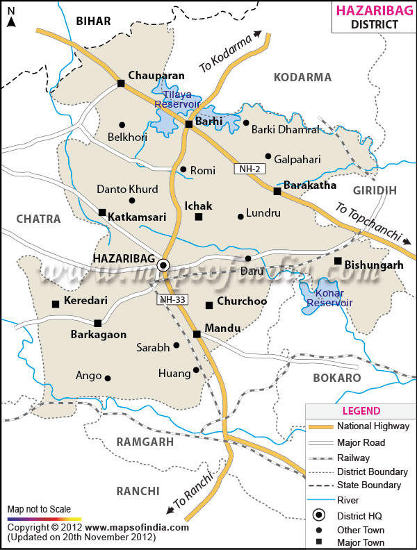
| *Hazaribagh District Map highlights the National Highways, Major Roads, District Headquarter, etc. |
About
Hazaribagh district sits in northern Jharkhand, standing out for deep roots in history and striking natural scenery. With thick forests wrapping around rolling hills, scattered lakes, and flat elevated land, the place draws notice - not through noise, but calm presence. Often praised for mild weather, it hosts schools that matter, shelters diverse animals, and holds stories from centuries past. Part of the Chota Nagpur Plateau, this area blends green cover with human tradition without forcing either aside.
Often thought to translate as "thousand gardens," the term “Hazaribagh” points to lush landscapes that once marked the region. With time, the town at the district's heart grew into a hub for governance and learning. Infrastructure upgrades over time played a quiet but steady part in this shift. In towns, wider North Indian patterns mix subtly with native ways. Even now, local fairs draw people beyond mere festivity into inherited forms. Through these moments, older expressions find room to stay alive.
History and Culture
Deep roots tie Hazaribagh’s past to the Chota Nagpur Plateau, shaped by generations of tribal presence. Well prior to cities or governance frameworks, people native to these lands made homes here. Survival came through farming, forest use, and gathering what nature provided. Life unfolded around customs marked by seasons, guided by shared beliefs. Villages thrived under local leadership, built on collective ways of living.
Gradually, the area rose in significance through medieval and colonial times thanks to its advantageous position alongside a pleasant weather pattern. Under British control, Hazaribagh began shifting toward governance functions, earning recognition for more agreeable living conditions when contrasted with hotter plains below. Authorities built schools, pathways, and government buildings across the zone, fueling expansion within the main settlement. Owing to milder temperatures plus attractive landscapes, housing zones and imperial-era facilities started taking shape throughout the hills.
The district has given many freedom leaders who participated in India's freedom struggle. Instead of fading into obscurity like others, its prison became notable after a daring departure orchestrated by Jayaprakash Narayan alongside companions. The escape led to anger which grew on a large scale during the Quit India Movement.
Hazari bagh's culture grows from both indigenous practices and wider regional currents. While Santhals shape many rituals, Oraons add depth through song forms passed across generations. Music surfaces in daily life, not just staged events, especially where elders lead communal gatherings. During festival times, Munda contributions stand out, their rhythms guiding night-long performances. Dance appears most vividly in villages, rooted more in memory than choreography. These expressions survive not because they are preserved, but because they shift quietly with time.
Painting walls becomes an act of memory in Hazaribagh’s countryside, where villagers shape stories through color and line. With festivals come these murals - built from earth tones, drawn freehand into spirals, squares, and flowing shapes that echo trees, birds, yet unseen spirits too. Not studios or galleries but courtyards hold this practice alive; hands passing down what pigments remember. Often it is women who mix the paints, stretch arms across mud surfaces, guide rhythm into every stroke without speaking rules aloud.
Among the hills, daily eating habits grow from both ancestral knowledge and nearby land offerings. While rice fills most plates, lentils simmer alongside greens gathered close by. From thick forests come recipes passed through generations, still found across village homes. Though times change, meals made with native plants stay common in remote spots. Millets shape much of what people eat, often mixed with wild-seasoned touches.
Economy
Hazaribagh's economy draws strength from farming, mineral extraction, commerce, learning institutions, and service work. In villages, many people make their living through cultivating land or raising animals. Grown widely across fields, paddy stands out as the dominant harvest. Other crops appear too - wheat, maize, pulses, oil-bearing seeds, and various vegetables - shaped by weather patterns and earth quality nearby. Though diverse, these efforts reflect how nature guides what grows here.
Farming thrives in the region's rich valleys, thanks to periodic rains - yet success often hinges on monsoon patterns. While crop cultivation dominates, raising cows for milk adds steady earnings across villages; chickens and animals also contribute where fields alone fall short.
Deep within Jharkhand's resource-heavy corridor sits Hazaribagh, where digging for minerals shapes part of daily economic life. Jobs have emerged near coal sites outside town - drivers move goods, workers find roles, factories link up. Though industry hums nearby, this place hasn’t tipped fully into city-scale growth like others; instead, villages and towns hold their own. While extraction brings change, the balance between countryside and settlement remains noticeable here.
Government Sector
Most people see government work as a solid career path, thanks to steady paychecks and respect in society. Starting at local offices, moving into schools or hospitals, these roles cover many areas of daily life. Stability pulls applicants - fewer worries about sudden job loss than in private firms. From teaching to policing, services rely on public employees to function smoothly. Communities trust officials handling records, taxes, and emergency response. Progress happens step by step, promotion after promotion over years. Such positions shape how citizens experience governance every day.
Public Sector
Public banks, schools, transit systems, clinics, and community development centers quietly influence economic conditions across the region. Improved infrastructure, wider electricity availability, coupled with focused support programs, have slowly enhanced access and daily life for residents.
Services Sector
Nowhere more visible than in Hazaribagh town is the gradual rise of service-based work across neighboring towns. Instead of factories, shops that sell goods have become common sources of jobs. Coaching centers prepare young learners for exams, forming a growing share of daily economic activity. Private education providers operate alongside these, drawing families who seek alternatives.
Tourism
Among Jharkhand's key travel spots, Hazaribagh stands out due to forested areas, rolling terrain, animals in their habitat, water bodies, along with traces of past eras. Cooler temperatures, paired with green landscapes, draw those wanting calm views and quiet settings.
Home to dense woods and native animals, Hazaribagh Wildlife Sanctuary stands out across the region. Over the years, animal populations shifted - yet visitors still come for quiet trails beneath tall trees. Its value grows not just from species present, but from moments of stillness found between branches. Even as patterns shift, the place holds steady appeal for those drawn outdoors.
Perched above the town, Canary Hill draws crowds eager to see what lies beyond its winding path. From up top, eyes meet wide stretches of rolling terrain shaped by quiet winds. A favorite among those with cameras, the summit rewards stillness with unbroken horizons. Trees frame the edges, softening the sky’s edge with layers of leaf and light. Few places in the city stand out like this rise does, quietly claiming attention without demand.
Lake Hazaribagh sits right inside the town, drawing plenty of visitors. With greenery wrapping around it and wide stretches of open land nearby, people often come here just to unwind - locals along with travelers. What makes it stand out isn’t grand design but quiet accessibility.
Among its features are temples, buildings from the colonial period, while rolling rural landscapes mark deeper roots in history and culture. What adds momentum to travel interest? Community events and seasonal gatherings draw people keen on local ways of life, not just sightseeing.
Demographics
Some 17 lakh individuals inhabit Hazaribagh district, as recorded in the 2011 Census. While towns add to its makeup, most residents remain settled in village settings across the area. Across the district, Hindi dominates as the main spoken language, though tribal tongues appear in village settings. Rural regions see frequent use of local dialects alongside these native forms of speech. An essential segment of the area's demographic makeup comes from indigenous groups. Their presence shapes much of the region’s social character and heritage.
Though not the highest in the region, about 70% of people in Hazaribagh can read and write. Because of steady growth in schooling, more individuals now access learning opportunities. Schools, along with colleges, have slowly built stronger community engagement with education. Their presence has quietly shifted attitudes over time - knowledge matters more today.
Administration
Split into multiple blocks and subdivisions, Hazaribagh district organizes its administration and planning this way. Acting as the core hub, the town of Hazaribagh hosts the main offices and leads district-level functions. Among the key administrative zones are Hazaribagh, followed by Barhi and Barkagaon. Katkamdag appears alongside Bishnugarh in official listings. Ichak turns up frequently in regional records. Then there is Daru, often mentioned with Padma. Churchu forms part of this structure too. Lastly, Chauparan completes the group.
Spread out over plateaus, farmlands, and woods, the area includes well over thirteen hundred small settlements. Governance at ground level, progress initiatives, yet social support systems rely heavily on village councils shaped by tradition. Among key goals sit better schools alongside clinics within reach. Road links get attention through upgrades that connect villages more directly. Protection of forests blends into efforts shaping cleaner rivers. Farm support appears in programs adjusting to seasonal shifts. Village progress ties back to systems delivering water and power steadily.
| HAZARIBAGH DISTRICT PROFILE | |
|---|---|
| COUNTRY | INDIA |
| STATE | JHARKHAND |
| AREA | 3555 sq km |
| DISTRICT HEADQUARTERS | Hazaribagh |
| ASSEMBLY SEATS | 5 |
| Population | 1734495 |
| Language | Hindi, Urdu, English |
| LITERACY RATE (% age) | |
| Male | 81.15 |
| Females | 59.25 |
FAQs
Q1: How many villages are there in the district?
Across the administrative blocks of Hazaribagh district, over 1,300 villages are located.
Q2: What is the population of the district?
1734495 people live in Hazaribagh district, as recorded during the 2011 census.
Q3: What is this district famous for?
One can find rolling hills across the district. There are lush forests, and vivid natural scenery. The Hazaribagh wildlife sanctuary located here has wild cats moving quietly along with birds that fill the air with sound. Vinoba Bhave University is also a renowned university located here.
Last Updated on : May 11, 2026
