|
||||||||||
 | ||||||||||
|





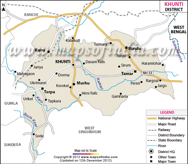
| *Khunti District Map highlights the National Highways, Major Roads, District Headquarter, etc. |
About
Khunti is one of the tribal districts of Jharkhand state, India. It is famous for its rich tribal tradition, natural beauty, forest and its association in the memory of the great tribal freedom fighter Birsa Munda. The phrase khunti district map is used quite frequently while discussing the geography, administration and development of the district, which could be said to constitute an important part of the tribal belt of Jharkhand.
The area of the district is about 2535 sq. Km. and the district is surrounded by the district of Ranchi, Gumla, Simdega and West Singhbhum. The topography of the Khunti area is hilly, fertile valleys, forests in the plateau. The agricultural industry is still the main economic pillar and forest products and traditional livelihoods of the tribes occupy a large part of daily life. The overall Khunti district map may be useful for infrastructure planning, Rural Development and the Tourism development in Khunti district.
History and Culture
Historians accord a high value to Khunti as it is tightly linked with the tribal revolts against the British colonialism. It is said that it is the birth territory of Birsa Munda, leader of the famous Ulgulan movement of late 19th century and it is known as "Land of the Mundas. The name Birsa Munda of the tribals became a symbol of their context of identity, resistance and the struggle for social reform. He fought for resisting the exploitation of land policies and colonial administration and still his battle is an inspiration for tribal people throughout India. The Khunti district map therefore not only functions as a reference, but also as a symbol of an important tribal identity and resistance hotspot.
The region has been a part of the Chotanagpur Kingdom and during its British rule became a part of British India. Most of the cases of tribal disturbances are due to the exploitation of tribal land and forest resources. The changes in traditional land ownership brought into by the British revenues ended traditional harmony among the indigenous people and led to a breakdown in harmony. The map of the district also got an uptick in its value once the Khunti district was officially formed in September 2007 with a mission of improving the governance and development in the majority tribal region.
The culture of Khunti is a mixture of Munda and Oraon tribe's culture. Traditional activities like festivals, dances, folk songs and enactment of customs still have a role in the day to day life of the tribes. In festivals and harvest times traditional dances are performed, called Paika and Jadur enjoyably. Sarhul, Sohrai, Mage Parab, Karma and Tusu are the most popular festivals of the district. These festivities of course are intimately linked to nature, agriculture and ancestor worship. Due to its cultural and anthropological value, the Khunti district map is often called on for research purpose showing the settlement of tribal people and cultural centres in the district.
Many villages can be found with traditional tribal architecture and bamboo crafts, woodwork and indigenous agricultural methods. Other tribal languages use such as Mundari are still employed, apart from Hindi and Nagpuri. Harvest, wedding ceremonies and festivals are times where music is an integral part of the community. The local food products includes products from rice field, forest food products and local drinks prepared during a festive event and ceremony. The district also has sacred gardens, and traditional customs of nature, which are directly linked with the relationship of the tribal communities with nature. Thus, the Khunti district map takes on particular significance and importance from the administrative and cultural geography of the tribal heartland of Jharkhand, not only because of its border areas along with other district but also because of its cultural geographic significance.
Economy
The majority of economy in Khunti district is agro based and forest based activities contribute to the livelihood of a significant portion of the population. Paddy, maize, pulses and oilseeds are some of the common crops and lac production is also quite significant along with collection of forest produce contributing to livelihood of the rural people. Agricultural zones, irrigation projects and forest areas, are critical to support the rural economy in terms of food production, employment, as well as dependence and contribution to the economy of the Khunti district.
The government sector is an important contributor to the economic fabric in the district. The Government departments such as education, health services, agricultural and rural development, public works and tribal welfare offer significant employment avenues. The district enjoys the implementation of several tribal welfare and development schemes of the government at the State and Central levels pertaining to rural houses, roads and agriculture. Various other administrative offices, schools, health care centres and panchayati raj institutions result in job creation and provision of public services. The Khunti district map is used commonly in developmental planning and implementation in blocks and villages regarding welfare programmes.
The economy of the district is also fuelled from the public sector with projects like extension of infrastructure, electrification of rural areas, transport connectivity and public financial institutions projects. Farmers participate in cooperative societies and benefit from government sponsored agricultural programs to fuel productivity improvements and also to get them better markets. Many tribal households continue to depend on their forest resources for livelihoods like lac, mahua flowers, tendu leaves and timber. The Khunti district map facilitates forest business and administration, land records, and development planning infrastructure expansion in the remote location of the district.
In the past couple of years, due to the advancement of education, communication, retail trade, transport and banking services, the industry of services has been steadily growing. There are new fields that have become employment avenues for educational institutions, health services, small businesses, tourism and transport services. Weekly tribal markets or haats continue to be significant markets for exchange and sale of the agricultural and forest products locally. The importance of the Khunti district map has grown in terms of doing tourist promotion, various kinds of road connectivity projects and identification of commercial growth centres within the district.
Tourism
The scenic beauty, the water falls, forests and the places associated with the tribal history make Khunti district popular. Ulihatu village is one of the most important tourist destinations, where Birsa Munda was born. People from all over India visit the village to understand the life and legacy of this great chief of tribals of the region. The map of Khunti district has been sourced by literally all the tourists and researchers who come to visit the places and areas related to the life of Birsa Munda and his involvement in the revolution.
One of most visited places in the district is Panchghagh falls. The waterfall is formed by several streams of water, which fall over rocks and through vegetation.There are numerous trees and rocks around the waterfall, and it appears to be a series of streams leading into one stream. The quiet ambiance and natural beauty have traditionally been the reasons for the visitors, especially in the monsoons. Perwaghagh Falls is also a waterfall, and is as scenic as it is natural. The area is also endowed with diverse forests, river and platelet scenic topography that are attractive to eco-tourists and nature enthusiasts. All Natural attractions that can be reached from the nearby villages on Khunti district map.
There are also other significant places to visit such as the memorial site of Dombari Buru, the Ulgulan movement, living tribal villages and local weekly markets, where you can see local arts and crafts. There of course are religious and cultural sites that have religious beliefs that relate to tribal beliefs as well, that attract people who want to learn about anthropology and cultural tourism. In contrast to the urban destinations, the district's offer of tourism is quite unique because of the rural landscape and traditional festivals, as well as the rich tribal culture, that will give unforgettable experiences to visitors. The district map of Khunti has been a great tool for people interested in exploring the district's historical monuments, Waterfalls, forest areas and Cultural centres.
Demographics
According to the last population count in 2011 Khunti district has population of approximately 531,885. The sex ratio in the district is comparatively good, around 997 females per 1000 males, and is one of the better ratios, in Jharkhand. The district is one of those districts which has high percentage of tribal population, predominantly from the Scheduled Tribes, particularly the Mundas who reside in the district. The general use of the Khunti district map is in demographic studies for looking at settlement patterns, Tribal settlement/indications of rural development.
The literacy rate of the district is around 63.86 per cent. Though in recent decades, the government's initiatives and increasing in schools that children and young people could access has helped to raise the proportion of men and women studying. Hindi is the language used in administration and communication and the local communities use the Mundari, Nagpuri and the regional tribal dialects. Rural areas are home to the majority of the population, and farming is closely associated with the population and settlement structure.
Administration
It is administered in Jharkhand as Khunti district. The district consists of one subdivision and several community blocks namely Khunti, Karra, Murhu, Torpa, Rania and Arki. These administrative divisions are responsible for the governance, and implementing the welfare schemes and local development work. The Khunti district map is an integral means of administration and is used for governance, land use management, census and infrastructure planning in Khunti district.
The district has the quantity of around 756 villages, of which majority are inhabited rural settlements. There are panchayat raj institutions which are in an active state in villages and blocks to help rural development and decentralised administration. Police offices, health centers, schools and block offices are situated throughout the district for greater accessibility and governance in more remote areas of the tribal region. Roads in recent years have become better connected with some interiors relying on rural transport infrastructure for communication and trade, but digital infrastructure has also improved.
| KHUNTI DISTRICT PROFILE | |
|---|---|
| COUNTRY | INDIA |
| STATE | JHARKHAND |
| AREA | 2,467 sq km |
| DISTRICT HEADQUARTERS | Khunti |
| ASSEMBLY SEATS | |
| POPULATION | |
| Total | 530299 |
| Male | 265939 |
| Females | 264360 |
| Density/km2 | 215 |
| Sex Ratio | 994 |
| LITERACY RATE (% age) | |
| Male | 75.33 |
| Females | 53.71 |
FAQs
Q1: How many villages are there in the district?
Khunti district has around 756 villages.
Q2: What is the population of the district?
According to the 2011 Census, Khunti district has a population of approximately 531,885 people.
Q3: What is this district famous for?
Khunti district is famous for its association with Birsa Munda, tribal culture, waterfalls, and historical significance in the tribal freedom movement.
Last Updated on : May 11, 2026
