The 8 Mizoram Districts are
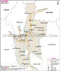
-Aizawl - (Area - 3577 km2, Population - 404,054)
Its headquarters is Aizawl city which is also the state's capital. It's the most populated district of Mizoram. The district has 5 Rural Development Blocks and 14 legislative assembly constituencies.
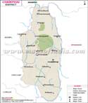
Champhai - (Area - 3186 km2, Population - 125,370)
Its headquarters is Champhai town. The district comprises of 4 Rural Development Blocks, 5 Legislative Assembly constituencies and 88 inhabited villages. It also houses the Murlen National Park and Lengteng Wildlife Sanctuary.
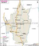
Kolasib - (Area - 1382 km2, Population - 83,054)
Its headquarters is Kolasib town. The district has 2 Rural Development Blocks and 3 assembly constituencies.
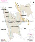
Lawngtlai - (Area - 2557 km2, Population - 117,444)
Its headquarters is Lawngtlai town. The district has 2 Autonomous Councils, 4 Rural Development Blocks, 3 Legislative Assembly constituencies and 158 villages. It also houses the Ngengpui Wildlife Sanctuary.
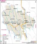
Lunglei - (Area - 4538 km2, Population - 154,094)
Its headquarters is Lunglei town and is the second most populated in the state. The district has 4 Rural Development Blocks and 7 assembly constituencies.
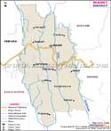
Mamit - (Area - 3026 km2, Population - 85,757)
Its headquarters is Mamit town. The district has 4 Rural Development Blocks and 3 legislative assembly constituencies. It also houses the Dampa Tiger Reserve
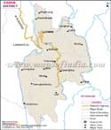
Saiha - (Area - 1400 km2, Population - 56,366)
Its headquarters is Saiha town. The district has 3 Rural Development Blocks and 3 assembly constituencies. It also houses the Phawngpui Blue Mountain National Park.
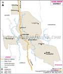
Serchhip - (Area - 1422 km2, Population - 64,875)
Its headquarters is Serchhip town. The district has 3 sub-divisions and 3 legislative assembly constituencies. It also houses the Khawnglung Wildlife Sanctuary.
List of Districts in Mizoram
| Sr. No. | District | District HQ | Population (2011) | Growth | Sex Ratio | Literacy | Area (km2) | Density (/km2) |
|---|---|---|---|---|---|---|---|---|
| 1 | Aizawl | Aizawl | 400309 | 22.92% | 1009 | 97.89 | 3577 | 113 |
| 2 | Champhai | Champhai | 125745 | 16.01% | 984 | 95.91 | 3168 | 39 |
| 3 | Kolasib | Kolasib | 83955 | 27.28% | 956 | 93.5 | 1386 | 60 |
| 4 | Lawngtlai | Lawngtlai | 117894 | 60.14% | 945 | 65.88 | 2519 | 46 |
| 5 | Lunglei | Lunglei | 161428 | 17.64% | 947 | 88.86 | 4572 | 34 |
| 6 | Mamit | Mamit | 86364 | 37.56% | 927 | 84.93 | 2967 | 28 |
| 7 | Saiha | Saiha | 56574 | -7.34% | 979 | 90.01 | 1414 | 40 |
| 8 | Serchhip | Serchhip | 64937 | 20.56% | 977 | 97.91 | 1424 | 46 |
Last Updated on : June 24, 2026