|
||||||||||
 | ||||||||||
|





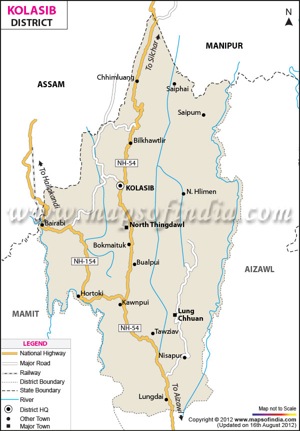
| *Kolasib District Map highlights the National Highways, Major Roads, District Headquarter, etc in Kolasib. |
About
Kolasib district sits in the Aizawl Mountainous Region of the Eastern Hill Zones. The land of Kolasib district is rough with hill slopes. The lower hill ranges in Kolasib district run from north to south and are crossed by strips of plain land. The average height of Kolasib district is 722 meters (2,370 feet). Kolasib district has one finished hydroelectric dam, Serlui B Dam and another dam, Tuirial Dam is being built as of September 2011.
Kolasib district has a rivers and many streams and rivulets that vary in shape and length. Most of these streams and rivulets in Kolasib district are temporary. Because the drainage system of Kolasib district depends mainly on natural water paths and the shape of the land scientists studied the drainage of Kolasib district using satellite images and Survey of India maps.
History & Culture
Kolasib district is a district. It sits on the tip of Mizoram and shares its northern border with Cachar District in Assam. Kolasib district was formed in 1998 when it was taken out of Aizawl district. Kolasib district was created by upgrading the existing sub‑division of Aizawl district as stated in Government Notification No. A.60011/21/95‑GAD dated 29 July 1998. Two Rural Development Blocks, N. Thingdawl and part of Tlangnuam cover the whole of Kolasib district. Later Kolasib district was split into three sub‑divisions:
- Vairengte Sub‑Division, whose headquarters are at Vairengte.
- Kawnpui Sub‑Division, whose headquarters are at Kawnpui.
- Kolasib Sadar Sub‑Division, whose headquarters are at Kolasib.
Because there are no written records or any other authentic documents like all districts in Mizoram nothing is truly known about the ancient or medieval history of Kolasib district. Written records were kept only after the British ruled the area in the half of the nineteenth century. It can be said that during the four centuries and even after the British came to Kolasib district the system of chieftainship was common in the region. In Kolasib district a chief named Kawla ruled the village that is now called Kolasib. When people talked about that village they called it "Kawla Chief Village." The British named the place Kolasib after Kawla Chief. The name has not changed since then.
Kolasib district sits on the tip of Mizoram. Kolasib district was carved out of Aizawl district in 1998 as stated in Government of Mizoram Notification No. A.60011/21/95‑GAD dated 29 July 1998. Before becoming a district Kolasib was a sub‑division under Kolasib Sadar Sub‑Division, whose headquarterss at Kolasib. Kolasib district has two sub‑divisions: Kawnpui Civil Sub‑Division and Vairengte Civil Sub‑Division. By the end of 2001 Kawnpui Civil Sub‑Division was not functioning. As for Rural Development Blocks, the whole of Kolasib district is covered by Thingdawl and part of Tlangnuam R.D. Block. The Deputy Commissioner of Kolasib district is the civil officer who is helped by the Superintendent of Police and other district and R.D. Block officers to run everyday administration and development in Kolasib district.
Economy
Kolasib district has an economy that depends mainly on agriculture with some jobs in services because Kolasib district is the district capital. Many people in Kolasib district grow beetle nut, oil palms, rice, wheat and fish. Kolasib district produces these items for use and also sells them to other districts in Mizoram.
In Kolasib district 41.3% of workers aged 15 and older work in agriculture, forestry or fishing compared to 47.7% in an Indian district. Kolasib district has 3,074 registered MSMEs while a typical Indian district has 38,876. In Kolasib district 78% of MSMEs are in services. 22% Are in manufacturing whereas in a typical district the split is 76% services and 24% manufacturing. Small and medium enterprises provide 2.1% of MSME employment in Kolasib compared to 3.3% in a district. EPFO covers 0.2% of the labour force in Kolasib, versus 2.1% in a typical district. Bank deposits per person in Kolasib are ₹41,997 while in a district they are ₹59,112. Kolasib district’s Ministry of Food Processing Industries One District One Product is Turmeric. School enrolment for students in classes 9 to 12 in Kolasib district is 68.2% of the population of that age compared to 66.9%, in a district.
Tourism
Serlui B Lake
The picturesque Serlui lake lies about an hour drive from Kolasib Town. Serlui lake is a weekend destination. Serlui lake was formed when the dam of the Serlui Hydel Project was built. The river that feeds Serlui lake goes upriver. Bends through the valley of River Serlui. Serlui lake spreads into pools at many points inside thick forests and between green hills. The 53 km long flooding of the valley can be seen from the NH-54. The Department of Tourism has built a places to stay and they will open soon. Plans are also being made for water sport facilities and an Eco‑Tourism centre. The Department of Tourism has also built a fish farm using the dam as its base. I think Serlui lake is a gem that I would love to visit again.
Tuilut
Tuilut is located in Kolasib. Some caves in Mizoram are still unexplored. They are full of mystery and superstitions. One of them is Bak Puk, also known as Tuilut. Tuilut is at Project Veng within the town of Kolasib 83 km from Aizawl City which's about two and a half hours drive away. With its vertical entrance that draws in rainwater Tuilut looks more like a sinkhole.. The tunnel later opens into wide caverns with amazing rock shapes and deep pools that have not been fully explored with proper gear. The fact that the cave system has no known exit is amazing so people say the whole town sits on top of a lake. Because of this belief no one dared to explore Tuilut until recently. On January 2016 a group of adventurers called "Zotrek" went to explore Tuilut. They went to a depth of 100 meters. Found beautiful rock shapes with many chambers.
Pualreng Wildlife Sanctuary
The fringe villages of Pualreng Wildlife Sanctuary are N. Hlimen, Thingthelh, Bukpui, Palsang, Zohmun and N. Khawdungsei. Birds found in Pualreng Wildlife Sanctuary include the Indian hornbill (Vapual) Wreathed Hornbill (Kawlhawk) Pied hornbill (Vahai) Khaleeej Pheasant (Vahrit) Bhutan peacock pheasant (Varihaw) Red jungle fowl (Ramar) White cheeked partridge (Varung) and many others. Many wild animals live in Pualreng Wildlife Sanctuary. Arboreal animals such as Hoolock gibbon (Hauhuk) Slow loris (Sahuai) Common Langur (Ngau) Rhesus macaque, etc. Large animals such as black bear (Savawm) Leopard (Keite) Sambar (SDazuk) Barking Deer (Sakhi) Binturong (Zamphu) Chinese pangolin (Saphu) and many others also live there.
Lung Nupa Bualpui
Lung Nupa in Bualpui at Kolasib District! Be an explorer of a destination and step outside your comfort zone for unlimited adventure, to remote areas and possibly hostile destinations.
Demographics
In the 2011 Census of India report Kolasib district had a population of 83,054. In the district most people live in villages as opposed to in towns. Also in the district agriculture, horticulture and forestry still support many families.
The district is home to a predominantly Mizo population. Mizo communities play a key role in our society and also influence local cultures, languages and traditional practices.
Mizo is a very common language here which is used widely, also we see that English and other local languages are used in day to day communication. This social make up of the district is what we see.
Kolasib town is the primary urban center. In the outlying areas you will find smaller towns and market centers which in turn connect nearby villages to educational and health care resources as well as government offices.
The district has seen progressive growth in education and health. Government programs and welfare schemes have improved access to schools, hospitals and other public services.
Administration
Kolasib is run by the Deputy Commissioner and District Magistrate. The district administration runs public services, development projects, revenue matters, law and order and welfare programs.
According to the district administration Kolasib has 3 sub-divisions and 2 Rural Development Blocks which in turn run the administration for the district.
The district has village-level administrative bodies which carry out many village level development projects and local administration.
Kolasib has local urban administrative bodies which in turn run roads, sanitation, drainage, water supply and waste management.
The district is home to 39 villages according to the district profile which is a mark of its rural character. Local government bodies work with the government departments to implement development programs in these villages. The two Rural Development Blocks are Thingdawl and Bilkhawthlir.
| Facts of Kolasib District | |
|---|---|
| State | Mizoram |
| Population | 83,054 |
| Area | 1,472.12 km² |
| Language | Mizo, English and other local languages |
| Religion | Christianity and other religious beliefs |
FAQs
Q.1: Is Kolasib mostly urban or rural?
Kolasib is a largely rural district. In which the majority of the population lives in villages.
Q.2: What languages are spoken in Kolasib?
Mizo is a very popular language in that district. Also many communities use English and other local languages.
Q.3: Which places should one visit in Kolasib?
Tamdil Lake, Vairengte and the scenic landscapes around Kolasib are popular attractions in the district.
Q.4: What is Mizo culture's role in Kolasib?
Mizo communities have been the formulators of the district’s traditions, festivals, music, dance and social practices for generations.
Q.5: Why is Tamdil Lake important?
Tamdil Lake is a popular natural attraction for visitors. Also it is what may term a notable tourist destination in Mizoram.
Last Updated on : November 17, 2026
