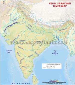
The Ghaggar-Hakra River, also known as the Saraswati River, is a trans-boundary river in India and Pakistan. The river runs in both the nations only in the monsoon season. Prior to the Ottu barrage, the name of the river is Ghaggar and after it crosses the barrage, it is named as the Hakra downstream. The Saraswati or Ghaggar-Hakra River is normally denoted as the Sarasvati River in the Vedas by majority of researchers. Nevertheless, there is a debate that whether all quotations to the Sarasvati in the Rig Vedas should be utilized to denote this river. Scholars like Jane Macintosh, C.F. Oldham, Marc Aurel Stein, Max Müller, and Christian Lassen have acknowledged the recognition of the Vedic Sarasvati River with the Ghaggar-Hakra River.
The Saraswati River: An Overview
The Ghaggar River:
The Ghaggar is a trans-boundary river in India, running during the monsoon season. The source of the river is located in the Shivalik Mountains of Himachal Pradesh. The river runs through Punjab and Haryana states and penetrates Rajasthan; merely southwest of Sirsa in Haryana and alongside Talwara Jheel in Rajasthan. This recurrent river supplies two irrigation channels that stretch into Rajasthan.
The contemporary Sarsuti (Saraswati River) has its source at the foothills of a mountainous area in the Ambala district (Haryana) and meets the Ghaggar close to Shatrana in Punjab. A dehydrated waterway of the Sutlej meets the Ghaggar close to Sadulgarh (Hanumangarh) and the name of the conduit is the Naiwal canal. The Ghaggar is subsequently joined by the desiccated Chautang (Drishadvati) river in the vicinity of Suratgarh.
The broad paleochannel or riverbed of the Ghaggar River implies that at one time, the river was running with full strength during the famous liquefaction of the Ice Age glaciers in the Himalayan Mountain Ranges about 10,000 years back, and it subsequently went on across the whole area, in the currently waterless canal of the Hakra River, probably pouring into the Rann of Kutch.
The river apparently got dehydrated because of the detention of the tributaries by the Yamuna River and Indus River System, and afterward, moreover, the desiccation in most of its drainage basin because of cutting down of trees and overgrazing. Some researchers thought this to have taken place at the most recent in 1900 BCE, however it originally happened much before.
Verma and Puri (1998) have debated that the contemporary Tons River was the earlier upper portion of the Sarasvati River, which was supplied by the glaciers in the Himalayas. The plateau of this river features stones of quartzite and metamorphous stones, and at the same time, the lower terraces in these basins do not have these stones. Nevertheless, latest surveys demonstrate that Bronze Age deposits from the Himalayan glaciers are not noticed beside the Ghaggar-Hakra, suggesting that the Saraswati River did not or no more has its origin in the towering mountains.
In India, there are many little or medium-sized rivers known as Saraswati or Sarasvati. One of these rivers runs from the western corner of the Aravalli Mountain Range into the eastern corner of the Rann of Kutch.
The Hakra River:
The Hakra is the dehydrated canal of a river in Pakistan that is the prolongation of the Ghaggar River in India. On numerous instances, yet not all the time, the river channeled the Sutlej river waters during the Bronze Age epoch. Plenty of human settlements of the Indus Valley Civilization have been witnessed on the riverbanks and within the riverbeds of the Ghaggar-Hakra River.
tlej River abruptly twists acutely from the Ghaggar at Ropar. The constricted Ghaggar riverbed itself is getting broader unexpectedly at the juxtaposition where the Sutlej would have joined the Ghaggar River. In addition, there is an important paleochannel amid the area where Sutlej twists or where the Ghaggar riverbed broadens.
In epics such as the Mahabharata, the Sutudri of the Rig Vedas (of unidentified, non-Sanskrit etymology) is named as Shatudri (Shatadru/Shatadhara), which stands for a river with 100 streams. As stated, the Satluj (and the Ravi and Beas) have often deviated their itineraries. The Beas possibly met the Sutlej (as stated in Rig Veda 3.33) additionally downstream from where the river meets the Sutlej at the moment. Prior to that period, the Sutlej is known to have poured into Ghaggar.
Yamuna
There are no Harappan locations on the contemporary Yamuna River. Nevertheless, you will find Painted Gray Ware (1000 - 600 BC) spots beside the Yamuna watercourse, demonstrating that the river must have run in the current watercourse at that time. The meager dispersion of the Painted Gray Ware spots in the Ghaggar river basin suggest that throughout this phase, the Ghaggar river was already desiccated to a certain extent.
Academics such as Suraj Bhan (1972, 1973, 1975, 1977) and Raikes (1968) have established that on the basis of geomorphic, archaeologic, and sedimentological studies, the Yamuna may have poured into the Sarasvati during the Harappan periods. You will find a slew of dehydrated paleochannels or riverbeds amid the Sutlej and the Yamuna and some of these riverbeds are two to ten km broad. You will not be able to see them on the soil all the time due to too much silting and intrusion by sand of the desiccated river canals. The Yamuna may have poured into the Sarasvati River via the Drishadvati or Chautang canal, as a number of Harappan spots have been found on these dehydrated riverbeds.
Last Updated on January 14, 2026
