Different Kinds of Maps used by School Children
Among the different kinds of maps available in the market, school children in India mostly use the following kinds of maps:
- Outline Map of India
- Political Map of India
- Physical Map of India
- Topographic Map of India
- Climate Map of India
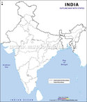
Outline Map
An outline map of any place shows the geographical boundary of that place. The outline map of India shows its international boundary. It is mainly just an outline drawn across those boundaries, which in turn reflects how the country looks like. At times, the outline map even shows the outline of different states and the Union Territories of the nation.
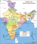
Political Map
A political map of any place reflects the different Union Territories and states along with their boundaries, capitals and main cities. In the political map of India, the different states and the Union Territories are color coded individually with some symbols like stars and circles used for a state capital or city.
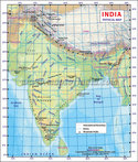
Physical Map
A physical map of an area illustrates its varied physical features, which includes mountains, plains, lakes, rivers etc. The physical map of India is not an exception. Different color codes are used to show the different features of India. Green is mostly used to show lower elevations. The more the altitude increases, the green color gets darker or orange and brown are used to indicate medium and higher elevation respectively. Water bodies are marked with blue though.
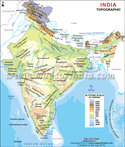
Topographic Map
A topographic map of India or any other place shows the curves, elevation and shapes of that area. Closely marked lines signify steep terrain whereas, lines, which are spaced out signify flat terrain.
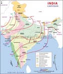
Climate Map
A climate map used in school, generally provides information about the different climatic conditions of a place. Mapmakers or cartographers use some specific colors to differentiate between the different climatic zones in India, mainly the precipitation zone.
Do these maps help school children in their studies?
 |
 |
 |
 |
||||
| India Climate | Outline Map of India | India Political Map | Physical Map of India | ||||
 |
|||||||
| Topographic Map of India |
Last Updated on: April 17, 2026
Maps for School Children