
Situated on the Deccan Plateau, the region has a total area of 1,14,840 square kilometers, the largest of the three regions of Andhra Pradesh. The most important rivers here are Musi, Krishna, Godavari and Manjira.
Before India became independent, the now-carved state was a part of Hyderabad which had two divisions, namely Warangal and Medak. The bifurcation of the state of Andhra Pradesh has been opposed on the grounds of territorial integrity. As per 2011 census, the region has a population of 35,286,757 which is 41.6% of the total population of Andhra Pradesh.
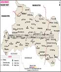
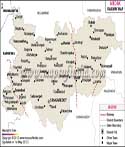
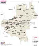
Rail Network in Telangana
Telangana comprises of districts that are well connected by rails that run all across the state. The map of Telangana shows various stations and railway routes that connects various places in the state. These routes are helpful in guiding a traveler to his destination. The state is not only well connected inter state but also intra state. As the state has been carved out of Andhra Pradesh which was already well connected with other states in the country, Telangana stands to benefit from it. People residing in the state can also enjoy a better rail connectivity for other states, which mean that they can visit other states without any hassle.
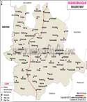
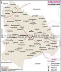
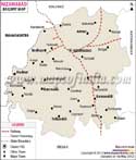
The already well laid out rail connectivity in the state is surely going to play a significant role in propagating commerce and tourism in the state. Telangana rail network connects all its major districts namely Adilabad, Nizamabad, Karimnagar, Medak, Warangal, Khammam, Rangareddy, Hyderabad, Nalgonda and Mahbubnagar. The major railway stations in the state are Adilabad, Nizamabad, Karimnagar, Mancherial, Warangal, Janampeta, Hyderabad, Khammam, Nalgonda, Mahbubnagar and Kurnool.
Last Updated on : May 11, 2026
Railway Map of Telangana