


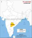
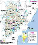
About Telangana
Telangana became the 29th state of India (on June 2, 2014). (Now it is the 28th state of India because Union government divided Jammu and Kashmir into two union territories) It was previously a part of Andhra Pradesh. Before India became independent, the area now called Telangana was included in part of the state of Hyderabad, governed by the Nizams, which comprised two divisions, namely Warangal and Medakwas merged into the Indian Union in 1948. At that time the region was as per the 2011 Census, the region had a population of 35,193,978, which accounted for 41.6% of the population of Andhra Pradesh. Telangana is divided into 31 districts.
History of the Formation of Telangana
The movement agitation to create a separate state of Telangana had started as long back as 1969. Over the years, the agitation intensified and gathered a lot of steam. There had been several movements, but the most important ones happened took place during 1969, 1972 and 2009. Over the years, the movement gathered a lot of steam.
The process of creating the separate state of Telangana was initiated on December 9, 2009, with a formal announcement from the Indian government. However, in protest, MLAs and MPs from the Rayalseema and Coastal Andhra areas tendered their resignations.
These regions also saw some violent protests after the said announcement. As a result of this, the Indian government was forced to put the process on the back burner in December of 2009. The Telangana movement, however, continued unabated in Hyderabad as well as in other districts of the region.
The process began intensified yet again on July 30, 2013, when the Congress party decided to plead with the Indian government to create the new state of Telangana. It was decided that Hyderabad would continue to be the joint capital of both Telangana and Andhra Pradesh for the next decade. The process met with the approval of the Union Cabinet on October 3, 2013.
A (Group of Ministers) GoM draft bill on Telangana was approved by the Indian government on December 5, 2013, following which the bill was submitted to the Parliament so that both the houses could vote on the same. The 15th Lok Sabha voted in favour of creating a new state on February 18, 2014, and the Rajya Sabha followed suit on February 20, 2014.
Pranab Mukherjee, the President of India, provided his consent to the decision on March 1, 2014, and the Gazette Notification for the same was brought out on the same day. It was announced by the Government of India on March 4, 2014, that the new state of Telangana would be created and hence it was formed on June 2, 2014.
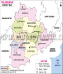
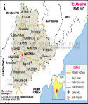
After two years, in October 2016, 21 new districts were created in the state. The districts included Siddipet, Jangaon, Vikarabad, Jayashankar, Jagtial, Peddapally, Warangal (Rural), Yadadri, Kamareddy, Medak, Mancheriyal, Mahabubabad, Rajanna, Asifabad, Kothagudem, Wanaparthy, Suryapet, Nirmal, Nagarkurnool, Jogulamba and Medchal/Malkajgiri.
The other ten districts in the state include Hyderabad, Adilabad, Mahabubnagar, Medak, Karimnagar, Warangal, Nizamabad, Ranga Reddy, Khammam and Nalgonda.
Along with the districts, revenue divisions, the manuals and other administrative units were also reorganised.
| Facts on Telangana | |
|---|---|
| Official Website | www.telangana.gov.in |
| Country | India |
| State | Telangana |
| Date of Formation | 2 June, 2014 |
| Largest city | Hyderabad |
| Coordinates | 18° N 79° E |
| Chief Minister | Anumula Revanth Reddy |
| Governor | Jishnu Dev Varma |
| High Court | High Court of Judicature at Hyderabad |
| Area | 1,12,077 km2 |
| Density | 307/km2 |
| Population (2011 Census) | 35193978 |
| Males Population (2011) | 17611633 |
| Females Population (2011) | 17392041 |
| No. of District | 31 |
| Capital | Hyderabad |
| Revenue Villages | 10434 |
| Revenue Mandals | 459 |
| Mandal Praja Parishads | 438 |
| Municipalities | 37 |
| Towns (as per 2011 Census) | 158 |
| Rivers | Godavari |
| Forests & National Park | Shivaram Wildlife Sanctuary, Manjira Wildlife Sanctuary |
| Languages | Telugu, Urdu |
| Neighbour States | Andhra Pradesh, Odisha, Chhattisgarh, Maharashtra, Karnataka |
| Literacy Rate (2011) | 66.46% |
| Females per 1000 males | 1010 |
| Assembly constituency | 119 |
| Parliamentary constituency | 17 |
Geography of Telangana
Boundaries:
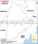
The state of Telangana is surrounded in its north-western and northern directions by Maharashtra. Karnataka encircles the region towards the west and Chhattisgarh lies to its north-eastern direction. To the east of Telangana is Odisha.Span:
In all, the region covers an area spanning 112,077 square kilometers.Rivers:
The most important rivers of this province are Musi, Krishna, Manjira and Godavari.Cities:
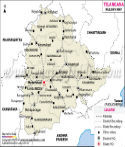
The largest cities of Telangana are Hyderabad, Nizamabad, Warangal and Karimnagar.Demographics:
Per the 2011 census figures, the population of Telangana stands at 35,193,978. The number of the male and female population is 1, 77, 04,078 and 2, 46, 48,731 respectively. The state has a total area of 1, 33,103-kilometre squares and the density of population is 307 per square kilometer.
| District | Population | Male | Female |
|---|---|---|---|
| Khammam | 2797370 | 1390988 | 1406382 |
| Nalgonda | 3488809 | 1759772 | 1729037 |
| Adilabad | 2741239 | 1369597 | 1371642 |
| Nizamabad | 2551335 | 1250641 | 1300694 |
| Rangareddy | 5296741 | 2701008 | 2595733 |
| Warangal | 3512576 | 1759281 | 1753295 |
| Karimnagar | 3776269 | 1880800 | 1895469 |
| Mahbubnagar | 4053028 | 2050386 | 2002642 |
| Hyderabad | 3943323 | 2018575 | 1924748 |
| Medak | 3033288 | 1523030 | 1510258 |
| Total | 35193978 | 17704078 | 17489900 |
Economy:
Agriculture is one of the most important sectors in Telangana. Crops like cotton, mango and tobacco are locally grown in the state. In the fiscal year 2015-16, the Gross Domestic Product (GDP) of Telangana was Rs 4.7 lakh crore. Nagarjun Sagar Dam and Godavari River Basin Irrigation Projects are the multi-state irrigation projects in the state. With a focus on information technology and biotechnology, Telangana is one of the top IT exporting states of India. With the presence of the coal reserves in Singaerni Collieries, Telangana is also considered a mineral-rich state.
Transport:
The bus service in Telangana is managed by the Telangana State Road Transport Corporation (TSRTC). The Indian Railway administration within the state is operated under the South Central Railway. The two main divisions of South Central Railway - Secunderabad and Hyderabad - are located in Telangana. Rajiv Gandhi International Airport is the largest airport in the state, which is also the busiest airport in the country. The government has plans to construct new airports in Kothagudem and Karimnagar and upgrade the existing airports - Ramagundam Airport, Nizamabad Airport and Warangal Airport.
Society and Culture:
The majority of the state's population speaks Telugu. Urdu is also widely spoken in some parts of the state. The culture is a combination of Persian customs dating back to the period of the Mughals and the Nizams. Many Hindu festivals such as Deepawali, Ramanavami, Ganesh Chaturthi, Maha Shivaratri and Muslim festivals such as Bakra-Eid and Eid-ul-Fitr are celebrated in this state. Bataukamma festival and Lashkar Bonalu are the state festivals of Telangana.
Language:
Telugu is the official language of Telangana, although some people claim that the Telangana Telugu is different than from the Telugu which is spoken in Andhra Pradesh. The Telugu language includes words from Sanskrit, Urdu and English language. Urdu was the official language of Hyderabad before 1948, but after the Hyderabad state joined the Republic of India, Telugu became the official language of the state. Telugu is also the medium of instruction in schools and colleges.
Government and Politics:
Telangana has a parliamentary system of government. The system is divided into three different branches. The executive authority lies with the Council of Ministers, headed by the Chief Minister of the state. There are 119 members in the legislative assembly and 40 members in the legislative council of the state. A system of lower courts and the High Court of Hyderabad take care of the judicial system of Telangana. The major political parties in the state are Telugu Desam Party (TDP), Telangana Rashtra Samithi (TRS) and Indian National Congress (INC). Telangana came into being after Andhra Pradesh Reorganisation Act, 2014 Bill was passed by the Parliament for carving out the Telangana state comprising ten districts from north-western Andhra Pradesh, in February 2014. The state of Telangana was officially formed on June 2, 2014.
Education:
Besides many private and public schools, there are also many higher education institutions and universities in the state. The schools are affiliated to the Central Board of Secondary Education (CBSE), or ICSE, or the state board. There are research institutions, colleges and universities which offer professional education in different fields including science, arts, humanities, law, medicine, etc. The University of Hyderabad, International Institute of Information Technology (IIIT) in Hyderabad, and National Institute of Technology (NIT) in Warangal are some of the important educational institutions in the state. The Electronics Corporation of India Limited and the Tata Institute of Fundamental Research in Hyderabad are some famous research institutes in the state.
Why is it called Telangana?
It is said that both the name “Telangana” as well as the language has come from the words “Trilinga”, or “Trilinga Desa”, which means “the country of the three lingas”. As per a Hindu legend, Shiva came down on three mountains called Kaleshwaram, Draksharama and Srisailam is a linga. These mountains basically acted as the borders of the region and are supposed to be situated somewhere between the rivers Godavari and Krishna. The word is also used in order to separate the Telugu- speaking region from the Marathi dominions and designate it as a part of the state of Hyderabad.
Why was Telangana created?
The supporters of Telangana cited discrepancies and deprivation in many areas such as water resources distribution, jobs and allotments of the budget as the basic reasons for creating a new state. The region used to contribute approximately 62% of the revenues generated in Andhra Pradesh. It has been stated that even though it had almost 69% of the catchment areas of both Godavari and Krishna, it received only around 19% of the benefit provided by the various irrigation projects. It has also been alleged that in the majority of the years the state government did not spend the money allotted for the development of Telangana.
Professor Jayashankar estimated that only 20% of government employees were recruited from the region. As far as the secretariat is concerned, the count goes down to around 10%, and only 5% of the officers who led various departments were from Telangana. He has also pointed out that in the 50 years of the state's existence; chief ministers from Telangana have served for only six-and-a-half years.
The proponents of Telangana have also pointed that the state legislature, as well as the Lok Sabha, has failed to honour the various agreements, promises and plans and this has left the state in a lurch of neglect, backwardness and exploitation.
Controversy and objection in creating Telangana
The creation of Telangana resulted in protests from various politicians in Andhra Pradesh. However, a major incident occurred on February 13, 2014, when the speaker Meira Kumar allowed the introduction of the bill at 12.00 hours. Slogans were raised and it was at this time that Lagadapati Rajagopal, the then-Congress MP from the Vijaywada constituency, used pepper sprays. He later went on to say that he had used it in self-defence since MPs from other states had attacked him. His actions caused a lot of disturbance to the proceedings of Lok Sabha and some members of the lower house of Parliament had to be hospitalised.
Several Andhra MPs also faced suspension from the Lok Sabha as a result of their actions. They were:
Indian National Congress
- Sabbam Hari
- A Sai Prathap
- Anantha Venkatarami Reddy
- Suresh Kumar Shetkar
- Rayapati Sambasiva Rao
- KRG Reddy
- SPY Reddy
- Bapi Raju Kanumuri
- M Sreenivasulu Reddy
- G Sukhender Reddy
- V Aruna Kumar
Telugu Desam Party
- Niramalli Sivaprasad
- K Narayana Rao
- Nimmala Kristappa
YSR Congress
- M Rajamohan Reddy
- Y Jaganmohan Reddy
| Sr. No. | District | District HQ | Population (2011) | Growth | Sex Ratio | Literacy | Area (km2) | Density (/km2) |
|---|---|---|---|---|---|---|---|---|
| 1 | Adilabad | Adilabad | 2741239 | 10.18% | 1001 | 61.01 | 16105 | 170 |
| 2 | Hyderabad | Hyderabad | 3943323 | 2.97% | 954 | 83.25 | 18480 | 217 |
| 3 | Karimnagar | Karimnagar | 3776269 | 8.15% | 1008 | 64.15 | 11823 | 322 |
| 4 | Khammam | Khammam | 2797370 | 8.47% | 1011 | 64.81 | 16029 | 175 |
| 5 | Mahbubnagar | Mahbubnagar | 4053028 | 15.34% | 977 | 55.04 | 18432 | 219 |
| 6 | Medak | Sangareddi | 3033288 | 13.60% | 992 | 61.42 | 9699 | 313 |
| 7 | Nalgonda | Nalgonda | 3488809 | 7.41% | 983 | 64.2 | 14240 | 245 |
| 8 | Nizamabad | Nizamabad | 2551335 | 8.77% | 1040 | 61.25 | 7956 | 321 |
| 9 | Rangareddy | Hyderabad | 5296741 | 48.16% | 961 | 75.87 | 7493 | 707 |
| 10 | Warangal | Warangal | 3512576 | 8.21% | 997 | 65.11 | 12846 | 274 |
Maps in Other Regional Languages
Last Updated on: May 11, 2026
Telangana Maps
List of districts in Telangana