Where is Jharkhand?
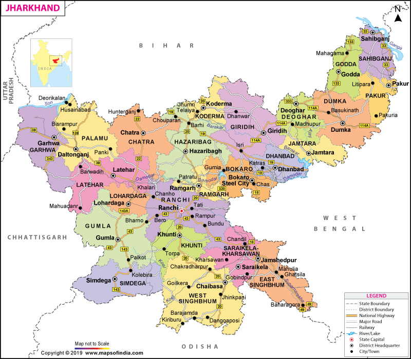
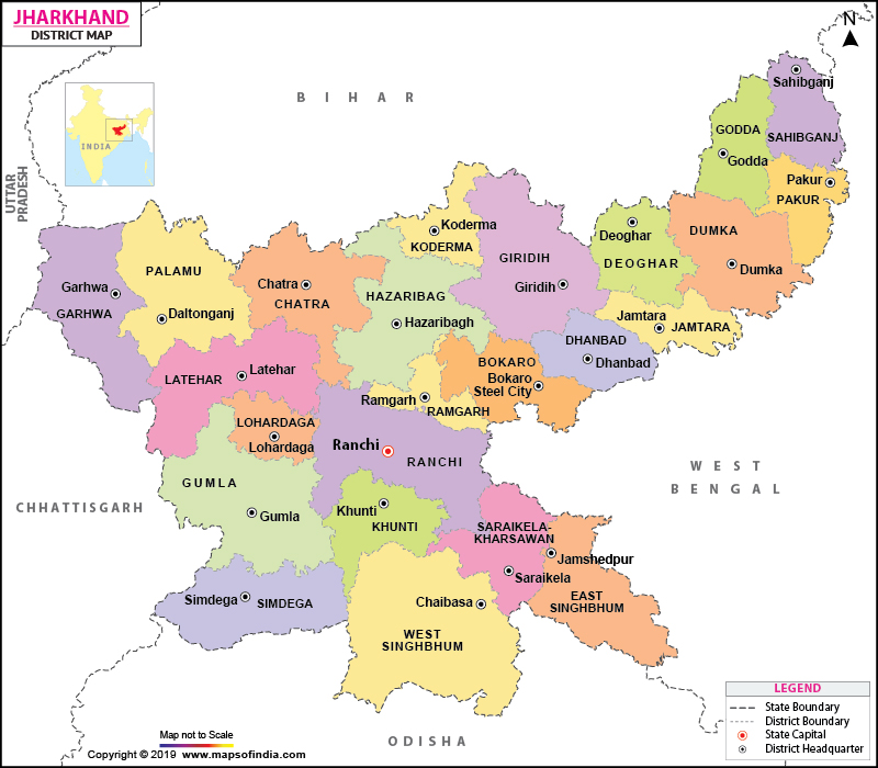
Jharkhand is located in the eastern part of India. The southern half of Bihar state was carved out on November 15, 2000, through the Bihar Reorganization Act to create the 28th state of the Indian Union. Jharkhand shares its border with Bihar to the north, West Bengal to the east, Odisha to the south, Chhattisgarh to the west, and Uttar Pradesh to the northwest. There are 18 districts in this state and has Ranchi as its capital city.
Read More: Capital of Jharkhand
What is the Geography of Jharkhand?
Jharkhand is spread across a total area of 79.72 lakh hectare (79,700 sq. km or 30,772 sq. mi). Over 37.30% (29.74 lakh hectares equivalent to 29,740 sq. km or 11,483 sq. mi) of the total area is cultivable area, 30% (23.92 lakh hectare equivalent to 23,920 sq. km or 9,236 sq. mi) is forest area, 2% (1.59 lakh hectare equivalent to 15,900 sq. km or 6,139 sq. mi) is water bodies, 9% (7.17 lakh hectare equivalent to 7,170 sq. km or 2,768 sq. mi) is waste land, 5.5% (4.38 lakh hectare equivalent to 4,380 sq. km or 1,691 sq. mi) is scrub forest, 5% (3.99 lakh hectare equivalent to 3,990 sq. km or 1,541 sq. mi) is built-up area, and 11.2% (8.93 lakh hectare equivalent to 8,930 sq. km or 3,448 sq. mi) is other land pattern.
Most parts of Jharkhand are located within the Chota Nagpur Plateau. A large part of Jharkhand is still covered by the forest, which houses a wide array of wild animals including Asian elephants and tigers. There are mainly five kinds of soils found in Jharkhand.
Red soil is mainly found in the Damodar Valley as well as the Rajmahal area. The Micacious soil consists of mica particles and is found in the Mandar hill area, Barkagaon, Jhumri Telaiya, and Koderma. In Dhanbad and Hazaribagh, the sandy soil is mainly found. The Rajmahal area mainly consists of Black soil. The fifth soil type is Laterite soil, which is mainly found in Palamu, Ranchi’s western part, and parts of Singhbhum and Santhal Parganas.
The highest elevation point in Jharkhand is the Parasnath mountain peak, located in the Chota Nagpur Plateau’s eastern end (in the Giridih district). The major mountains or hills in Jharkhand are Parasnath Hill, Trikut Hill, Fuldungri, Canary Hill, Tagore Hill, Ranchi Hill, Nandan Hill, etc. The main rivers in the state are Damodar, Mayurakshi, Phalgu, Ajay, South Koyal, Subarnarekha, Sone Rivers, etc.
What is the Climate of Jharkhand?
The northern part of Jharkhand has a humid subtropical climate and the south-east part has a tropical wet and dry climate. There are 5 distinct seasons found in the state: summer, monsoon, autumn, winter, and spring.
The season of summer starts in mid-April and continues till mid-June. May is the hottest month of the place when the average maximum daytime temperature reaches around 38 °C (100 °F) and the average minimum daytime temperature reaches around 25 °C (77 °F).
The southwest monsoon starts in mid-June and continues till October. While the west-central part of Jharkhand receives 1,000 mm (40 in) of annual rainfall, the southwest part receives over 1,500 mm (60 in) of annual rainfall.
Around half of the annual rainfall takes place during July-August. The season of winter starts in November and continues till February. The season of spring starts in mid-February and continues till mid-April.
What is the Economy of Jharkhand?
Jharkhand is endowed with rich natural resources. It houses 40% of the mineral reserves, 27.3% of the total coal reserves, 26% of the total iron ore, and 18.5% of the total copper ore of India.
The main minerals found in the state are uranium, coal, granite, bauxite, mica, magnetite, graphite, silver, gold, quartz, dolomite, feldspar, fireclay, etc. The mineral production in Jharkhand during 2017-18 was INR 2,070.39 crore (US$ 286.96 million).
The nominal GSDP (at current prices) of Jharkhand increased from INR 254,285 crore (around US$35,627,871.35) in 2017-18 to INR 283,657 (US$39,743,182.27) in 2018-19. The Department of Industrial Policy and Promotion’s (DIPP) data shows that during April 2000 to December 2018, the FDI equity inflow in the state was US$ 113 million of worth value.
The unique location of Jharkhand, especially its proximity to important ports of Kolkata (West Bengal), Haldia (West Bengal), and Paradip (Odisha), has helped in its surging mineral transportation, business, and trade.
Besides the mineral business, some of the other key sectors of Jharkhand economy are Tasar silk (it’s the largest producer in India), engineering industry (thanks to the availability of natural resources and raw materials including iron, steel, aluminum, copper, etc.), horticulture crops, and many more.
Despite the state’s phenomenal growth, at least 80% of the rural population is dependent upon agriculture. Over 50.4% of the population is associated with the agricultural sector. The rest of the working population in Jharkhand is associated with mining, construction, services sector, and finance. The rate of unemployment in Jharkhand is 3.1%, higher than the 2.7% national rate. Over 39.1% of the total 3.30 crore (33 million) population (2011 Census) in Jharkhand is reeling under poverty (which is higher than the 29.8% national poverty rate).
What is the Transportation System of Jharkhand?
Jharkhand has over 4,311 km (2,679 mi) long roadway, which includes 1,500 km (932 mi) long national highways and 2,711 km (1,685 mi) of state highways. Some of the major railway stations are Ranchi, Jamshedpur, Dhanbad, Bokaro, etc. Airways is also significantly developed in the state and the airstrips are located in Bokaro, Jamshedpur, Hazaribagh, Noamundi, Daltonganj, Deoghar, and Giridih. The major airports are Birsa Munda Airport, Bokaro Airport, Dhalbhumgarh Airport, Deoghar Airport, etc.
Read More: Jharkhand Road Map
What are the Popular Tourist Centers in Jharkhand?
The most popular attractions in Jharkhand are Udhava Bird Sanctuary, Ichagarh Bird Sanctuary, Chachro Crocodile Breeding Centre, Jawaharlal Nehru Zoological Garden, Dalma Wild Life Sanctuary, Tenughat Bird Sanctuary, Bhagwan Birsa Zoological Gardens, Palkote Wild Life Sanctuary, Tatoloi hot water stream, Saranda Forest, Hazaribagh National Park, Ranchi Aquarium, Betla National Park, Birsa Deer Sanctuary, Masanjore Dam, Jharkhand Dham, Tata Steel Zoological Park, Lagnta Baba Temple/Majar, Bindhvashini Temple, and others.
Read More: Places to Visit in Jharkhand


