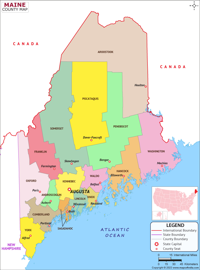
The Northeastern United States state of Maine is the furthest east in the New England region. Maine is the 12th smallest by area, the 9th least populous, the 13th least densely populated, and the most rural of the 50 states in the United States, making it the largest state by total area in New England. It is also the most northeastern state in the contiguous United States, the furthest northeast of the Great Lakes, the only state with a name that only has one syllable, and the only state with exactly one other state as a border. The 45th parallel north in latitude divides Maine's land into roughly equal halves.
Maine's capital is Augusta, while Portland is the state's most populous city.
Maine is well known for its rocky, jagged Atlantic Ocean and Bayshore coastlines, smooth mountain terrain, dense interior forest, picturesque waterways, wild lowbush blueberries, and seafood cuisine, particularly lobster and clams. Maine's coastal and Downeast regions have become significant hubs for the creative economy, particularly those close to Portland, which is also bringing gentrification.
History
On St. Croix Island in 1604 Frenchmen Pierre du Guast and Samuel de Champlain founded the first European settlement in Maine. They established the Acadia colony, which today's Quebec, Canada, and a portion of Maine were a part of. Under the Missouri Compromise of 1820, Congress added Maine as the 23rd state. This arrangement allowed Missouri to enter the Union as a slave state a year after Maine, maintaining the nation's balance of free and slave states in terms of population.
Culture
Low-bush blueberries are primarily produced in Maine in the United States. According to preliminary USDA data for 2012, Maine produced the most blueberries among the major producing states, amounting to 91,100,000 lbs. This information includes both low-bush and high-bush (cultivated) Vaccinium corymbosum blueberries.
With a $266 million sales value in 2020, medical marijuana surpassed blueberries and potatoes as the state's most valuable agricultural crop, according to Maine Revenue Services. In 2022, recreational cannabis sales came to $158.9 million.
Language
In Maine, a French party established the first European settlement in 1604. Languages spoken are 74. Top ten languages used: The majority of French and Micmac speakers in the US are found in Maine. There are also several English speakers.
Geography
Maine is located in a biome with mixed temperate broadleaf forests. Mixed oaks from the Northeastern coastal forests cover the land near the southern and central Atlantic coast. The New England-Acadian forests enclose the remainder of the state, which includes the North Woods. Geologists refer to this type of environment as a "drowned coast," where a rising sea level has encroached on former land features, forming bays out of valleys and islands out of mountain tops. Heavy glacier ice melting caused the elevation of the land to rise, which had a slight rebounding effect on the underlying rock. Despite this, the effect of the rising sea level and its invasion of former land features were still felt, even after the land elevation rose slightly.
| Official name | Maine |
| Capital | Augusta |
| Population | 13.7 lakhs |
| Area | 91,646 km² |
| Religion | Baptist family |
| Language | English |
| Currency | US Dollar |
| Major cities | Augusta, Portland, Bangor |
FAQs
Q1: What is the official language of Maine?
English is the official language of Maine?.
Q2: What is the capital of Maine?
Augusta is the capital of Maine
Q3: What is the currency of Maine?
American Dollar is the currency of Maine.
Q4: What is the climate in Maine?
The cold, snowy winters and cool, wet summers that define Maine's climate.
Last Updated on: August 23, 2023
